Category Water Engineering in Ancient Civilizations. 5,000 Years of History

The great reservoirs of Ceylon

About 544 BC the island of Ceylon (Sri Lanka) falls under the domination of princely families of Indo-European origin, coming from Maghada. The Ceylonese civilization develops markedly after the conversion of the island to Buddhism. This conversion is attributed to a certain Mahendra who, according to tradition, is said to be the son or the brother of the great king Afoka. Irrigation is a significant factor in the island’s develop­ment. Rainfall is abundant, but concentrated during the monsoon period. Since the soil is relatively impervious, very little of the rain is stored as groundwater. The only solu­tion is construction of dam-reservoirs.

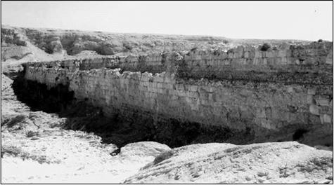
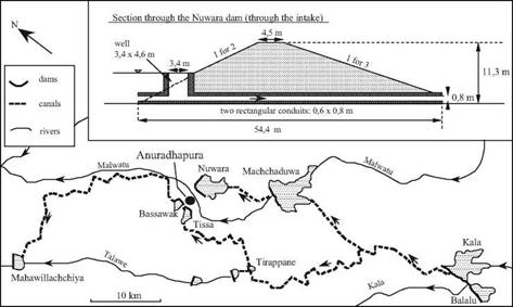
We can identify several reservoir-dam installations dating from 370 BC to 540 AD. They range in height from 5 to 20 m, and some are several kilometers long.[301] Eight of them are in the region of the capital Anuradhapura; three in the region of the great south­ern city, Magama, and four more near Polonnaruwa, which becomes the capital of the island after 781. All of these are earthen dams of trapezoidal section (Figure 7.3), fair­ly narrow at the top. The talus slope was rather steep for the first of these dams (370 BC), being 1:2.5 on both the upstream and downstream faces. Subsequent dams had somewhat flatter slopes, generally 1:3 on the downstream face (and in unusual cases, 1:5). These rather long dams are not rectilinear, but follow the terrain in such a way as to minimize their height and maximize the volume of stored water – which can be mul­tiples of ten million cubic meters for the larger reservoirs. One dam near Polonnaruwa is an exception to this general configuration. It is relatively short, but is built to a height of 17 m at the time of its initial construction in around 300 BC, and then is raised to 34 m in 460 AD. Depending on the dam, floodwaters are spilled either over a natural rocky sill, or over a thick stone wall covered with a layer of large blocks. Often several dams are built on the same river, or on different tributaries of the same watershed. From the 5th century AD, canals that are 15 to 30 km long transfer water from one valley to anoth­er within the same overall watershed.

One of the reservoir-dam installations in the northwest portion of the island is gigan­tic, having an immense reservoir of 39 million cubic meters. The reservoir is contained by a semi-circular dike that is 9 km long. This project was first undertaken in the 12th century AD by the king Parakrama Bahu, but it remained unfinished, the necessary efforts exceeding the capacities of the population. Eventually Tamil invaders, coming from the south of the Indian subcontinent, replace the authoritarian dynasty that had developed such vast hydraulic resources for the island of Ceylon. The Tamils neither maintain nor further develop the hydraulic systems, which therefore progressively fall into decay and ruin.

The great reservoirs of Ceylon

Figure 7.3 Development of the basin of the river Malwatu near the ancient capital of Ceylon, Anuradhapura. The first man-made reservoirs are those of Bassawak and Tissa (about 300 BC), then Nuwara (80 BC), Balalu (40 BC), Mahawilachchiya (70 AD), then Kala and Tirappane (around 470 AD) and Machchaduwa (540 AD). The sketch shows the state of the development at the end of the 6th century AD, and the structural details of the Nuwara dam, 4.8 km long, creating a reservoir of 43 million cubic meters. After Schnitter (1994).

Irrigation in Ancient India

Agriculture is the foundation of the economy of India, and consequently the practice of irrigation is widespread. In the above introduction, we have tried to give some idea of the broad cultural mixing that took place in this country. Because of this mixing, com­bined with India’s traditional lack of interest in its own history and the difficulty of dat­ing Sanskrit texts, it is quite a challenge to find the origins of innovations, and some­
times even to identify references to original hydraulic works in the texts. Nonetheless, ancient documents do mention the existence of canals, reservoirs, gates, and machines for lifting water.1 The lifting wheel (“rotating wheel fitted with buckets”) is mentioned with a date that is perhaps 350 B. C. but impossible to confirm.[299] [300] Moreover, it is impos­sible to know if this description refers to a simple wheel, a bucket chain (saqqya), or per­haps a true hydraulic noria, which seems unlikely.

Beyond Rome, The East And The Arab World

Beyond the Roman Empire – Persia and India

Between the Tigris, the Ganges, and the Oxus: multicultural influ­ences

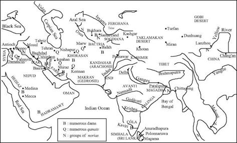
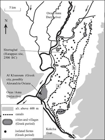
The Indus valley had harbored the great “hydraulic” civilization of Harappa between the third and second millenia BC. This civilization would develop to have exchanges with the Mesopotamian millenia, and had extended its influence along the “lapis-lazuli route”, to the north of the Hindu Kush mountains in Bactria (Figures 1.3, 7.1). After the collapse of this civilization only the trading posts to the south remained, at and around the mouth of the Indus at Lothal. Development later continues in the Bactria – a pros­perous civilization grows on the banks of the Oxus and its tributaries, a civilization that uses gravity canal irrigation in the cultivation of terraces overlooking the rivers (Figure 7.2).

The ancient Indian civilization grew from Indo-European (Aryan) migration from the northwest in the middle of the IInd millennium BC. The earliest Vedic texts, written in Sanskrit around the 6th century BC, give us our earliest distinct portrait of the devel­opment of this civilization. The birth of Buddha is placed in this century at about 560 BC.

After the fall of the Persian Empire and the death of Alexander, all of the region from Mesopotamia to the borders of India becomes the domain of Seleucos, one of Alexander’s generals, and then of his descendents the Seleucids. In India itself the Maurya Dynasty, 313 to 180 BC, includes a period of unification from the Ganges to the Indus under the grand sovereign Afoka (about 269 to 232 BC). The development of writing first appeared in his reign, as did the humanistic principles inspired by Buddhism. Only the extreme south of India and Ceylon (modern-day Sri Lanka) are not included in this unification.

Around 250 BC the Parthians from the north of Iran push the Seleucids back toward Syria and settle in Mesopotamia. In so doing, they isolate Bactria and Sogdiana from the rest of the Hellenistic world. This is the beginning of the Greek kingdom of Bactria, destined to spread Hellenistic culture toward India. Around 200 BC, Bactria’s king Euthydemus and his son Demetrius set out to conquer large regions of India. These Indo-Greeks were subsequently pushed back out of Bactria by a people who are known to us through Chinese history as the Yuehzi. The Chinese, pushed to the north by the Xiongnu (fellow nomads of unsavory reputation and who were likely the ancestors of those whom we now call the Huns), try to form alliances with the Yuehzi. In the 1st cen­tury BC, the Yuehzi found the empire of the Kuchans, occupying all the high valleys of the Ganges and the Indus up until the 2nd century AD. The stability of the great empires across these centuries – Rome to the west, the Parthians and the Kuchans in Asia, the Chinese empire of the Han Dynasty to the east – favors development of the Silk Road.

Meanwhile in Ceylon there are many signs of active commerce with Roman merchants.

The power of the Arabs rises in the near east during this time. In 640 AD the Arabs take Alexandria, occupying Egypt and destroying the Sassanide Persian Empire that had supplanted the Parthians from the 4th century BC. Having been confined to the Indus for a long time, the Arabs occupy Sind as well as Samarcand in 712, and in 751 they affront the Chinese armies on the Talas River to the northeast of Samarcand, in the loop of the Iaxartes (today the Syrdarya). This was an Arab victory in principle, but in reali­ty it marked the end of their expansion toward the east. With the decline of authority of the caliphs of Baghdad, the Ghaznavid Turks become the masters of Persia at the end of the 10th century AD. India collapses under their blows around 1000 AD, and all the north of the country is pillaged. Then successive waves of Mongols sack Mesopotamia in 1258 AD, and continue to ravage the north of India as far as Delhi in 1398 AD. Turkish-Mongol regimes control the sultanate of Delhi from the 13th century AD, and control the entire northern half of India until the 17th century, including the Ganges and Indus valleys.

Beyond Rome, The East And The Arab World

Figure 7.1 From the Syrian coast to the heart of China, in the ancient and medieval eras. Cities whose names are underlined are the great capitals: Ctesiphon for the Sassanide Persians, Balkh (Baktria) for the Greek kingdom of Bactria, Damascus and Baghdad for the Ummeyyades and the Abbassids, Pataliputra (Patna) for the India of the Mauryans and the Guptas, Delhi for the Turkish sultanate that dominates the north of India in the XIIIth century, Chang’an for China of the Han and Tang dynasties.

Figure 7.2 Irrigation of the plain of АЇ Khanoun in eastern Bactria, at the confluence of the Oxus (Amou Daria) and the Kokcha. АЇ Khanoun was probably the Alexandria of the Oxus. The map shows the population patterns and the traces of the principal irrigation canals during the time of the Greek kingdom of Bactria. These principal canals rise from the Kokcha and run along the plateau toward the north. The Oxus flows in an adjacent lower course, 20 m below the irrigated plain, which is why its water could not be used. After 37 centuries of irrigation using this same basic layout of canals, the plain returns to desert after the Mongol invasions of the 13th century AD (Francfort, 1989; Gentelle, 1989; Gardin, 1998). For an overview map, see Figure 1.3.

a. Beyond Rome, The East And The Arab WorldCanal trace dating from the Bronze Age (IIIrd millennium BC) passing by the Harapan site of Shortughai. It supported irrigation of 6,000 hectares of barley, wheat, lentils, and sesame.

b. Canal developed before or during the time of the Persian Empire (Figure 2.20)

c. New canal built in the time of the Greek kingdom of Bactria. It brings the irrigated area to

16,0 hectares. It is abandoned, and then restored with the same general alignment during the Islamic period.

Roman hydraulic knowledge and knowledge transfer

An observer of the vast array of Roman technical achievements can only be surprised and disappointed at the lack of technical documentation left by the Romans. With the exception of Vitruvius, whose technical descriptions are sometimes precise (the water mill), and sometimes extremely vague (the aqueducts), there is simply no body of tech­nical literature as we know it. We have extensively cited Frontinus’ book on the aque­ducts of Rome, a remarkable work. Yet it is much more of a precise and documented “audit” report than a manual for the guidance of future builders. Pliny’s The Natural History is precious and perhaps an exception, but it has little to do with hydraulic works. It seems that the attitude of the educated Roman leisure class insofar as applied sciences were concerned, tends toward that of the ancient Greeks in retreating from the attitude of the Hellenistic world: the application of knowledge is culturally devalued. Therefore treatises are not written about techniques. It is hard to imagine, for example, such a dearth of technical documentation after the works of Archimedes.

As a consequence, one finds great diversity in the technical solutions found in Roman projects. There are as many exceptionally well conceived works as there are very poorly conceived ones, whether it be in the domain of aqueducts or dams. It is true that in the three largest dams of Spain (Figure 6.29) one sees a certain technical progres­sion, if indeed these dams were built in the order that is thought to be correct. But in the Orient, for example, one finds as many solid and long-lasting retention dams (for example the dams of Homs, and of Harbaqa) as dams whose stability is very problemat­ic, because of an excessive height-to-width ratio.

Another anomaly in the transmission of Roman techniques is visible in the aque­ducts that have very large variations of slope from one point to another along their length. The canals in these aqueducts are constructed in anticipation of a constant depth, and yet in steeper segments, the water velocity is greater and, as a consequence, the actu­al depth of water is less.[295] [296] On the other hand one can see on several aqueducts (at Nimes, for example, but it is not the only one) that, along segments of small slope, the canal walls had to be raised after the initial construction, to prevent overflow. With so many successful projects behind them, how could the Romans not have already experi­enced this problem and drawn conclusions from it?

Similarly, another problem that has been intriguing to researchers is the Roman eval­uation of the discharge of their aqueducts. The quinaria, as we have seen earlier, is a unit of area. It is used by Frontinus as the only reference to determine the quantity of water being delivered. And in Table 6.2 we have, like Frontinus, used a unique equiva­lence between quinariae and discharges in m3/day. In reality, this equivalence has to be extremely variable. If we consider only several aqueducts of Rome, all having the same slope and the same wall roughness, Table 6.5 shows an important variation, from one aqueduct to the other, of the equivalence between sections (quinariae) and discharges.

Table 6.5 Calculation of the discharge of three aqueducts of Rome.92 Variation of discharge corresponding to one quinaria.

Aqueduct

Canal width (m)

Section after Frontinus (quinariae)

Water depth calculated from the area (m)

Calculated velocity (m/s)

Calculated

discharge

(m3/day)

Discharge correspon­ding to 1 quinaria

(m3/day)

Tepula

0.8

445

0.23

0.69

11,214

25.2

Juilia

0.7

1,206

0.72

0.95

41,567

34.5

Anio Novus

1

4,738

1.99

1.35

232,059

49.0

Were the Romans ignorant of this fact? In reading Frontinus, and in particular the fol­lowing significant extracts, it would seem that they were not ignorant of it:

“Let us remember that every stream of water, whenever it comes from a higher point and flows into a reservoir after a short run, not only comes up to its measure, but actually yields a sur­plus; but whenever it comes from a lower point, that is, under less pressure, and is conducted a longer distance, it shrinks in volume, owing to the resistance of its conduit; and that, there­fore, on this principle it needs either a check or a help in its discharge.

“But the position of the calix (intake) is also a factor. Placed at right angles and level, it maintains the normal quantity. Set against the current of the water, and sloping downward, it will take in more. If it slopes to one side, so that the water flows by, and if it is inclined with

the current, that is, is less favorably placed for taking in water, it will receive the water slow­ly and in scant quantity.”[297]

There is both right and wrong in this observation, but in any case there is an intu­itive understanding of the importance of the velocity, and even of what hydraulicians today call the ”head”. The importance of the velocity in evaluating the discharge appears even more clearly in this additional extract:

“Whence it appears that the total found by me is none too large. The explanation of this is, that the swifter current of water, coming as it does from a large and rapidly flowing river, increas­es the volume by its very velocity.”[298]

This intuition as to the importance of the velocity in determining the discharge was not sufficiently strong to be put to use. What has always seemed incomprehensible is the lack of any connection between the knowledge that Frontinus demonstrated – or did not demonstrate – and the work of Heron of Alexandria. We described this work in Chapter 5, and it has long been assumed to have come before Frontinus’ work by at least a century. We now know with certainty that Heron could not have done his writing before 60 AD. Frontinus, while he was studying the aqueducts of Rome, could therefore have been perfectly ignorant of the work of Heron, if indeed that work predated his. It

К

Roman hydraulic knowledge and knowledge transfer

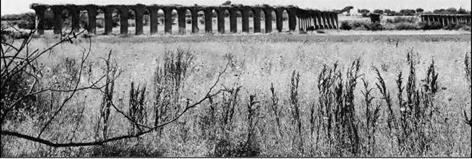
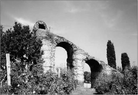
Figure 6.39 Remains of the arches of an aqueduct near Rome, between the via Appia Antica and the via Appia Nova (photo by the author).

is perhaps even possible that it was after having read Frontinus that Heron was led to write down the correct expression for discharge, as the product of the velocity and the cross-sectional area.

One technology that clearly and uniquely represents Roman know-how is the inverse siphon, such as the one that can be seen in the aqueduct of Gier at Lyon. The number of pipes in each siphon is in effect fixed a priori by the size of the head tank,

and by the number of outlet openings in the downstream wall (Figure 6.13). Lacking valves for control of the discharge of the pressurized pipes, one could compensate for dimensioning errors only by plugging one or several of these openings – an expedient visibly employed for certain siphons of the aqueduct of Gier. If the discharge of the pres­surized pipes turns out to be too large, causing emptying of the head tank and conse­quently a dangerous aspiration of air into the siphon, it is thus possible to reduce the dis­charge. But one has to wonder what expedients were used when, on the contrary, the capacity of the siphon was insufficient, causing the head tank to overflow.

In assessing the technical contributions of the Romans, one must also remember the

Roman hydraulic knowledge and knowledge transfer

Figure 6.40. Aqueduct of Gier for Lyon: seen from the upstream end of the siphon of Yzeron, at the place called “le plat de l’air”. From left to right: hidden behind the trees, the arches that support the canal, the remains of the head tank, and the ramp, the inclined plain that carried the lead pipes descending into the valley to the bridge-siphon (photo by the author).

heritage they received from their predecessors, professors and enemies – the Etruscans. The arch, as well as water supply and drainage works, are part of this heritage. We must also not forget to add to the list of Roman shortcomings their inability to maintain the Etruscan systems for land drainage and maintenance built before them in Italy. In their own country, the Romans allowed so many fertile lands to revert back to swamps, soon infested with malaria – for example the famous Pontin marshes. The lazy urbanites of Rome could have produced wheat on these lands, and relieved somewhat the desperate state of the Egyptian peasants.

Other Roman ports and navigation works

We should not forget the role of the port of Alexandria during the Roman period, as it closely follows the Ostia complex in importance. The port was built in the Hellenistic period, and we have already described it at the beginning of Chapter 5 (Figure 5.2). A squadron of Roman warships is based at the port, a point of departure for Egyptian wheat bound for Rome (via Pouzzuoli before completion of the port of Trajan). But Alexandria is also an intermediate stop for products coming from Sudan, Arabia, and the extreme Orient. The Romans continue to use and maintain the canal of Necho that we described in Chapter 3. Trajan develops Clysma (Suez) and undertakes repair of the canal.[292] The canal constitutes one of the routes to Arabia, India, and China, without ever really seri­ously challenging the grand ports of the Red Sea (Myos Hormos, on the site called Qoseir on Figure 3.1, and Berenice, formerly Head ofNekheb).

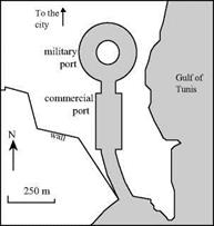
The port of Carthage, the most important of Africa, is also a point of departure for wheat bound for Rome. We have mentioned the wealth of the Roman Cartago earlier, from its refounding by Augustus in 29 BC up until the 7th century AD when it is des­tined to be eclipsed by the modern Tunis. The port has two basins (Figure 6.37), one for military uses and the other for commercial traffic.

Other Roman ports and navigation works Other Roman ports and navigation works

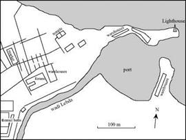
It would be difficult to mention all the other Roman Mediterranean ports. Some are excavated into level ground or in natural creeks, like Carthage and Marseille; others are developed in the mouth of watercourses, as is partially the case of the complex of Ostia, often with the same accompanying problems of sediment management. The port of Leptis Magna, the native city of Septimus Severus, is situated in the mouth of the wadi Labda. This emperor develops the port (Figure 6.38) and erects a lighthouse there. As a typical Mediterranean watercourse, the wadi Labda is subject to rapid and violent floods, and these can endanger vessels or cause other significant damage. As we have

Figure 6.37 The port of Carthage Figure 6.38 The port zone of Leptis Magna (after

(after Scarre, 1995). Scarre, 1995).

seen for some other African dams, a flood diversion structure is built upstream on the wadi Labda. A similar scheme is used by the Romans for Seleucid, the port of Antioch (with a 130-m long tunnel, followed by a 700-m long open cut, 6 to 7 m wide).

The Romans are not great canal builders – even though they maintain and use the Necho canal, or canal of two seas, and rename it the canal of Trajan after this emperor’s work on it. There is some fainthearted thought given to the construction of a canal at Corinth, cutting across the isthmus to enable ships to avoid having to sail to the south of Peloponnese. Caesar, Caligula, and Nero are tempted by this project, and initial work is begun.[293] But there is concern that the sea level may be different from one end of the canal to the other,[294] and that the opening of the canal would provoke a catastrophe. Or perhaps it was simply that the economic stakes were not high enough, for Greece is, under the Empire, more of a symbol than a significant economic player. In any case, the canal was not built in Antiquity.

Ostia and the imperial ports of Rome

Rome’s food supply depends on the chain of maritime transport of wheat from Numidia and Egypt. For a long time Rome could offer only minimal port facilities to cumber­some and large loaded boats needing to enter the Tiber at Ostia. Mooring there was especially dangerous when the Auster, an ill-reputed west wind today called the Libeccio, blew. Moreover, access by large boats was made problematic by a shoal. Here is how Strabo describes the situation, in about 25 AD:

“This city has no port, owing to the accumulation of the alluvial deposit brought down by the Tiber, which is swelled by numerous rivers; vessels therefore bring to anchor further out, but not without danger; however, gain overcomes every thing, for there is an abundance of lighters in readiness to freight and unfreight the larger ships, before they approach the mouth of the

river, and thus enable them to perform their voyage speedily. Being lightened of a part of their

81

cargo, they enter the river and sail up to Rome, a distance of about 190 stadia.”01

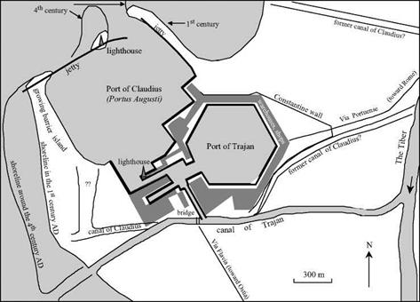
Boats coming from Alexandria or Antioch at this time, after fifteen to twenty days at sea (and sometimes twice that long), prefer to unload in the bay of Naples, at Pouzzuoli (Puteoli). Their merchandise then continues on to Rome either by land or sometimes in smaller boats capable of sailing up the Tiber. Navigation between Pouzzuoli and Ostia is dangerous, since the coast is low and lacks shelter, and therefore Rome is often threatened with shortages. Plans to create a true port at Ostia are proposed under Caesar and Augustus; these plans are often subject to long dissertations. But the first attempt to implement such plans must await Claudius, whom we have already seen as a great hydraulic entrepreneur. A 70-hectare basin (700 m by 1,000 m), excavated

behind the shelter of a naturally growing barrier island, becomes a first basin of the port.

Two large jetties are constructed to protect it; the most offshore one is built of large limestone blocks tied together by iron grapples cemented with lead;[286] [287] it is 330 m long and 23 m wide. Beyond this breakwater a ship was sunk and filled with sand to serve as a subfoundation for the construction of a four-story lighthouse. This was the great 100-m long ship that had been used by Caligula to bring from Egypt the obelisk that now is in Rome’s Place de Saint-Pierre:

“Claudius created the port of Ostia, constructing two jetties in circular arcs to the right and left, and in quite deep water, a breakwater to block the entrance; to seat this breakwater more solid­ly, one began by sinking the ship that had brought the great obelisk from Egypt; upon it, one constructed a great number of piles supporting a very high tour, destined, like that of Alexandria, to illuminate with its fire, during the night, the shipping route.”°J

Work on the port of Ostia proceeds from 42 to 54 AD. The project is finished after the death of Claudius and inaugurated by Nero, who associates his name with the achievement, without completely claiming it as his own, in naming itportus Augusti: the port of the Emperor. Two canals are excavated from the Tiber, obviously to connect the port to the river, but perhaps also to protect Rome by facilitating the drainage of flood- waters of the Tiber to the sea.[288] Somewhat later, the base of the lighthouse is joined to the west breakwater; other boats are sunk to facilitate the initial construction.

But the works of Claudius at Ostia remain inadequate to meet the needs of the city of Rome. Wheat from Alexandria continues to be offloaded at Pouzzouli, not Ostia. Moreover, the port at Ostia has a tendency to fill with sand from the alluvia of the Tiber brought through the canal(s) that link the river to the port, and from the littoral currents that sweep the alluvia of the mouth of the Tiber toward the north. Therefore Trajan excavates a second basin of 32 hectares from 100 to 112 AD. The basin is in the shape of a hexagon with sides of 358 m, a depth of 5 m, and linked to the first basin (Figure 6.36). A new lighthouse is built at the entrance of the canal linking the two ports. The canal coming from the Tiber is retraced: it constitutes a second mouth of the river and is called today the Fiumicino. The new port is connected to this canal, but little of the Tiber’s flow and sediment circulate through the port, which therefore minimizes silta – tion. The overall project eventually will support and receive all maritime traffic with goods destined for Rome. The work is completed, still under Trajan, by creation of an artificial port at Civitavecchia (Centumcellae) to the north, and by improvements at Terracino, about halfway between Pouzzouli and Ostia, to provide shelter along this

coast.[289]

The vast complex of ports of Claudius and Trajan, called Portus, is further improved and maintained under Septimus Severus, and then under Constantine. The complex remains active until the 5th century AD, but then suffers from the decrease in Roman population following the fall of the Empire, and progressively decays. In the 5th centu­ry the sea level is thought to have risen sufficiently to submerge the barrier island that protects the port of Claudius from the west. At this time work is done to provide protec­tion for the canal that links the two ports.[290] The blocks of Claudius’ large jetty to the northwest become partially disconnected, since the structure, lacking the protection of rock armor, was vulnerable to wave attack. There is intense alluvial deposition in the outlets of the Tiber, from the 15th century, and the port complex ends up being land­locked. The remains of the port of Claudius are now beneath the international terminal of the Rome airport. Today’s traveler therefore arrives at the same spot as did the ships from Carthage, Tarraco, and Massilia in the first century.[291]

Ostia and the imperial ports of Rome

Figure 6.36 The complex of imperial ports of Rome, after Trajan’s work (Le Gall, 1981; Redde, 1983).

Mediterranean ports in the Roman period

Under the Republic, the Roman provinces were resources to be exploited for the sole benefit of Italy. Later on, the emperors came to understand that the cohesion of the Empire depended on the prosperity of the provinces. As the 2nd and 3rd centuries of our

era unfolded, the economic situation of the provinces flourished; a number of them offi-

79

cially declared their wish that “the Roman domination should last eternally.” Maritime navigation is the most effective link among these provinces, and also the most economical. Transport ships plow the Mediterranean Sea, the mare nostrum of the Romans, at least during the warm season – from September to May navigation is offi­cially forbidden on the mare closum. In reality, the navigation period is between March and November. The largest merchant ships are those that transport wheat, routinely dis­placing 200 of our modern tons and measuring 25 m in length – some attain 60 m.

Merchandise circulates widely – from the granaries of Numedia (present-day [283]

Mediterranean ports in the Roman period

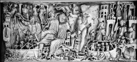
Figure 6.35 Harbor scene on a Roman sarcophagus (photo by the author)

Tunisia), Sicily, and Egypt[284] [285] toward the large Italian cities to be fed; from the regions of oil production, such as Tripolitania, the south of Spain, the north of Syria; from Greece whose wine is highly valued, and also from the regions of Bordeaux (Burdigala), Tarragona (Tarraco), and the south of Gaul, already renowned for their wine. Some of the goods come from far away, like silk from China, spices from southeast Asia, and incense from Arabia. Under the Empire, merchants based at Alexandria or Antioch forge the first direct relations with China of the Han Dynasty.

All of this merchandise attracts pirates, the restive adventurers of the pax romana, often spawned by the upheavals that accompany the progressive annexation of the Orient. Piracy in the Mediterranean is reduced somewhat after the naval victory of Pompeii, and it is eradicated at the beginning of the Christian era, an achievement of Augustus and his son-in-law Agrippa. The Roman military fleet had its beginnings in the Punic wars (3rd century BC). Subsequently, the Empire maintains a military fleet whose squadrons are based at Miseno (near Pouzzuoli, in the Gulf of Naples); at Ravenna, on the Adriatic in the northwest of Italy; and at Alexandria.

Development of the Roman Orient

During the last years of the Republic, Greece, Anatolia, Syria-Palestine, Egypt, and Cyrenaica had become Roman. This process began with the bequeathing of Pergamon to the Roman Republic, and was marked by Augustus’ taking possession of Egypt in 31 BC, and continuing through the tumult of the many wars during the last years of the Republic. There is not much to say of Greece, for she was knocked flat by wars and never got back on her feet economically. The reader may recall the development works at lake Copais undertaken in the Mycenaean era (Figure 4.10), and somewhat restored by Alexander the Great. Several sources mention that during the Roman period the lake’s dikes are no longer maintained, that the adjacent cities are subject to flooding, and that the best land must be abandoned.[273]

Other lands of the Orient fare differently. Trajan reaches the Persian Gulf in 116 AD after having conquered the Parthians, but in the end Rome is able to hold onto only the extreme northwest of Mesopotamia. Thereafter, the Orient provides Rome with emper­ors: Septimus Severus marries the daughter of the sun-god priest at Homs (Emesa), and his son Caracalla is therefore half Syrian. His successors, Elagabal and Severus Alexander, from the maternal side of Caracalla’s family, are entirely Syrian. In the mid­dle of the 3rd century AD, when the Empire is threatened along all of its borders, the Sassanide Persians reach Antioch and, to add to the humiliation, take the Emperor Valerius and all of his army as prisoners, in 260 AD. At Palmyra, queen Zenobia seizes the opportunity to launch offensive military expeditions, taking Alexandria in 270 AD. But in 272 AD the new Emperor Aurelius retakes control of all of the Roman Orient, and it remains peaceful for an extended period. Diocletius begins to create an autonomous Roman Orient, in dividing political power among four emperors and establishes his own capital at Nicomedia, near Byzantium. In 330 AD the Emperor Constantine takes per­sonal control of all of the Empire, but especially favors the Orient and transforms the Greek city Byzantium into Constantinople, the new capital of the Orient. When Rome falls in 410 AD, the Roman Orient remains standing.

Egypt is arguably the least Roman of the lands of the Empire, and it retains its iden­tity under Roman domination. Its governance continues under the Ptolemaic tradition, though the peasants are under increasingly oppressive fiscal pressure. Over and above direct taxation, they must meet a number of other obligations. Just as in the Ptolemite period (and also probably in the Pharaonic era), they are obliged to work on maintenance of the dikes.[274] During the time of the Pharaohs, Egypt had only to feed herself. But under the Ptolemites, she must in addition produce the surpluses necessary for the grand political ambitions of her leaders. Then under the Romans, Egypt must also feed the great cities of the Empire (and the city of Rome first and foremost), a heavy burden shared with only a few other provinces such as Numid.

In response to these needs, the Egyptians further develop the Fayoum irrigation sys­tem – dropping the lake level down to its present level to reclaim additional land, and cleaning out the canals. Moreover, they maintain the qanats that had been constructed by the Persians in the Kharga oasis and even build new ones. The small oases of Dakhla, Farafra, and Baharya to the north of Kharga appear to have flourished during the Roman period, and this success is likely attributable to the qanats built by the Romans.[275] According to Henri Goblot, it is indeed in Egypt that the Romans learned how to build these very special devices.

The city of Alexandria continues to be a great intellectual center under the Romans, as we have seen in Chapter 5. Alexandria is a cosmopolitan city with a population of some half million,[276] and it is in a state of constant turbulence. It is said that Carcalla, the son of Septimus Severus, had the sword taken to all the young people of the city in the spring of 215 AD after they had publicly criticized him.

Some fifteen Roman dams are found in the Orient – in Anatolia, Syria-Palestine and in the northwest of Mesopotamia. Other hydraulic works are to be built by the Byzantines after the fall the Occidental Roman Empire. The structure thought to be the oldest has a very specific purpose. It is 16 m high and 60 m long (but only 5 m wide, and therefore of precarious stability), and was built in 80 AD to divert floodwaters and protect the port of Antioch on the Orontes.[277] Antioch is the ancient capital of the Seleucids and an opulent capital of the Roman province of Syria.

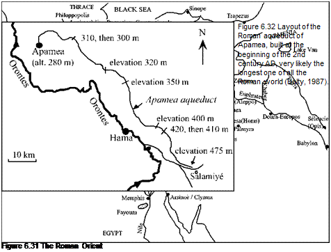
Earlier in this Chapter we mentioned some of the aqueducts built in the Orient, like the one at Apamea on the Orontes (Figure 6.32), perhaps the longest of all those in the Roman Empire. The water supply of Jerusalem (Aelia Capitolina from Hadrian) is one of the most famous ones of the Orient, given its symbolic importance. The pools of Solomon, vast reservoirs 13 km south of Jerusalem that are created by dams, store

200,0 cubic meters of water. An aqueduct begins at a reservoir situated near Hebron, connects this reservoir to the pools of Solomon, and then continues to Jerusalem, pass­ing through the center of Bethlehem, very close to the Cave of the Nativity. These installations have often been incorrectly attributed to King Solomon. In fact, they should be attributed to the Roman governor Pontius Pilate, at the very beginning of the

Development of the Roman Orient

Christian era.

Other hydraulic projects were built for the storage of irrigation water. Two of them, both located in Syria, merit our attention.

On the Orontes there is a very large lake formed by a dam built around 1935 over

the remains of a famous ancient dam, 12 km southwest of Homs (the Roman Emesa).[278] In Antiquity, this dam served the same function of maintaining the lake of Homs (at a level three meters lower than the modern dam). According to the study conducted in 1921 by Louis Brosse, the dam was 850 m long[279] and at most seven meters high. The dam is very stable thanks to its broad width, 15 to 20 m in its central portions. Four over­flow weirs, two each on the right and left banks, carry water to canals that lead to the city of Homs and agricultural zones.

A curious feature of this installation is that when the dam was first built, the normal course of the Orontes downstream of the dam is not supplied by water from the spillway, but rather by copious percolation through the face of the dam itself, a face obviously not at all watertight. Modern observers attribute this dam to the Roman period, based on its architecture of a fill of rough-stone concrete between walls of quarry stone. More pre­cisely, the dam appears to date from the year 284 AD, first year of the reign of Diocletius. The dam reflects the prosperity of the city of Emesa at this time.

But these same observers used to believe, in the 1980s, that the dam was much older, having been constructed by the Pharaoh Sethi I, in the 13th century BC, when Egypt dominated this region. The very ancient city of Qadesh was the site of a famous battle between Egyptians and Hittites. One must also consider the account of Strabo, who sit­uated one of the sources of the Orontes near the “Egyptian wall, toward the territory of Apamea.”[280] This account clearly refers to the phenomenon of the Orontes flowing directly from infiltration through the wall of the dam. The most reasonable hypothesis,
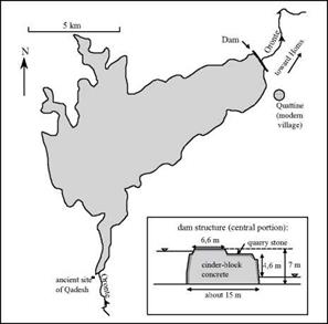
Development of the Roman OrientFigure 6.33 The lake of Homs (in 1932), a reservoir of about 90 million m3, and the structure of the ancient dam, after the measurements of L. Brosse in 1923 (Calvet and Geyer, 1992).

following Yves Calvet and Bernard Geyer, is that the site of the dam is a natural rocky barrier which, from very early times of Antiquity, was the site of structures built to raise the level of the natural lake. It is therefore probable that the Romans reconstructed or renovated an ancient dam at the time of Diocletius, following local rather than Egyptian practices, much as the modern dam is constructed over the Roman structure. The long life of the dam, and the fact that the impoundment is not filled with sediment, could be explained by the regular flow of the Orontes.

The Orontes is obviously a river that invites the development of hydraulic works, and it continues to do so as we discuss later in Chapter 7. But there is another region whose development necessitates important hydraulic projects: the region of Palmyra, a land of oases in the middle of the harsh desert of Syria, stopover of caravans on the silk road. Many small oases of Palmyra owe their prosperity to qanats. These could have been constructed by the Persians during the time of the Achaemindes Empire, but it is certain that the network of qanats is further developed and maintained by the Romans.[281] Even more spectacular in this region is the dam of Harbaqa, another project whose pur­pose is to create a reservoir of water for irrigation. The dam is constructed on a season­al watercourse, the wadi al-Barda, 70 km southeast of Palmyra.[282] With its height of 21 m and its length of 365 m, this is the largest dam of the Roman world (except possibly for the dam of Nero at Subiaco, which is higher). It constitutes a rectilinear wall whose thickness at the base is 18 m, further reinforced with buttresses. It is undoubtedly thanks

Development of the Roman Orient

Figure 6.34 In a land of minerals, the dam of Harbaqa across the valley of a Wadi. The impoundment is today completely filled in, but the dam enables the fill to retain sufficient moisture for farming. View from downstream (photo by the author).

to this solid construction that the dam remains standing today, minor repairs having been effected during the 1960’s (Figure 6.34). The dam was apparently built at the end of the 1st century or the beginning of the 2nd century AD as part of the infrastructural work ordered by Hadrian, who visited Palmyra in 130 AD. Much later, under the Umeyyades, new hydraulic works were built downstream of the dam of Harbaqa (Figure 7.10).

In closing this overview of hydraulic technology used in the Roman Orient, we must mention the technical consequences of a serious Roman defeat. When the Emperor Valerius is taken prisoner by the Sassanide Persians in 260 AD, the civil-engineering competence of the captured army is used to build several multi-purpose structures com­prising a dam-spillway and a bridge near the capital city Suse, on the Karun River and its tributaries. This was a kind of forced technology transfer.

Irrigation works in North Africa

Lucius Septimus Severus was born at Leptis Magna, capital of Cyrenaica (today’s Libya), at the end of the 2nd century AD. After the death of the Emperor Commodius in 192 AD, Severus emerges victorious from the civil wars, and becomes emperor in his turn, founding the dynasty of the Severians. North Africa had already been a prosper­ous region for some time; we have mentioned earlier the great aqueducts of Carthage and Cherchell (Lol Caesarea), testaments to the prosperity of these cities. But the new emperor adorns North Africa even further, battling the desert nomads, building roads and fortifications, and creating the new province of Numedia to the west of present-day

Tunisia. Severus had a natural attachment to his native country, but was also motivated by the desire to support new colonists and to create new lands for production of cereals to help feed the Empire.

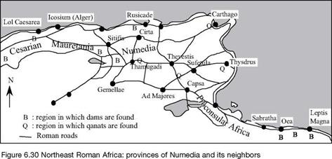
The Romans built some 130 dams for irrigation in North Africa, counting only those structures with known remains.[270] The dams were likely constructed in the 2nd century

Irrigation works in North Africa

AD (i. e. somewhat later than the dams in Spain). Some of the dams were intended to trap alluvial sediments and thus help create arable land, following the ancient technique of the Nabatians. One of these dams, near Leptis Magna, was built to divert flood waters of the wadi Labda, a watercourse at whose mouth the city’s port was developed (Figure 6.38). As far as we know, the highest of the dams was some ten meters; the longest is about 260 m. These are gravity earth dams, sometimes with buttresses, that can be sub­merged by violent floods of the wadis without suffering damage. Some 70 dams are thought to have been identified in the region of Leptis Magna and Tripoli (Oea); thirty in the region of Constantine (Cirta), Setif (Sitifis) and Rusicade; and fifteen around Cherchell (Lol Caesarea). The largest dam is that of Kasserine in Tunisia, on the wadi Derb, in a grain region not far from Sbeitla (Sufetula). This dam includes a wall 7 meters thick at its base and 4.9 m at its crest, 10 m high, and about 130m long. It has since been replaced by a modern dam on the same site.

There are also qanats in the Roman provinces of proconsular Africa and Numedia.[271] In North Africa, they are later called kettaras, or foggaras. We have seen in Chapter 2 how this technique was spread into numerous sectors of the Acheminides Empire by the Persians. We encountered it again in the oases of Egypt (Chapter 3). As we will see further on, it is obvious that the Romans maintained and developed qanats in the Orient. It is therefore no surprise that qanats are found in the eastern part of the African provinces: at El-Djem (Thysdrus), between Tebessa (Thevestis) and Gafsa (Capsa), near Carthage and, more to the west, in the region of Timgad (Thamugadi). The latter are attributed to the period of Commodius, i. e. the end of the 2nd century AD. Latin inscriptions sometimes attest to the Roman origin of the qanats, as in the region between Tebessa and Gafsa, or as at Timgad:

“Facility for the collection and delivery of underground water.”[272]

The Roman origin of the qanats is assumed in many other situations. The above observations make it tempting to accept the hypothesis of Henri Goblot, according to whom it was indeed the Romans who imported the qanat into Africa. Much later, the Arabs diffuse the technique even further, toward Spain and Morocco.

Mines and gold mining on the Iberian peninsula

Spain and Portugal are lands of mines during the Roman period: gold in the northwest, copper and silver in the southwest, silver in the southeast. Quite a panoply of hydraulic machines are used to evacuate water from deep galleries in the peninsula’s Roman mines: Archimedes screws, Ctesibios pumps, water wheels. Water is also used to wash sediments so that heavy metals, like gold and silver, can be settled out and recovered. This is the classic technique of gold miners working on rivers, a technique that has come down to us from Antiquity. After having visited silver extraction installations in the region of Cartagena (Carthago Nova), Strabo writes:

“[…] as for the silver ore collected, […] it is broken up, and sifted through sieves over water; that what remains is to be again broken, and the water having been strained off, it is to be sift­ed and broken a third time. The dregs which remain after the fifth time are to be melted, and the lead being poured off, the silver is obtained pure.”[267]

The exploitation of Spain’s richness in gold is of high importance to the Roman Empire since gold is one of the bases of its currency. In the northwest of the peninsula, there are huge surficial deposits of gold-bearing sediments from ancient river deposits, moraines, etc. Enormous quantities of water are needed to wash these sediments and remove the slag, and likely also to wash down entire hillsides of gold-bearing alluvial sediments. The necessary water is brought to the mining sites through a network of aqueducts and canals, sometimes supplied by the capture of rivers, and sometimes by dams. The water is typically stored in large reservoirs next to the excavation sites. Pliny the Ancient, who visited some of these sites (in the second half of the 1st century AD), was visibly impressed:

“Another labour, too, quite equal to this, and one which entails even greater expense, is that of bringing rivers from the more elevated mountain heights, a distance in many instances of one hundred milles perhaps, for the purpose of washing these debris. [….] The fall, for instance, must be steep, that the water may be precipitated, so to say, rather than flow; and it is in this manner that it is brought from the most elevated points. Then, too, valleys and cre­vasses have to be united by the aid of aqueducts, […] The water, too, is considered in an unfit state for washing, if the current of the river carries any mud along with it. The kind of earth that yields this mud is known as “urium;” and hence it is that in tracing out these channels, they carry the water over beds of silex or pebbles, and carefully avoid this urium. When they have reached the head of the fall, at the very brow of the mountain, reservoirs are hollowed out, a couple of hundred feet (c. 60 m) in length and breadth, and some ten feet (3 m) in depth. In these reservoirs there are generally five sluices left, about three feet (1 m) square; so that, the moment the reservoir is filled, the floodgates are struck away, and the torrent bursts forth with such a degree of violence as to roll onwards any fragments of rock which may obstruct its passage.”[268]

Remains of this system have been discovered in a region of the present province of Leon called La Valduerna. Claude Domergue describes a reservoir 170 m long, with a variable width from 33 m to 70 m and a maximum depth of 2.8 m, separated from upstream to downstream into two compartments of 3,500 m3 and 9,825 m3 in volume. Another reservoir of more than 10,000 m3 has been found in the same region, above a circular deposit some 2 km in diameter. Additional reservoirs that are more than 250 m long[269] have been found on the cliffs overlooking the mining sites.