Category Water Engineering in Ancient Civilizations. 5,000 Years of History

THE EMPIRES OF THE BUILDERS

For thousands of years, the hydraulic know-how of the East was no more than an oral tradition. But with the conquests of Alexander the Great, this oral tradition comes into contact with the Greek spirit of observation and analysis. The city of Alexandria, at the maritime front door of Egypt, for several centuries serves as the scientific center of the known world. The understanding and know-how of the scientists of the Alexandrian school remain unequalled during the following millenium, both in the East and the West, until the advent of the Renaissance.

Roman engineers, the inheritors of Etruscan and eastern techniques, influenced by the Greeks and endowed with a strong practical sense, leave the influence of their hydraulic achievements around the entire Mediterranean perimeter.

The fall of the Roman Empire ushers in the intellectual decadence of the West, but the East continues to develop up until the Mongol invasions of the 12th century AD. Then the East, in its turn, enters a period of profound reversal.

In China, whose hydraulic development began later, technical developments tran­scend the millennia up through modern times. The scale of these developments reflect the vast expanse of the country itself. From the 1st century BC through the 15th centu­ry AD, China serves as mankind’s principal nursery of technical innovations.

Meanwhile, during the Middle Ages the West even forgets that the earth is round. Nevertheless during the West’s demographic expansion of the 12th and 13th centuries, hydraulic development blossoms as lands are drained and mills are constructed.

Greek philosophers and thinkers of the classical era

The hydraulic works of Greece during the classical era do not measure up to those of the Mycenaen era. The few extracts cited above also show that in Greece, hydraulic know-how lags behind that of the Orient. And yet this classical Greece is known to us as the privileged cradle of development of philosophical and mathematical thought. Two facts are important in this regard. First, Greek science at this period took it as a point of honor to be disconnected from engineering, i. e. not to be associated with prac­tical applications. Second, and it is here that one can effectively and for perhaps the first time refer to science, the “sages” sought to apply reasoning to the explanation of great natural phenomena.

Such explanations of natural phenomena are often incomplete, and sometimes false. Regarding the hydrologic cycle, the brilliant mathematician and astronomer Thales of Miletus (610 – 545 BC?) – who had established that the world is round – postulated that water is the primordial substance and that the land masses float upon it. This is a theo­ry perhaps inspired by the ancient Mesopotamian and Egyptian cosmologists. Later, Anaximandre of Miletus (610 – 545 BC) identifies the origin of precipitation as water torn from the earth’s surface by solar action. Xenophane of Colophon (570 – 475 BC?) writes that the sea, source of all water, is also the origin of clouds and winds, that fresh water comes from evaporation of the sea, that rivers result from rain, and that it is by rinsing the ground that watercourses carry salt to the sea. The hydrologic cycle is there­fore fairly well understood in Greek civilization of the 6th century BC, except for the role of groundwater. Indeed, during this period it was thought that the water in springs and wells comes from the sea.

Plato (427 – 347 BC?) adopts the idea, articulated before him by Empedocle of Agrigente, of the four primordial elements: water, air, fire, and earth. His student Aristotle (385 – 322 BC), born in Macedonia, frequents Plato’s Academy until the death of the master, and becomes preceptor of Alexander at the court of Philippe of
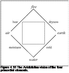
Подпись:Macedonia. At Athens he creates the institution called the Lyceum. Aristotle in his turn adopts the theory of the four ele­ments, a theory that will remain a standard reference until the Middle Ages. He believed that each of these elements tends to return to its natural place, e. g. water below the ground, air above water, etc. Thus, for Aristotle, wood floats because it contains air, and it is in the natural order of things that air be above water. To each element is attributed two of the four fun­damental “qualities”: cold, moistness, heat, and dryness (Figure 4.16).

Attempts to explain nature from such a postulate can obviously lead to absurd con­clusions. Here is how Aristotle, reflecting his ignorance of what we now call inertia, shows in his Physics that a vacuum cannot exist, and in so doing sets down an absurd theory of wind resistance. First, in virtue of the natural “position” of each element, as we have seen above, if an object (for example a stone thrown by a man) moves through the air, “outside” of its natural position, there is an action, a “motor” that sustains its movement:

. .earth and all other bodies should remain in their proper places and be moved from them only by violence. J

Then, since “it seems that everything in motion is impelled by something”, the stone that continues its movement through the air must be sustained, in its movement, by the air itself:

”(…) things that are thrown move (although that which gave them their impulse is not touch­ing them, either by reason of mutual replacement, as some maintain, or because the air that has been pushed pushes them with a movement quicker than the natural locomotion of the projectile wherewith it moves to its proper place.”[161] [162]

Aristotle continues his demonstration in postulating that in a vacuum, all movement would be impossible – i. e. in the absence of this air that “maintains” movement. Therefore “there is no vacuum separate from things”.

At about this same time Pytheas (380 – ? BC), of the Phoenician colony of Massalia (Marseilles), sets out on a voyage that leads him to the great north, probably as far as Iceland. During this voyage he establishes a correlation between the periodic phenom­enon of the tides and lunar cycles.

Overall, one can only admire this quest for truth as representing progress and prom­ise for the future. Yet it is also clear that during the Greek classical era, hydraulic the­ories are, at best, rudimentary. It is not until the Hellenistic period and the intellectual movement coming out of the school of Alexandria that mathematics and the faculty of reasoning lead to practical innovation.

Engineering projects developed in Greece by the Persians during the Median wars

Herodotus’ history of the Median wars is interesting for its representation of the first confrontation between the classical Greek world and the Orient. Certain elements of Herodotus’ writings show the technical and cultural abyss that separated the two civiliza­tions, both in their relationships to the sea and their practice of fluvial engineering.

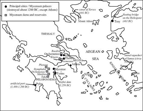
During the first Median war, the Persian fleet suffered major losses during its pas­sage around Mount Athos, a cape that extends quite far into the northern portion of the Aegean Sea (see Figure 4.6). Anticipating the second war, king Xerxes spent three years, according to Herodotus, digging a canal to get around the mountain on the land side of the isthmus. Here is how the historian describes the organization of the project: “(…) a line was drawn across by the city of Sand; and along this the various nations parceled out among themselves the work to be done. When the trench grew deep, the workmen at the bottom continued to dig, while others handed the earth, as it was dug out, to labourers placed higher up upon ladders, and these taking it, passed it on farther, till it came at last to those at the top, who carried it off and emptied it away. All the other nations, therefore, except the Phoenicians, had double labour; for the sides of the trench fell in continually, as could not but happen, since they made the width no greater at the top than it was required to be at the bot­tom. But the Phoenicians showed in this the skill which they are wont to exhibit in all their undertakings. For in the portion of the work which was allotted to them they began by mak­ing the trench at the top twice as wide as the prescribed measure, and then as they dug down­wards approached the sides nearer and nearer together, so that when they reached the bottom their part of the work was of the same width as the rest. J

The Greeks, given their familiarity with the sea, would never have built such a canal to avoid sailing around a dangerous cape.

During the military campaign that ensued, king Xerxes had reason to be astonished at the Greeks’ lack of experience in large hydraulic works. To Xerxes, relocation of a river for military purposes is a classic maneuver, as seen in his analysis of the vulnera­bility of Thessaly, in the north of Greece:

“When Xerxes came and saw the mouth of the Peneus, he was in great amazement, and, sum­moning his guides, he asked them whether it was possible to turn the river aside from its course and lead it into the sea somewhere else.

“’They are clever men, the Thessalians (said the King). This is why they took their precau­tions long ago and conceded victory to me; it was especially because they have a country that is easy and quick to capture. It would only be a matter of letting the river in upon their country by shifting it out of that channel and turning it from the course in which it travels with a dam, and all of Thessaly, except the mountains, would be beneath the waves’.”

The floating bridge that Xerxes cast across the Hellespont for passage of his immense army must also be included among the many great hydraulic works of the Persians during the second Median war. [159] [160]

The hydraulic works of Samos: record achievements in the Greek world

The city of Samos in Ionia is located near the coast of Asia Minor on an island of the same name. A spectacular tunnel more than 1,000 m long was dug for its water supply (Figure 4.15). The tunnel was bored in two sections starting from its extremities (the meeting point of the two bores is shown by an arrow on Figure 4.15). The water supply conduit was laid at the bottom of a trench dug into the floor of the tunnel. Because of this trench, it was possible to dig a horizontal tunnel (a relatively straightforward task); the depth of the trench is zero at the entrance to the tunnel and progressively increases to reach nearly 8.5 m at the tunnel’s exist, assuring the slope necessary to convey the flow.

The hydraulic works of Samos: record achievements in the Greek world

Figure 4.15. Plan view of the aqueduct of Samos and the tunnel of Eupalinos.

Herodotus considered this project, which is still partially visible today,[157] [158] as one of the marvels of the Hellenic world:

“I have dwelt the longer on the affairs of the Samians, because three of the greatest works in

all Greece were made by them. One is a tunnel, under a hill one hundred and fifty fathoms

(265 m) high, carried entirely through the base of the hill, with a mouth at either end. The

length of the cutting is seven furlongs (1,240 m) – the height and width are each eight feet (2.4

m). Along the whole course there is a second cutting, twenty cubits deep (8.5 m!) and three

feet broad (0.9 m), whereby water is brought, through pipes, from an abundant source into the

city. The architect of this tunnel was Eupalinus, son of Naustrophus, a Megarian. Such is the

22

first of their great works; (….)”

Herodotus’ dimensions approximately coincide with those that can be deduced from the remains of the works. The project was very likely undertaken under the reign of the tyrant Polycrates, around 530 BC, before Samos fell under Persian domination.

Herodotus also mentions a mole (breakwater) at the port of Samos, once again a record achievement for the period. Here is the continuation of the passage above:

“the second is a mole in the sea, which goes all round the harbor, near twenty fathoms (35 m) deep, and in length above two furlongs (355 m). The third is a temple (..)”

Water supply for Greek cities

Greek cities develop their water supply using local springs and aqueducts of terra-cotta conduits, following the centuries-old Cretan and Mycenaen traditions. These conduits are set underground, both for their protection and to accommodate irregular topography.

They are assembled from interlocking pre-fabricated elements from 60 cm to 1 m long, and between 11 and 22 cm in diameter.[156] Some of the individual elements have a hole in their crown, normally plugged with clay, very likely intended to provide access for inspection and cleaning of the pipes. The presence of these inspection holes, as well as the thinness of the walls (2 to 4 cm), clearly suggest that these pipes conveyed water through free-surface gravity flow, not under pressure.

The Greek world in the classical age

With the disappearance of the Mycenaen civilization, Greece enters its dark age. For no less than four centuries writing is forgotten, not to be rediscovered until the 7th century BC with the adoption of the Phoenician alphabet of the 10th century BC. In the 5th cen­tury BC, Greek history is punctuated by the revolts of the Ionian cities against the yoke of the Persian Achaeminides; then by the Median wars with two Persian invasions in continental Greece; then by internal struggles (the Peloponnesian war). Travelers, sometimes imbued with a sense of Hellenic superiority, but also sometimes remarkably open and observing like Herodotus, open the eyes of the Greeks to Egypt and the Orient.

These “tourists” were not all peaceful; Xenophon and the successful of the Ten Thousand may have inspired the subsequent invasion of Alexander. These centuries also witness the expansion of the Greeks toward the west, with the founding of Marseilles (about 600 BC) and with the founding of Greek colonies in Sicily and the south of Italy toward the end of the 5th century BC. This expansion formed a cultural ensemble today called greater Greece.

A dam to protect Tiryns

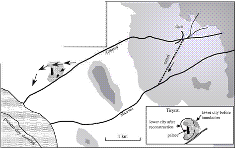
A catastrophe strikes the city of Tiryns toward the end of the Mycenaen civilization. The city is located on an alluvial plain about one kilometer from the sea; the palace is 24 m above sea level, on a limestone hill. The city itself is at the foot of the palace, to the east and south. The watercourse along which the city is located, the Lakissa, leaves the mountains on a steep slope of nearly 15 m/km as dictated by the local topography.

Levees normally protect the city from the caprices of the river. But in about 1200 BC, at essentially the same time that the nearby city of Mycenae and its palaces were destroyed and burned, an exceptional event occurred. The Lakissa River left its bed, flowed to the north across the lower city, and covered most of the city with a thick layer of sediments, as much as 4 m deep in places. Only the palace on its hill in the southern part of the city was spared the effects of the deluge. This event could have been caused simply by an exceptional flood, or more likely by a major earthquake, the same one that destroyed Mycenae. Such a quake could have caused the collapse of the riverbanks causing a wave of debris-laden water rushing down the steep slope of the riverbed.[154]

A dam to protect Tiryns

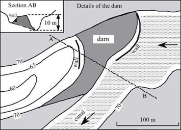
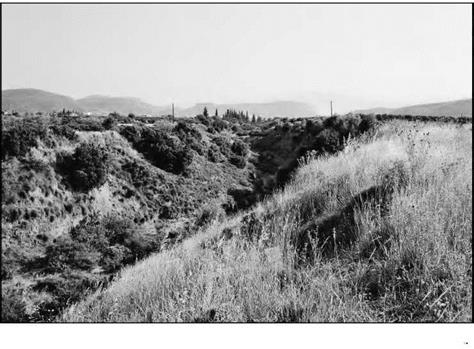
But this event did not mark the end of the Mycenaens. To protect the city from the Lakissa, they built a dam 3.5 km upstream to divert waters of the Lakissa into a 1.5 km canal for conveyance to another watercourse, the Manessi, that flows more to the south (Figures 4.12, 4.13 and 4.14). This 10-m high dam, extending 57 m and 103 m across the left and right banks, respectively, is built of earth fill between two walls of the same type of cyclopean masonry[155] that is used in other Mycenaen works. The lower city is rebuilt on top of the sediments that buried the old city, eventually occupying about the same overall area as before (see inset in Figure 4.12).

Подпись: Figure 4.13 The Kofini dam for protection of the city of Tiryns against floods of the Lakissa (present-day situation) - Zangger, 1994.
A dam to protect Tiryns

A dam to protect TirynsFigure 4.14 Lakissa diversion canal, looking from the top of the Kofini dam (photo by the author)
This account illustrates the kinds of natural catastrophes that, in the troubled climate of the years around 1200 BC, may have contributed as much to the destruction of the palaces as did the Dorian invaders. Nonetheless, the Mycenaen civilization was still strong enough to implement the hydraulic works that returned the city of Tiryns to safe­ty. A century later this civilization of Nestor, Menelaus and Agamemnon, warrior-
builder descendents of the Minoans, does finally succumb to the overwhelming pressure of the Dorians, leaving only legends behind.

Drainage and land improvement in the Mycenaen civilization

Many of the regions of Peloponnese or Attica are karsitic. Entire rivers disappear into abysses or caverns (called catavothres in Greek), only to reappear at some distant point.

When the subterranean cavities fill up or are blocked, for example after earthquakes, water can accumulate in marshes and lakes, the water level varying from season to sea­son and from one period to the next. Strabo describes these phenomena:

“Some of these plains are marshy, since rivers spread out over them, though other rivers fall into them and later find a way out; other plains are dried up, and on account of their fertility are tilled in all kinds of ways. But since the depths of the earth are full of caverns and holes, it has often happened that violent earthquakes have blocked up some of the passages, and also opened up others, some up to the surface of the earth and others through underground chan­nels. The result for the waters, therefore, is that some of the streams flow through under­ground channels, whereas others flow on the surface of the earth, thus forming lakes and rivers. And when the channels in the depths of the earth are stopped up, it comes to pass that the lakes expand as far as the inhabited places, so that they swallow up both cities and dis­tricts, and that when the same channels, or others, are opened up, these cities and districts are uncovered; and that the same regions at one time are traversed in boats and at another on foot, and the same cities at one time are situated on the lake and at another far away from it.”[151]

To be arable, these valleys had to be drained and the lake levels stabilized. The most important of such efforts were developed in Beotia by the Mynians (subjects of the king Mynias), near Orchomenos, their capital. The memory of Mynian power and manage­ment of the lake Copais was still fresh at the time of Strabo:

“They say that the place now occupied by lake Copais used to be dry, that it then belonged to the Orochomenians, their close neighbors, and that all sorts of crops were grown there. Here one sees an additional confirmation of the wealth of this city.”[152]

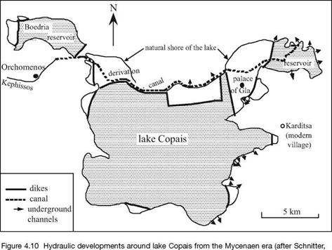
Lake Copais is fed by runoff from rainfall and by the Kephissos river. The natural grottos already mentioned, i. e. catavothres, were used to drain it to the sea.[153] The waters of the Kephissos, previously flowing into the lake, were detoured to an under­ground passage through a 25-km long canal. The canal may have also been used for nav­igation. The land reclaimed by emptying of the lake was itself drained, surrounded by protective dikes, and brought under cultivation. Water from what remained of the lake provided irrigation for these lands. The Mynians built the palace of Gla (Homer’s Arne) in one area reclaimed from the lake, in the middle of the depression. The lake, now fed only by runoff from rainfall, was nearly dry in the summer, so that part of its bed could also be cultivated. Figure 4.10 is a map of developments around the lake that were very likely in operation about 1300 BC. With the end of the Mycenaen civilization, the lake’s systems were no longer maintained, and the marshy lake reestablished itself. Between 334 and 331 BC one of Alexander the Great’s engineers, a certain Crates of Chalchis, again set out to drain and dry the lake. But these efforts were not completed, either because of technical difficulties in the region or some other troubles.

Drainage and land improvement in the Mycenaen civilization

1994).

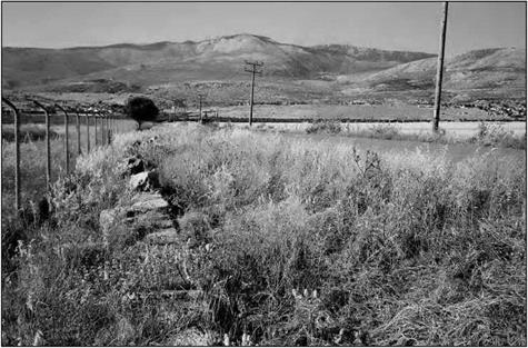
These same techniques are used to reclaim marshy valleys in many other locations. Typically there are dikes surrounding a reservoir-lake fed by rainwater and snowmelt, the dikes also serving to protect dry areas that are drained into grottos or caverns. Eight such reservoirs, including the Boedria reservoir shown in Figure 4.10, are listed in table 4.1. Five of these sites are in Peloponnese (Figure 4.6). For all of these projects, the dikes are between two and four meters high, and of variable length from 200 to 2,500 m. They most often are built of earth fill between two exterior walls. Some of these dikes are still visible today (Figure 4.11).

Table 4.1 Mycenaen dam-reservoirs (after Knauss, 1991; Schnitter, 1994)

Name

(see Figure 4.6)

Height

(m)

Length

(m)

Reservoir Volume

(million m3)

Boedria

2

1,250

24

Kineta (Thisbe)

2.5

1,200

4

Mantinea

3

300

15

Orchomenos

2

2,100

16

Permessos

4

200

2

Pheneos

2.5

2,500

19

Stymphalos

2.5

1,900

9

Takka

2

900

9

Drainage and land improvement in the Mycenaen civilization

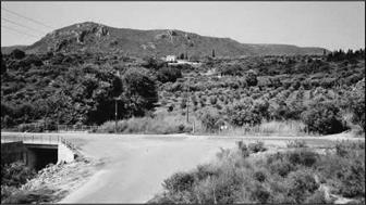
Figure 4.11 Remains of the Kineta dam (Thisbe), 1,200 m long. The modern road was built on top of the ancient dam; at the left, remains of the wall of large cut stone (photo by the author).

Port development at Pylos

Between 1400 and 1200 BC, Achean shipping dominates long-distance commerce in the eastern Mediterranean, extending to Sicily, and perhaps even as far as to Spain. The ports of Antiquity are often developed in natural bays (that do not always provide good shelter), or in river mouths.

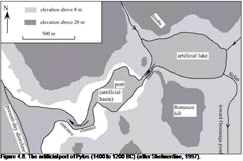
Recently, a detailed study of the Pylos region has made it possible to reconstitute the development of an artificial port.[150] This port was created by excavating a closed basin into marine sediments, and linking it to the sea through a channel (Figure 4.8, 4.9). The sinuous path of the channel keeps ocean swells from entering the port itself.

The port would rapidly have become unusable without additional engineering efforts, either due to silting-in of the basin itself, or by the blocking of the entrance chan-

Подпись: Figure 4.8. The artificial port of Pylos (1400 to 1200 BC) (after Shelmerdine, 1997).

nel by wave-transported sand. A through-flow was necessary to keep the port open, as would be the case in the natural estuary of a river. Therefore a river called the Selas, nat­urally flowing into the Osmanaga pond to the south, was relocated so that part of its flow, very likely controlled, passed through the port on its way to the sea. An artificial lake, linked to the port by a canal dug through a rocky barrier, served as an intermediate stor­age and settling basin for the river flow.

Подпись: Figure 4.9 The site of the ancient port of Pylos from the heights to the east of the entrance canal, looking to the north; the flat area with the orchard is the ancient basin of the port (photo by the author).
Port development at Pylos

Study of the history of sedimentation in the Osmanaga pond enables us to date this wonderful project to about 1200 BC. Such analysis also suggests that after the destruc­tion of Pylos, in about 1200 BC, the totality of the river flow takes the direct path to the sea through the port.

Urban hydraulics in the Mycenaen palaces

The centers of Mycenaen power are in strongly fortified palaces (Figure 4.6), with an architecture that has been described as cyclopean due to its use of huge stone blocks. At Mycenae in the palace of Agamemnon, at Pylos homeland of Nestor, and at Tiryns, one finds bathing rooms equipped with permanent bathtubs of terra cotta that sometimes

Urban hydraulics in the Mycenaen palaces

Figure 4.6 Sites of the great hydraulic developments in the Greek world before Alexander.

were equipped with a drain. Complex systems of drainage sewers in the floors of the palace drained both rainwater and wastewater, including water from the bathing rooms. At Pylos, stone drains collect wastewater and dump it into collectors large enough for a
man to stand in.[148]

Like the Cretans, the Mycenaens bring water to their palaces using aqueducts. At Pylos, it is thought that a two-kilometer aqueduct brings spring water to the palace; part of the aqueduct is made of terra cotta in the shape of a U; another part is made of wood; and

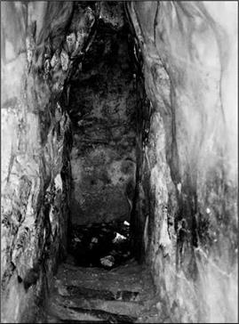
Urban hydraulics in the Mycenaen palacesyet another part is incised into the rock. At Mycenae, an underground cistern is accessed from the citadel by going down three flights of stairs that pass under the outer enclosure wall. This cistern is fed by a rock tunnel that brings distant spring water to it (Figure 4.7).[149]

Figure 4.7 The underground cistern of the palace of Mycenae (photo by the author).