Relation Between Road and Groundwater
According to the literature, various definitions of groundwater exist. For some authors, groundwater is defined as water only in those pores that are completely
saturated, but for others a more general definition is acceptable with the groundwater being all the water below the ground surface either in the saturated or in the unsaturated part.
A geological medium containing groundwater is defined as an aquifer. Aquifers can be described as rock or soil (sediment) of high permeability that are able to store and transmit significant quantities of groundwater. In hydrogeological terms, the limit between an aquifer and less permeable geological media is frequently defined with a coefficient of permeability, K, of 10-6 m/s.
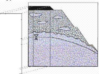
Figure 2.2 shows a schematic view of the regions of subsurface water in a pavement structure. The upper part represents the unsaturated or the vadose zone and the lower part represents the saturated or the phreatic zone. The groundwater table, defined as the surface where the water pressure is equal to the atmospheric pressure, separates them. The water content within the vadose zone is at saturation near its base while at its upper extent it is dependent on the characteristics of the soil. The vadose zone is divided into:
• a capillary zone. Above the groundwater table is the capillary zone or the capillary fringe because water is pulled upward from the water table by surface tension. The capability is linked to the pore size distribution of the material, the smaller the pores the greater the extent of the capillary rise. The thickness of the capillary fringe can vary from a few centimetres in coarse grained soils to a few metres in fine grained soils. The pores are saturated but the water pressure is less than atmospheric.
•
 |
 |
an intermediate vadose zone. The second sub-region of the vadose zone is the intermediate vadose zone where water is held by capillary forces. In sealed pavements in good conditions, the surface layer is relatively impermeable and the water held here should be relatively stable with water content at or near
field capacity (the remaining water content held by a soil after it has been allowed to drain freely), but through spring thaw or wet periods water could migrate inwards from the shoulders resulting in temporary higher water contents. In cracked pavements, on the other hand, water can move downward from the surface through the intermediate vadose zone to the capillary zone resulting, spatially, in periods of higher water content than the field capacity stipulates.
• a surface water zone. The layer closest to the surface is the surface water zone. Again, as for the intermediate vadose zone for sealed pavements in good conditions the water content should be relatively constant close to the field capacity or lower depending on atmospheric conditions. In cracked pavements on the other hand water can enter to the granular layer through cracks or other openings during periods of rainfalls and part of the layer may, therefore, include high water content or even become fully saturated.
In the unsaturated zone pore spaces are only partially filled with water and the direction of the groundwater flow is predominantly vertical. In the saturated zone, pores are completely filled with water and groundwater flow is nearly horizontal. The saturated aquifer zone is underlain by a low permeability basement stratum, known as the confining bed, which acts as a hydrogeological barrier. This is a necessary condition for the aquifer existence: without the barrier there would be no saturated zone.


Leave a reply