The pharaoh and the lake: the great hydraulic works of the IInd millennium BC
In prehistory the Joseph canal, or Bahr Youssouf, supplied water to Fayoum through an ancient arm of the Nile. At that time Fayoum comprised an immense body of water and marshes, with a water surface elevation somewhat below that of the Nile. Little by little, sedimentation raises the elevation of the plain. In about 7500 BC, hydraulic con
nection of the region to the Nile is not continuous but episodic, causing periods of rising and falling lake levels. Throughout the IIIrd millennium BC, the lake level appears to have remained low, at an elevation that is thought by some to be around -2 m,[106] the level of the Nile being around +20 m at this time. At this time the large lake was natural, occupying roughly the area within the contour 0 on Figure 3.6. The lake supported fishing, and hunting along its shores.
About 2000 BC, possibly because of an exceptional flood, the water level in the Fayoun Depression abruptly rose to +22 m, and then fell again.[107] This surge of water inundated Kasr el Sagah (founded about 2400 – 2300 BC) where there was an embarkation embankment. After this episode, men started to have a hand in the evolution of the lake, at the height of the Middle Empire. About 1890 BC, Sesostris II begins the extensive work that is eventually finished 50 years later by his grandson Amenemhat III,[108] the sovereign whom the Greeks later called Moeris.
|
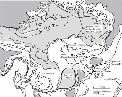
Figure 3.6 The Fayoum Depression and the “Moeris Lake”. We have shown on this map the 0, 10, 20, 30, and 50 m contours, from Ball (1939), as well as monuments and establishments of the XIIth Dynasty. Also shown are the hydraulic works (the Illahoun dike and the Mala’a reservoir) which have been dated in the 3rd century BC (Garbrecht and Jarritz, 1992). The normal level of the Nile is today at an elevation of 23 m; the flood level can attain 30 m. |
The work included widening the Joseph canal to 90 m, and building other irrigation and drainage canals. As a result, the now-cultivated region became an important economic center. The irrigation system undoubtedly used flood storage basins, as was the practice in Egypt. It is easy to suppose that the large artificial reservoir later recognized as Mala’a occupied the upper terraces to the south of the depression in one form or another, at an elevation sufficient to supply water to all of the region (there is no proof of this, however).[109] The capital of the Lake Province was then called Shedet (today Medinet el Fayoun), a city the Greeks will soon call Crocodilopolis since crocodiles are worshipped there. Amenemhat III had a tomb built so he could forever remain there, at Hawara. This is a pyramid associated with a vast temple called the labyrinthe, much admired by Greek and Roman tourists. This same king had a temple built near the present Medinet Madi, and another in the reconstructed colony of Kasr el Sagah. He also built two colossal statues at Biahmou, each twelve meters in height on a monumental pedestal, undoubtedly in his own image.
|
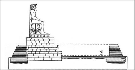
Figure 3.7 Amenemhat III looking over the Moeris lake – reconstitution of one of the colossi of Biahmou by the Egyptologist Sir Flanders Petrie (1899) (after Lane, 1985). |
The Ptolemaic assertion that there were water control works at the entrance of Fayoun in this period (the Illahoun dike and its gates) has always been subject to some doubt. Yet one can see on Figure 3.6 that the monuments of the XIIth Dynasty are at an altitude of between +10 m and +20 m,[110] i. e. quite some distance below the flood level. Therefore it is easy to suppose that there must have been hydraulic works at Illahoun to isolate Fayoun from the rest of the valley and control the inflow of the Nile into the depression.
With the end of the XIIth Dynasty and of the middle Empire, in 1759 BC, came the troubles of the second intermediate period. During this period the maintenance of the Fayoun system was surely neglected. There is geological evidence of major inundations around 1700 BC, when the water level in the Fayoun Depression reached +22 m. Then again in 1500 BC it reached a record elevation of +24 m.[111] These floods were highly destructive, and the region never recovered its previous glory (at least not before the new developments of the 3rd century BC). Still, the region partially recovered in the period of the Ramses, when Fayoun hosted the great royal harem. A new series of troubles began in the 9th century BC, and with them surely came more uncontrolled incursions of the floods of the Nile into the Fayoun Depression. According to Butzer (1998), the water level in the Fayoun remains around +20 m from the 9th to the 5th century BC. It is easy to see from Figure 3.6 that the quasi-totality of the depression would be flooded at this level.


Leave a reply