The Nabatians of Petra, hydraulicians of the desert
Antigonus, the old one-eyed general of Alexandria, sought to solidify its domain in the Near East, between the domains of Ptolemy in Egypt and that of Seleucos in Mesopotamia. He coveted the wealth of the semi-nomad “barbarians” who frequented the routes of caravans carrying spices, myrrh, and incense from Maryab in Arabia Felix, to the south of the Dead Sea. In 312 BC, he sends his friend Athenes on an expedition toward the “formidable citadel”, the “rock” (petra in Greek) where these “barbarians” store their riches. Athenes does not come back alive. Antigonus then sends his son Demetrius to lay siege to Petra, again without success. Later, the Seleucids, new masters of Syria, attempt the same exploit and also fail. These “barbarians”, objects of such envy for the successors of Alexander, call themselves the Nabatu. They likely came from central Arabia in the 5th century BC, and settled peacefully in the south of Palestine, left unpopulated by the deportation of the Assyrians and the Babylonians.
The Nabatian civilization becomes sort of a synthesis of the civilization of the ancient East and the new Hellenistic influences, since some degree of normal exchange continues during the wars with the Seleucids. Its golden age is at the very beginning of the Christian era before the Romans, new masters of Egypt, establish a direct maritime route toward the land of incense through Alexandria and the port of Myos Hormos on the Red Sea. In 106 AD, on the orders of Trajan, the kingdom of the Nabatians is peacefully integrated with the Roman Empire, henceforth becoming the province of Arabia. The prosperity of the Nabatians is founded not only on the spice trade, but also on the technical prowess that enables them to farm the desert. This echoes the situation of the kingdom of Sheba, as we discussed in Chapter 3. Here, the main problem is to create arable land in the mineral wasteland of rocks and stones of the Negev desert. Weirs that partially block watercourses retain not only the annual floodwaters, but also and perhaps more importantly, they retain the silt conveyed by the floodwaters. This silt, accumulated flood after flood, creates lands that eventually can be cultivated. This technique is surely inspired by earlier practices in Arabia Felix. But the reader may also recall the very ancient developments of Jawa and Khirbet el-Umbashi, in the Syrian-Jordanian desert (Figures 2.6 and 2.8). The technique will later be used by the Romans for the development of North Africa.
Under Nabatian control, the Negev becomes a land of immense orchards, farms, and villages, with roads, numerous water mills, and even cities like Oboda (today Advat) and Mampsis (Kurnub).
If Petra, the capital, is able to resist all attempts at conquest, it is because it is located on a site that is a natural fortress. The city is constructed in the valleys of the wadis, and served, thanks to the Nabatian techniques, by small dams. It is deeply entrenched in a tall sandstone massif, contoured by the combined actions of water and wind:
“The capital of the Nabatians is Petra; this is what it is called, for it is situated on a site that
■ wadis
deviation of the wadi Musa flood altitude above 950 m altitude above 1000 m (800) altitude in m A principal rock monuments
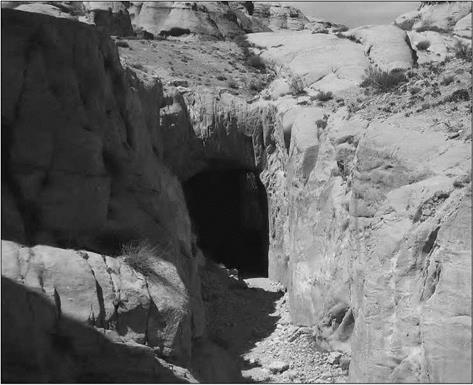
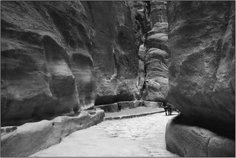
The site is accessible only through narrow gorges. The main route for access and communication, called Siq, is the gorge through which the Musa wadi, whose source is several kilometers to the east, penetrates the massif. This gorge is 1,500 m long, but only several meters wide (sometimes less than 3 m), and about a hundred meters deep. The wadi is usually dry, but the winter flood can be very sudden. To keep the Siq safely dry, once it had been transformed into a paved road, the Nabatians constructed a dam on the Musa wadi at its entry into the narrowest portion of the gorge. They also construct a tunnel, 9 m high and 6 m wide and 88 m long, to redirect the flood waters toward the el – Mudhim wadi, then toward the el Metaha wadi, the flood waters rejoining their natural course at the city center (Figure 5.13).
This proj ect was very likely built at the beginning of the 1st century BC, at the same time as the planning for the urbanization of the city. The dam itself is 14 m high and 43 m long. The violence of the torrential rain, combined with the slope of the gullies and [196]
wadis (the bed of the Musa wadi, itself, has in the Siq a steep slope, around 40 m per kilometer), explains the rapidity of the floods. A recent hydrological study estimated that the maximum discharge of the Musa wadi flood must be about 200 m3/sec, reached in only one hour.[197] This dam was reconstructed in 1964, following the death of 24 tourists carried away by a sudden flood. Since then, the floodwaters have again drained through the Nabatian tunnel.
The city’s water supply is provided by aqueducts as well as by extended systems of dams, canals, reservoirs and cisterns collecting stormwater runoff. The first aqueduct was a channel which captured the spring water of the Musa wadi valley, and was built in the beginning of the 1 st century BC, then destroyed by a flash flood of the Musa wadi. It is rebuilt in the third quarter of the 1st century BC as a terracotta conduit following the right wall of the Siq, and complemented by the end of the 1st centuryAD by five other aqueducts, including a second aqueduct in the Siq (see photo fig5.13c), carved along the left wall of the Siq (Bellwald, 2006).
|
Figure 5.13b. The tunnel constructed by the Nabateans to redirect the flood waters of the Musa wadi towards the el-Mudhim wadi. The tunnel is, at its entrance, 9 m high and 6 m wide (photo by the author). |
|
Figure 5.13 c. The Siq, which is the main access route to Petra, and which was the course of the Musa wadi before the dam and tunnel were constructed. On the right, the channel containing the terracotta aqueduct (dated by 25 BC), and on the left the channel of the other aqueduct constructed in the middle of the 1st century AD (photo by the author). |


Leave a reply