On the steppes of central Asia: Irrigation in Bactria and Margiana before the arrival of Alexander the Great
Bactria, to the east of the Zagros mountains and the Iranian plateau, is connected to the Syro-Mesopotamian world through a continuous thread of ancient exchanges, and thus it also must be mentioned in this chapter. Bactria was a land of plenty and fertile valleys as noted by Strabo:
“Man has only to take the trouble to irrigate, and all crops grown abundantly with the excep – 53
tion of the olive tree”.
In Chapter 1 we mentioned the appearance of the Bactria-Margiana civilization, or the Oxus civilization, for which the mastery of irrigation is a fundamental pillar. It is doubtful that Bactria ever really fell under the Assyrian yoke, as is suggested in certain ancient sources. To the contrary, it was clearly part of the Achaemenid Persian Empire, and therefore belongs on the list of conquests of Alexander – but not without combat. Indeed, it was at Bactria that Alexander married Roxanne.
Successive hydraulic developments in the region became more and more generalized from the IVth millennium BC. In Margiana and western Bactria, rivers that used to disappear into the desert before reaching the Oxus River form deltas that are developed and irrigated in the IInd millennium BC. Among the oases on the deltas are those of Geoksiur (mentioned in Chapter 1), Merv (Marw) on the Murgab River (to be discussed further in Chapter 7), Sherabad, Ulambulak and Mirshada on the right bank of the Oxus in western Bactria, and Bactra (Balkh) to the south, capital of the region toward the end of the IInd millennium BC. Russian archaeological studies have shown that at Merv, [84]
|
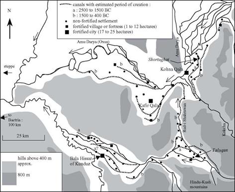
Figure 2.20 Irrigation canals in eastern Bactria on the eve of the arrival of Alexander the Great, near the confluence of the Oxus and the Kokcha (Gentelle, 1989; Gardiun, 1998). The irrigated fields are located between the canals and the rivers. The sites shown in italics (Shortughai and Taluqan) date from the IIIrd millennium BC. |
habitation progressively migrates upstream as aggressive irrigation starves the downstream extremities of the network.54 In Sogdiana to the north, one can also find remnants of early irrigation at Sarazm, on the Zeravchan River (the watercourse on which Samarcand is later founded). One also finds such traces on the lower course of the Oxus, to the southeast of the Aral sea, and at Dehistan, to the southeast of the Caspian (see Figures 1.3 and 7.1 for location maps).
Irrigated agriculture develops naturally in the valleys of the Oxus and its tributaries in western Bactria, at the foot of the great mountains of Hindu Kush and Pamir. French explorations conducted between 1971 and 1977 led to restitution of ancient canals, and helped establish a chronology of their evolution based on the dates of inhabited sites.[85] As agriculture spread to terraces situated higher and higher above the rivers, it was necessary to extend the canals so their intakes would be higher than the irrigated land, and to route the canals from one terrace to another. Often it was necessary to supply a canal from a tributary of the main river, sometimes far away, to bring water to the irrigated terraces along the main river itself. For example, a plain that overlooks the Oxus at its confluence with the Kokcha was irrigated from the IIIrd millennium BC by a 25-km long canal fed by the Kokcha itself, and extending down to the Harappan settlement of Shortughai (Figures 2.20 and 7.2).
But even larger water resource developments appeared during the period from 1500 BC to the arrival of Alexander the Great – a period that also saw the development of major water supply in Assyria and Urartu. An artificial branch of the Taluqan River was excavated to develop the left-bank region of the Oxus, proceeding to the north against the natural drainage (Figure 2.20). This 50-km branch is today called the Rud I Sharawan. That the canal is artificial can be seen from its often perpendicular orientation compared to the natural drainage. To the south, it follows the paths of old river arms or canals in the Taluqan plain; and to the north, it follows the valley of a small tributary to the Kokcha. The canal is deeply entrenched into unstable loess in its central portion that separates the drainage basins of the two rivers, attaining a depth of as much as 20 meters along one kilometer.
This is a significant operation of inter-basin water transfer, comparable to that implemented by Sennacherib to bring water to Khosr and Nineveh (Figure 2.15). Although it is impossible to say which of these developments came first, the necessary know-how clearly existed in both of these widely separated regions. What could have been the driving force for this project in Bactria: the decision of Persian leaders or the earlier work of a local Bactrian authority? Bactria had a strong cultural unity even before the arrival of the Persians. It may also have had strong political unity, but its history is unknown.


Leave a reply