GEOMETRIC DESIGN
Once a route has been selected for a new highway, or a decision has been made to perform major work on an existing facility, the next step is to establish the design controls. The various factors considered for design controls may be generally grouped into five categories: functional classification, traffic data, terrain, locale, and design speed.
Functional classification is a way of grouping roadways together by the character of service they provide. The initial division is between urban and rural roadways. The urban classification may be defined differently in various parts of the country, but one definition is incorporated areas having a population of 5000 or more (Ref. 1). Rural areas are those areas outside of urban areas.
Each of these may be further subdivided into other classifications defined as follows:
Interstate. Roadways on the federal system with the highest design speeds and the highest design standards.
Freeway. An expressway with full access control and no at-grade intersections. Expressway. A divided arterial highway with full or partial control of access and generally having grade separations at major intersections.
Arterial. A facility primarily used for through traffic, usually on a continuous route.
Collector. An intermediate roadway system which connects arterials with the local road or street systems.
Local road or street. A road whose primary function is to provide access to residences, businesses, or other abutting properties.
Traffic data are an important foundation in highway design. The information used in design is usually a future forecast on the basis of existing traffic counts and expanded on the basis of normal expected growth in the area or enhanced by estimates of future business, commercial, or residential development. Most highway designs are based on what traffic demands will be 20 years from the current year. Shorter time periods, such as 10 years, may apply to resurfacing projects or other minor repair projects. It is important that within the same jurisdiction traffic data be forecast using the same methods and techniques, in order to ensure similar designs for similar type roadways. This is especially true for roadways in a given state jurisdiction.
The following types of traffic numbers are used most frequently in design:
Average daily traffic (ADT). The average number of vehicles using a roadway in a 24-hour period.
Design hourly volume (DHV). The estimated number of vehicles using the roadway in the 30th highest hour of the year. This number is generally 8 to 12 percent of the ADT and is used extensively in determining lane widths and shoulder characteristics of the roadway cross section.
Directional design hourly volume (DDHV). The estimated number of vehicles traveling in one direction of a two-way roadway in the 30th highest hour of the year. This number must be at least 50 percent of the DHV and is usually in the range of 50 to 60 percent. A higher value would indicate that the roadway is a major link in the commuter network, carrying a heavy inbound load in the morning and reversing that flow in the evening.
Truck percentage (T). The portion of the ADT which consists of B and C trucks. Traffic counts are usually separated according to vehicle type:
P = passenger cars (%)
A = commercial (%), consisting of light delivery trucks, panel trucks, and pickup trucks
B = commercial (%), consisting of semitrailer and truck-trailer combinations
C = commercial (%), consisting of buses or dual-tired trucks having single or tandem rear axles
Traffic counts sometimes group the P and A vehicles together and the B and C together.
Terrain is a factor that can significantly influence design features, especially in rural areas. Various categories of terrain are level, rolling, and hilly. They are further described as follows:
Level terrain. Any combination of grades and horizontal and vertical alignment permitting heavy vehicles to maintain approximately the same speed as passenger cars. Grades are generally limited to 1 or 2 percent.
Rolling terrain. Any combination of grades and horizontal and vertical alignment causing heavy vehicles to reduce their speeds substantially below those of passenger cars, but not to operate at crawl speeds.
Hilly terrain. Any combination of grades and horizontal and vertical alignment causing heavy vehicles to operate at crawl speed.
Heavy vehicles are defined as any vehicle having a weight (pounds) to horsepower ratio of 200 or greater (Ref. 1). Crawl speed is defined as the maximum sustained speed heavy vehicles can maintain on an extended upgrade. See Ref. 1 for graphs showing the effect of grades on acceleration and deceleration of heavy vehicles.
Locale describes the character and extent of development in the vicinity. It can be considered commercial, industrial, or residential, as well as rural or urban.
 |
Design speed is defined as “a selected speed used to determine the various geometric design features of the roadway” (Ref. 1). When designing new or reconstructed roadways, the design speed should always equal or exceed the proposed legal speed of the roadway.
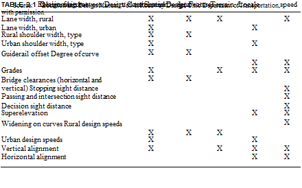
Table 2.1 (Ref. 7) shows the relationship of the functional classification, traffic data, terrain, locale, and design speed to the various geometric design features listed on the chart.
It should be noted that there are situations when it will not be possible or reasonable to meet the design standard for a particular feature in a given project. When this occurs, the designer must bring this to the attention of the reviewing authority for approval of what is being proposed, or suggestions on what other course of action to take. A design exception must be approved by the reviewing authority when a substandard feature is allowed to remain as part of the design. In this way, it can be documented that this was not an error or oversight on the part of the designer and that every effort has been made to provide the best design possible in the given situation.


Leave a reply