Category Water Engineering in Ancient Civilizations. 5,000 Years of History

Windmills

The origin of the windmill is controversial. In a manuscript on Pneumatics, Heron of Alexandria includes the description of a wheel driven by the wind and driving the pis­ton of an organ. But the authenticity of this passage has not been resolved – it could have been added during the Islamic period. In any case, even if this passage is authentic, the link between this invention and the appearance of the true windmill in central Asia seems to be very weak.

The backdrop of Heron’s apparent reference to a windmill is the ubiquitous presence of water mills on all of the rivers. On the Tigris at Baghdad, on the Seguro at Murcia, on the Ebre at Saragossa, there are even boat-mounted water mills. Mills are the indis­pensable tools of an agricultural economy. But on the Persian plateau there are few, if any, watercourses. This undoubtedly led to the invention of the windmill at an indeter­minate date but perhaps prior to the Arab conquest. In about 660 a Persian had affirmed to the caliph Omar that a windmill could be built. The windmills of Seistan (to the east of Khorassan) were known to Arab geographers from the 9th century on, in particular to the Banu Musa brothers.[363] These mills turn on a vertical axis; their vanes are inside a chamber at the top of a sort of tower, open to the four cardinal directions with shutters that one can close depending on the direction or the force of the wind. The rotation of the axle directly turns a millwheel that is in the chamber just below. These mills are described somewhat later by Chinese authors who give a precise account of them:

“In the western countries called Herat and Samarcand, there are many windmills. Brick walls are built to form a sort of house having openings at its summit, facing the four directions, out­side of which screens can be placed to direct the wind. In the chamber below is placed a wood­en axle, with sails (literally planks to ride the wind) fixed to it. Whatever the direction of the wind, the axle always turns, and the stronger the wind, the more work can be accom­plished.”[364]

The norias

The hydraulic noria, sometimes called the current noria, first appeared in the period of the Roman Empire. Herein we simply call this the noria. The very first evidence is found in the description of Vitruvius (around 25 BC) as we have cited in Chapter 6. Vitruvius describes the machine very clearly, but says nothing about the location of the particular device. Moreover we are not aware of any other mention of the noria by Roman writers. The second piece of evidence is found in the very heart of the land that will become the location of the largest norias: it is in a mosaic discovered at Apamea, a Hellenistic and Roman city located some fifty kilometers to the north of Hama oppo­site the depression of Gharb where the Orontes flows. We know from a signature that this mosaic dates from 469 AD. It is unusual to find machines represented in mosaics, suggesting that during this period the noria was considered to be an important element of the patrimony of the region. The tradition persists to this day, since even now the city of Hama maintains and renovates its norias. The accounts of Arab travelers in the 12th and 13th centuries, cited earlier in this chapter, speak of beautiful norias in the same breath as the Orontes and the city of Hama. Ibn Battuta, in the course of his grand voy­age, observes norias at Amasya in Anatolia, on the Karan and the Fars, at Samarcand and even at the mouth of the Ganges. He mentions that they also can be found in China (but surely did not see them himself). As we have described earlier, norias are also

The norias

Figure 7.18 Detail of the wheel of the al-Damalik noria at Hama (note in particular the paddles and runnels). In the background is the wheel of the al-Hudura noria. (photo by the author).

The norias

Figure 7.19 In the foreground, the axle of the noria al-Gisriyya at Hama; and in the background the noria of al-Mamuriyya, dating from 1453. Prior to its first reconstruction, this latter noria was the second largest in size (after the noria of al-Mohammadiyya). (Photo by the author).

found in Andalusia (Toledo, Cordova) and at Fez. Still, in the eyes of these travelers, none of those norias are as remarkable as those found at Hama.

Norias are machines that can lift water to a great height, but they are also very expensive. They are thus best suited for implementation on rivers of fairly regular dis­charge, flowing in a well-defined course, and having rather steep banks – and at sites where gravity irrigation would be otherwise difficult. The norias of the Orontes have been particularly well studied.[362] The typical machine comprises a narrow wheel whose diameter depends on the desired lift. As is the case for its ancestor the lifting wheel, the noria has wooden water boxes or jars, on its perimeter to lift the water. The paddles are mounted on the outside circumference of the wheel; on the Orontes, these paddles are spaced at approximately 50 cm, whatever the diameter of the wheel. Rotation of the wheel is induced by the river current, channeled through a canal scarcely wider than the wheel itself and impinging on these paddles. On modest rivers such as the Orontes or the Khabur, an overflow dam raises the water level at the entrance to this canal, thus aug­menting the speed of the current that drives the paddles.

The water boxes have an opening in the side (Figure 7.18). The boxes fill with water when they are immersed in the canal; then, when at the top of the rotation of the wheel, they pour their water out into a trough parallel to the wheel, at the top of the structure

The norias

Figure 7.20 Spoke structure of the noria al-Gisriyya at Hama (photo by the author).

called the “tower”. The trough becomes an aqueduct that delivers the water to the dis­tribution system. The tower and aqueduct are easily visible on Figure 7.7, as well as on the remains of the norias of Khabur (Figures 7.12 and 7.13). One end of the wooden axle of the noria rotates in a notch that is part of the tower; the other end rotates on a support that is, on the Orontes, a triangular masonry structure (this “triangle” is clearly recognizable in the mosaic at Apamea, see also Figure 7.19).

A single dam can accommodate several norias (Figure 7.8) and a single noria can moreover be fed by several supply canals (Figure 7.13), each dedicated to one wheel. If these wheels are of different diameter then each has its own outlet trough; if not, they can pour their water into the same trough. Often one can take advantage of the dam to install a mill as well (Figure 7.12).

One finds the largest known norias at Hama – those called al-Mohammadiyya and al-Mamuriyya, dating from 1361 and 1453. Their wheels are approximately 21 m in diameter. On rivers subject to destructive floods, for example the Euphrates, there is no need to bring excessive care and quality to the construction of the wheels as they are most often destroyed by the annual flood and thus must be rebuilt each year. On the other hand on the Orontes, a river of quite regular flows, the wheels are built with great care. Large and narrow, they are trued to an astonishing precision (several centimeters on wheels from 10 to 20 m in diameter). They are serviced each year at the end of the irrigation season. Their wooden arms are not radial, but are laid out in an arrangement that is common to all the wheels, but particularly those of the Orontes, an arrangement that is clearly visible on Figure 7.20.

Arab Science and Hydraulic Machinery Hydrodynamics and Marvelous Machines

We have seen that a political climate favorable to intellectual activity evolved under the Abbassides – and this climate coincided with important needs for hydraulic develop­ment. Scientists and often engineers made use of all the fruits of Greek and Hellenistic science in parallel with major construction projects. They produce precise mechanisms, water clocks (clepsydres) and other marvelous machines following the tradition of the ancient scholars of Alexandria, Philon, Ctesibios, and Heron.

Three brothers – Muhammad, Ahmad, and al-Hasan Banu Musa, known to the caliph al-Mamun around 820, wrote numerous treatises on these mechanisms. Of par­ticular note is the Kital al-Hiyal, Book of Ingenious Mechanisms, written in Baghdad about 850. This book contains descriptions of many devices that reveal a perfect mas­tery of hydrostatics.

The fact is that Archimedes, as well as other authors such as Aristotle, Euclid, and Heron, had been translated into Arabic by that time. Al-Khazini, a scientist of the 12th century, put together a synthesis of the hydrostatics of Archimedes and the premises of dynamics of Aristotle and his commentators. In his book, called Kitab mizan al-hikma (book of the balance of wisdom), he differentiates between the two types of action that can be exerted on mobile bodies in water – hydrostatic forces, and hydrodynamic forces arising from the movement of the body. These latter forces “differ because the shapes of the bodies differ”. He also extends the theories of Archimedes to hollow bodies, as well as to hollow bodies carrying a load. Here the theory of ship buoyancy makes its appearance.

A characteristically Aristotlean trait appears in the vision of groundwater developed in the 11th century by the mathematician al-Karagi, a vision that we cited earlier in the context of his treatise on qanats:

“God – may he be blessed and exalted – created a compact universe without empty space, and attributed to each element – the celestial sphere, stars, fire, air, water, and earth – its own place, a place to which it tries to return if separated from it. Dense bodies like earth and water (…) seek the center of the universe, and the most dense arrive there first; from which it follows that the earth is at the center of the water that surrounds it.”[358]

And from this comes the explanation of groundwater movement:

“It is in the nature of water to seek, by its movement, the center of the earth, and not to rise.”

Springs are then explained by the slope of the impermeable layers over which groundwater flows:

“When the groundwater has its bed upon a hard surface, and this hardness, lying next to a fis­sure where the water flows, extends to the summit of a mountain, the water emerges and can be tapped at this summit, if it is nearer the center of the earth than the place from which the fissure is supplied.”[359]

Other authors also reveal a great deal of refinement in Arab research into these mechanisms. One is al-Muradi, who in the 11th century describes automatic controls that are powered by waterwheels. Another is al-Jazari who, at the very beginning of the 13th century, brought the art of the clepsydre (water clock) to its pinnacle.

We have been emphasizing the influence of the Greek and Hellenistic scientists on Arab thought. But we must not ignore the Chinese influence insofar as technology is concerned. After the battle of Talas, Chinese prisoners introduced the Chinese technol­ogy of the hydraulic pestle to the nascent paper industry at Samarcand; we will come back to this in Chapter 8.[360] This technology subsequently spreads to all the Arab world, then into the Occident. A century later, in 850, the historian al-Jahiz assembles an inven­tory of “products” imported from China to Iraq. In this inventory he naturally mentions silk, but also includes a curious list that contains, in order, “female slaves” and “hydraulic engineers.”[361]

. The south of Morocco and the Saharan oases

In 1031 the caliphate of Cordova breaks down, fragmenting into small kingdoms. Alphonse VI of Castilla seizes the opportunity to take Madrid in 1083, then Toledo in 1085. The Andalusians call for help from the only powerful Occidental Arab dynasty of the time, the Almoravides of Morocco. Their chief Youssef ben Tachfin puts an end to the advance of Alphonse VI when he passes through Spain, and he brings Morocco and Andalusia under his unified command. His son Ali, raised in an Andalusian culture, suc­ceeds him in 1106. Andalusian scholars and literati follow him to Marrakesh, capital of the Almoravides. This contact probably explains the appearance of the qanat technolo­gy in Morocco.

The Almoravides, Berbers from the south, had occupied Sijilmassa, the great cara­
van center of Tafilalet, in 1055, and then conquered all of Morocco and founded Marrakesh in 1060. The construction of the first qanat of Marrakesh is documented thanks to al-Idrissi. Ali decided to build it in 1107, and the project was completed by a certain Obeyd Allah ibn Younous (that is, son of Jonas) al-Muhandes (which means the engineer).

“At the time there was only one garden [….]. Obeyd Allah went to the highest point of land overlooking this garden. There, he had a very large rectangular pit dug, from which he had dug a single outlet that gradually descended (.) to the garden for which it supplied water in a continuous fashion. With the naked eye, one cannot detect, on the ground, any slope that would enable the water to flow from the bottom of the pit to the surface of the garden. To understand this, one must understand the clever trick that was used to supply the water. This trick consisted in evaluating the difference in ground level (from the bottom of the pit to the garden). The Emir of the Muslims, who very much appreciated the work of the engineer Obeyd Allah, paid him with silver and clothing. [….] After that, inspired by the example pro­vided by this man of art, the inhabitants of Marrakesh set about capturing water and bringing it to their gardens, to the point that many of them could only increase in size, buildings grow­ing up around them, embellishing the skyline of Marrakesh.” [348]

According to the text, this Obveyd Allah ibn Younous well understood the technique of the qanats when he came to install them in Marrakesh. If one juxtaposes the dates (the event was 80 years after the taking of Madrid, one year after the birth of Ali, who was raised in contact with the Andalusian literati) and the facts (according to al-Idrissi, it was Andalusian engineers that Ali called upon to build the first bridge on the wadi Tensift), it seems reasonable to presume (as did Henri Goblot) that this engineer came from Spain.

Over a thirty year period some fifty qanats are built on the plain of Marrakesh (the Haouz), where they are called khettaras, bringing 5,000 hectares under irrigation. The Almohades took over from the Almoravides after 1160. They built new qanats and con­structed an extended network of canals supplied by the rivers to increase this irrigated land area to 15,000 hectares. After some retrenchment in the 16th century, the irrigated area grows to about 20,000 hectares in modern times. There are some 600 identified qanats, 500 of which were still in service in the middle of the 20th century. These qanats are generally quite shallow, for the water table issuing from the Upper Atlas mountains is only about 20 meters below the ground surface. The qanats are limited by the land slope to only from 500 m to several kilometers long, and the wells are closer together than those of Iran. The average discharge of a qanat at Marrakesh is of the order of 40 m3/hour.[349]

Sugar cane is grown on the plain of Sous and in the haouz of Marrakesh. This crop requires considerable water. Sugar processing is also water-hungry, both in its need for hydraulic energy (mills to grind the cane) and for preparation of sugar bread. This water is most often taken from the rivers, but it can also come from the qanats – both those of

Marrakesh as well as others on the plain of Sous, particularly in the region of Aoulouz and the surroundings of Agadir. The sugar industry quickly grows to play a significant role in the economy of Morocco, a role it maintains up until the 17th century. Important hydraulic infrastructure is developed to support this industry, particularly by the Merinides at the end of the 14th century and then by the Saadians in the 16th century, on the plain of Sous and at Chichaoua in the Haouz.

Fez was established toward the end of the 8th century on a site that was at the cen­ter of an agricultural plain and naturally well supplied with water, the terminus of the route that crosses the Atlas near Sijilmassa. In the 11th century the Almoravides build canals to irrigate the gardens of Fez, and also build water mills. Al-Idrissi observed in the 12th century that in the district with the best water supply, al-Qarawiyyin, the deliv­ery and drainage networks were particularly well developed:

“Al-Qarawiyyin has an abundance of water that circulates through all the streets and allyways, in conduits that the inhabitants can open when they wish to wash the neighborhoods during the

night and have them perfectly clean in the morning. In each house, be it large or small, there

53

is a pipe for both clear or dirty water.”

Norias appear in Fez in the 14th century, and numerous water-based activities devel­op in the city. In the 16th century Leon the African enumerates over a hundred public baths and nearly 400 water mills supporting all sorts of industrial uses.[350] [351] [352]

Sijilmassa is, with Marrakesh and Fez, another grand center of activity in medieval Morocco up to the 14th century:

“Sijilmassa is an important capital, located some distance from a watercourse that disappears to the south of the city. [….] This city is rich in dates, fresh and dry grapes, fruits, cereals, pomegranates and diverse other agricultural products; the city pleases foreigners who come from all directions in large number. [….] The canton possesses mines of gold and silver. [….] Sijilmassa is surrounded by the sands of the desert, its inhabitants use water holes.”[353]

This ancient city was founded in the middle of the 8th century. Recently discovered vestiges have been the focus of American-Moroccan research efforts between 1988 and 1996. The city is located in the Tafilalet, one or two kilometers to the west of the pres­ent Rissani (which is some 200 km east of Ouarzazate) near the wadis Ziz and Rheris that descend from the High Atlas. Sijilmassa is a node of communication with the Orient (via Ouargla) and especially with Sudan, a source of gold. Ancient texts present an image of grand agricultural prosperity, the remains being seen in present-day palm groves:

“She (Sijilmassa) has a series of castles, houses and buildings along an abundant water course that comes from the east, i. e. from the desert, and whose flow increases in the summer (with the snowmelt of the High Atlas), much like the Nile. Its waters provide for irrigation of crops,

which along with the use of Egyptian peasants leads, as everyone knows, to very good har­vests. In certain years, following floods of this river, water is so abundant that the grains har­vested in the previous year grow again without any need to replant the fields.”[354]

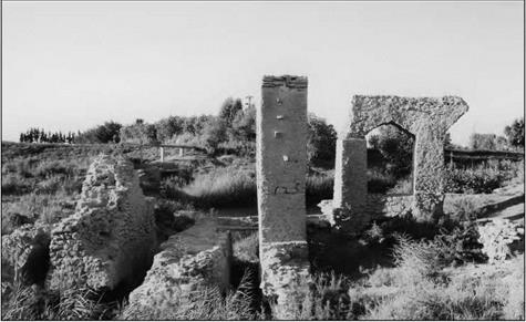
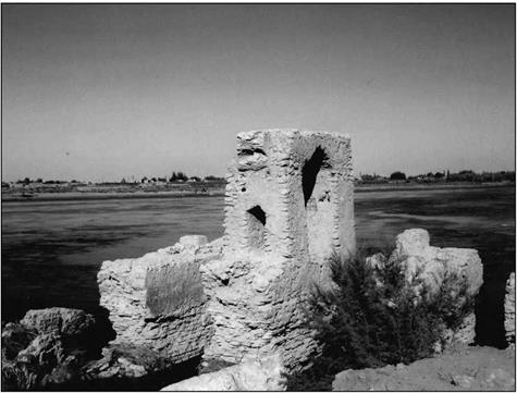
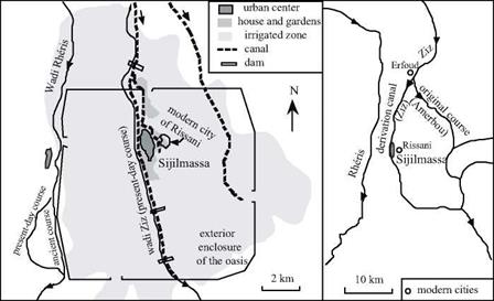
This text suggests a practice of flood-recession agriculture, certainly as in Egypt, but also in conditions that would appear to be close to those that we have described in Chapter 3 for the east of Arabia Felix (Yemen). Similarities in architecture between the ancient cities of Yemen and the ksar (fortified villages) of Tafilalet suggest another pos­sibility -that the hydro-agricultural techniques used at Sijilmassa have their origin in a Yemeni migration. Field studies [355] indeed show that small dams were constructed on the wadi Rheris, to be destroyed several times by floods but then rebuilt in other loca­tions. But it is especially the wadi Ziz that is developed and managed. Initially, the Ziz ran much more to the east, along a course that is today called the wadi Amerbou. At some undetermined time, the course of the Ziz was changed by a dam situated some 15 km to the north of Sijilmassa (opposite the present-day Erfoud, where traces of a stone structure still exist). The wadi was diverted into a canal that runs along the western side of the city of Sijilmassa (Figure 7.17). This canal is in its own right the source of sec-

. The south of Morocco and the Saharan oases

Figure 7.17 The principal hydraulic developments of Sijilmassa (after Messier, 1997).

ondary derivations for irrigation of the oasis and subsequent return flow to the original course further to the south. This original course (the Amerbou of today) handles the drainage of excess flood waters. Over the centuries this canal becomes the source of the modern watercourse of Ziz.

To complete this broad-brush painting of the water resources of Tafilalet, we should note that along with Marrakesh, this region constitutes the second flowering of qanats of Morocco. Remains of 300 qanats are identifiable today, half of them still in service. Their dates of construction are unknown.

Another very important blossoming of qanats is located in the oases of Gourara, Touat and Tidikelt in present-day Algerian Sahara, south of the western Grand Erg. This is a chain of palm groves clustered around the foot of the Tadema’tt plateau (Figure 7.16).

These oases were undoubtedly populated by migrations of Jewish Berbers from Cyrenaic, the Zenata, fleeing Roman colonialism of the 2nd century AD. But in gener­al we assume that the history of the Saharan qanats reaches back only to the 9th or 10th centuries AD, and that their history is unconnected to that of the old Roman qanats of Libya and Tunisia (Chapter 6), at this time a forgotten technique.[356] The introduction of qanats grew out of new immigration waves from the Orient – we must remember that at this period, the Sahara was not nearly as water-starved as it is today. But without these thousands of qanats the grand oases would not have survived to the present. At the beginning of the 20th century some 400 active ones were known in Gourara (especially on either side of Timimoun); 440 in the Touat chain of oases between Adrar and Tauourirt, where they are the sole source of water; and 125 in the Tidikelt, especially around Aoulef and In Salah. They are from 2 to 15 km long, with very closely spaced wells.[357]

The Arab Occident Water in al-Andalus

The Arabs came not only from North Africa, but also from Arabia, Syria, Iraq, Yemen, and Egypt. In 711 they conquered Spain, a country that had been occupied by the Visigoths since the fall of the Roman Empire. They brought with them all the Oriental technologies for water management: the ancient shaduf the bucket chain or saqqya, the noria, and qanats. The Arabs preferred developments of more modest scale in the Mesopotamian tradition compared to the grand Roman hydraulic works. The great Roman dam-reservoirs like those of Proserpina and Cornalvo were apparently not brought back into service.

42

It is thought that the oldest Arab project is an overflow dam built at Cordova, the capital of the Umeyyade caliphate. Its total length of425 m exceeds the width of the river Guadalquivir, since it comprises multiple independent segments to increase the effective length of the weir and thus to limit the rise in water level during floods. We have seen this technique earlier in Assyria. The dam is equipped on one side with a large noria which lifts water for the l’Alcazar of Cordova. And at the three angles downstream of its broken line it has water mills, each equipped with four wheels. Many other mills existed along the course of the Guadalquivir, from Cordova down to below Sevilla:

“He who wishes to travel by water from Sevilla to Cordova can embark on the river and trav­el upstream, passing by the mills of al-Zrada, by the Mannzil Aban bend, [….] the Nasih mills, to arrive in Cordova. [….] At Cordova one sees a bridge that surpasses all others in reputa­tion and solidity. [….] Downstream of the bridge, and across the entire width of the river, there is a dike that is built of stones called “coptes”. The columns are of unpolished marble. On this dike one can see three buildings, each containing four mills.”[341]

But it is agriculture, and its need for irrigation, that is the driving force for the main hydraulic projects. The Arabs establish the cultivation of cotton, sugar cane, and rice in Spain. Agronomy manuals and plants themselves circulate between al-Andalus and the Arab Orient. The Andalusian school of agronomy flourishes, as seen in the treatises of Ibn Wafid and Ibn Bassal at Toledo; Al-Khayr, Ibn Hadjdjadj and Ibn al-Awwan at Sevilla; Ibn Beithar at Malaga.[342] This agricultural development supports significant population growth in al-Andalus between the 9th and 12th centuries.

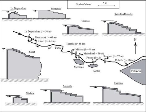
The most celebrated of the irrigation projects is on the river Turia, to the north of Valencia (Figure 7.15).[343] It is possibly the descendant of an ancient irrigation network of the Roman period. Between 911 and 976 the Arabs built masonry outflow weirs cov­ered with large stones sometimes interlocked with iron pins, as we have seen on numer­ous Arab or Persian dams. Among the nine sills of this system, from 1.4 to 7 m in height, five very likely date from the Arab period – they are mentioned in an edict of the king Jaime II in 1321 after the Reconquest of Valencia. Almost all of these sills have a down­stream face in the form of stairsteps to serve as an overflow energy dissipater. Each sill feeds an irrigation canal, alternately on the right and left banks of the Turia river, and all of these canals subsequently branch out downstream.

From 961 any conflicts arising from water distribution, spillage, and the mainte­nance of the sills and canals are handled by the water tribunal of Valencia. This tribu­nal, whose deliberations are strictly oral, meets each Thursday in the mosque. After the Reconquest, during which the entire irrigation system is conserved and maintained, this same tribunal meets in the square of the cathedral of Valencia. This tradition continues unchanged to the present day.

Many other projects were developed on virtually all the rivers of the south and east of Spain. Upstream of Murcia there is a rather large dam 7.5 m high and 305 m long on the Segura river[344], built in the reign of al-Hakem (961-976) in a region that had been scarcely cultivated beforehand. It feeds two irrigation canals, one on each bank, with provisions for removal of sediment from the reservoir. These canals branch out exten­sively, supplying an irrigated domain of 5,000 hectares (and this area triples over the course of the centuries). They extend to downstream of the city of Murcia where anoth­er irrigation system, that of Orihuela, takes over. This system makes use of multiple-sec­tion sills, as at Valencia, as well as norias. Of course there are also mills, and even boat – mounted mills on the Seguro River near Murcia:

“There are (at Murcia) mills constructed on boats, like the mills of Saragossa, and which, being on the boats, can be transported from one place to another. There one can see gardens, orchards and crops of incalculable number.”[345]

All of these irrigation networks are still in service today, having been repaired and maintained over the centuries.

Mills – both water-driven (horizontal wheels up until the 12th century, then occa-

The Arab Occident Water in al-Andalus

Figure 7.15 The sills of the Turia river, permitting irrigation of the huerta of Valencia from the 10th century. The sections across the structures are shown to the same scale; their lengths are indicated in parentheses. The azudes of Moncada, Mestalla, Favara, Rascana and Ruzafa are surely the oldest; the sills of Cuart and Mislata could be from after the Reconquest of the 13th century. From Fernandez Ordonez (1984).

sional vertical wheels) and wind-driven (such as at Malaga) – were ubiquitous in Muslim Spain. It is said that there were 5,000 mills in the region of Cordova, and 130 within the walls of Grenada alone. The mills belong to private individuals or groups of individu­als, as in the Orient. It is only after the Reconquest that they become privileged feudal and ecclesiastical property, as in the Christian Occident. There was no lack of conflicts for the use of water, given the needs of the flour trade and irrigation[346].

One can find qanats on the grand plateau of Castilla, the most important being those of Madrid. From the very founding of the city by Mohamed Ist (825-886), networks of qanats are put in place to provide water for the city. They are from 7 to 10 km long, with drops of from 80 to 100 m. Indeed, it is perhaps due to the abundance and the quality of water furnished by the qanats that Madrid was chosen as capital of Spain by Philippe II, in 1561.[347] According to the geographer al-Idrissi, a large noria lifts water from the Tagus River up to the city of Toledo.

Hydraulics and prosperity in the heart of the Arab world

Arab agriculture included exotic crops such as cotton, rice, and sugar cane in addition to traditional grains and fruits. Cotton was known in Mesopotamia since the time of the Assyrians, but was essentially undeveloped. These crops require considerable water, and therefore are grown in the large irrigable zones on the shores of the Khabur, the Euphrates, and the Tigris.[325] The Muslim world uses all known existing techniques to develop irrigation. This includes derivation canals from rivers and wadis, water-lifting machines, and even drip irrigation for young plants, a technique known since the 5th century and wonderfully described in an Arab work of the 12th century.[326] The shaduf is used to lift water out of rivers and canals, but on a small scale. The bucket chain or saqqiya and the noria, are the most widely used devices. The noria sees considerable application, especially on rivers of regular flow such as the Orontes and the Khabur, and also on the middle Euphrates. We will come back to this point further on.

Qanats exist also, but it is usually impossible to tell if the origin of a particular installation is Arab, Roman, or even earlier. In Syria (where they are called foggaras), there are 45 qanats in the Palmyra region, 50 in the ghouta of Damascus, 35 between Damascus and Homs, 20 to the southeast of Homs, 50 to the east of Hama, 15 to the southwest of Aleppo, and 25 to the east of Aleppo.[327] [328] In the 12th century, Ibn Jubayr takes note of them between Homs and Damascus:

“We camped in a large village of Christians called al-Qara where no Muslim lived, and that has a caravanserai much like that of a large fortress. In the center, one can see a large basin

that is always full of water, supplied by an underground stream coming from a distant „30

source.

This axis Aleppo – Hama – Homs – Damascus, in Syria, is particularly developed and irrigated. We mentioned above the qanats, frequently encountered along this corri­dor, as well as the water taken from the Barada for the ghouta of Damascus (Figure 7.6).

Homs is irrigated using canals issuing from the Roman dam of Homs lake (Figure 6.33).

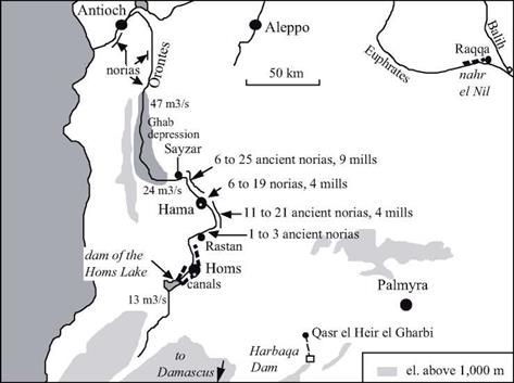
The steep banks of the Orontes at and around the city of Hama are irrigated thanks to large, numerous, and particularly famous norias (Figure 7.9). The oldest of these norias to which a date can be assigned (for its canal carries an inscription) was constructed in 1361 (Figure 7.7). But one cannot separate the norias from the city of Hama; in 1185, Ibn Jubayr tells us they were already there:

“On the two banks (of the Orontes), starting from the hydraulic wheels and extending regular­ly out, are gardens, whose tree branches hang over the water. […] On one of the banks that borders the outlying district one finds washing stations arranged like several rooms; the water, raised by a hydraulic wheel, crosses into all the hidden crannies.”[329]

Hydraulics and prosperity in the heart of the Arab worldFigure 7.7 The noria al-Muhammadiya and its aqueduct at Hama, dated as 1361 from the inscription on a pillar of the aqueduct. As are the other norias of Hama, this one has been maintained and regularly renovated since its initial construction. With a diameter of 21 m, it is the largest known ancient noria (photo by the author).

Подпись: m.k»*’

Figure 7.8 The group called the “four norias” at the entrance of the Orontes into Hama. The aqueduct of the two norias at the right has disappeared (photo by the author).

The remains of some fifteen of these norias (or the gardens that they irrigated) can be found in the archives of the 16th century of the tribunal of Hama.[330]

Qanats and norias are costly devices that provide copious quantities of water. Therefore social organization is needed to regulate their use. In the Muslim world, peri­odic hourly time schedules are established at a scale of about ten days. In the Syrian areas irrigated by qanats to the north of Damascus, irrigation periods are every twelve days, or rather every 24 half-days (from two hours before dawn to two hours after sun­set). The unit of time is one “hour” of a hundred minutes, and through an alternating schedule a user can draw water first for a daytime period, then a nighttime period.[331] At Hama, on the other hand, weekly cycles are used to allocate water from the norias among the fields, the mosque fountains, or the public baths.

In some cases, Roman hydraulic works are brought back into service. For example, when the tenth Umeyyade caliph Hisham (724 – 743) decides to build a palace in the

Hydraulics and prosperity in the heart of the Arab world

Figure 7.9 The valley of the Orontes, showing the locations of the ancient norias. The lower figure shown corresponds to the number of norias that can be reliably dated from the 16th century (from inscriptions and archive documents analyzed by Zaqzouq, 1990). The implantation of norias is particularly dense between Rastan and Sayzar, where the slope of the Orontes is a fairly regular 1.1 m/km. The indicated discharges are the mean flow of the Orontes at different points (after Delpech, girard, Robine, Roumi, 1997).

Hydraulics and prosperity in the heart of the Arab world

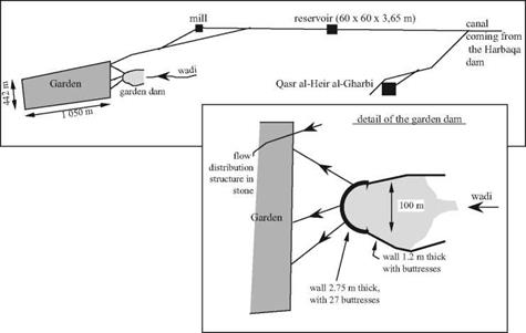
Figure 7.10 Layout of Umeyyade hydraulic installations at Qasr al-Heir al-Gharbi, and of the garden dam (after Sailby, 1990; Calvet and Geyer, 1992).

desert of Palmyra in 727 (at the intersection of the caravan routes, on the road between the capital Damascus and the middle Euphrates), he makes use of the ancient Roman dam of Harbaqa (Figures 6.34, 7.9).[332] This palace, known as Qasr el-Heir el-Gharbi, is supplied by an underground canal issuing from this dam that is 16.5 km long. The aqueduct supplies a reservoir that is 60 m on a side and 3.65 m deep. The aqueduct also supplies a mill, and further downstream, a nearly rectangular large cultivated area of 45 hectares, or garden. A rather strange dam (the garden dam) is built to capture water from the wadis that discharge downstream of the Harbaqa dam and to create a supplementary reservoir near the garden. Since the valley of the wadi is ill defined at this location, the ends of the dam extend in an unusual fashion along the edges of the valley (Figure 7.10).

The open canals downstream of the reservoir are earthen, but the hydraulic works and diversion gates are of stone, following the traditional practices of the region.

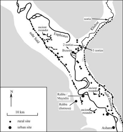
Mesopotamia becomes the granary of the great Arab cities. The entire irrigation sys­tem inherited from the ancient civilizations is carefully conserved, further developed, or put back into service if previously abandoned. The 35-km long grand canal called nahr Sai’d (Figure 7.11) is built on the middle Euphrates, apparently starting from the intake of the very ancient bronze-age canal Isim Yahdun Lim (Chapter 2). It brings water to the city of Rahba, founded in 820 on the riverbank by the Abbasids and subsequently relo­cated to the edge of the escarpment after an earthquake in 1157. This canal, along which there are several offtakes, is excavated into the plain. Therefore it cannot support gravity irrigation of large areas, as was done in the same region by the bronze-age canals.

This canal is instead used as a permanent source of water to be lifted into the gar­dens using saqqyas, remains of jars have been found there.[333] This practice explains why the region’s villages, all Islamic, are located directly on the canal and its offtakes. The nahr Sai’d is destined to be abandoned in the 13th or 14th century during the desertifica-

Hydraulics and prosperity in the heart of the Arab world

Figure 7.11 The confluence of the Khabur and the Euphrates – an area that is very developed from the 8th to the 12th centuries with the nahr Said for irrigation on the right bank and the grand navigation canal on the left bank (nahr Daourin) likely dating from the Bronze Age (Figure 2.7).

The most downstream zone (where the ancient Mari was located) is almost desert in this period. Ashara is built on the site of the ancient Terqa. After Geyer (1990), Berthier and d’Ont (1994).

tion of the region after the Mongol invasion (Rahba is abandoned about 1400).

The Raqqa region is further upstream on the Euphrates at the confluence of the Balih, and irrigated on the right bank from the Umeyyade period. The city of Raqqa itself, on the left bank, is an ancient Hellenistic implantation that was refounded by the Abbasid al-Mansour in 772. The caliph Haroun al-Rachid (the caliph of A Thousand and One Nights) especially develops the city during his residence there from 797 to 808. The

Hydraulics and prosperity in the heart of the Arab world

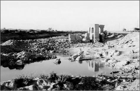
Figure 7.12 Vestiges of a noria and its mill at al-Lawriye on the lower Khabur. The photo is taken from the left bank, downstream; to the left, one can see the remains of the dam (photo by the author).

city benefits from an extended irrigation network whose spine is a grand canal from the Euphrates, 10 m wide and more than 16 km long, called the nahr el-Nil.[334]

Navigation on the Euphrates is important from the Umeyyade and Abassid period up until the 11th or 12th centuries.[335] Rahba (Mayadin) controls an important fluvial port. The existence of Abbassid sites all along the ancient nahr Daourin (Figure 2.12) shows that this navigation canal is to all appearances brought back into service at this period.

On the Tigris, the nahr Awan canal services the new city of Baghdad, whose popu­lation in the 13th century is nearly a million and a half inhabitants. This grand canal, parallel to the Tigris, was built by the Sassinids, then enlarged and extended to capture water from the Diyala. In the 9th century a dam is built on the Adheim (or Uzaym) river, 150 km to the north of Baghdad. This dam, 15 m high and nearly 200 m long, feeds two new irrigation canals, the nahr Batt and the nahr Rathan. Like the other dams built by

Hydraulics and prosperity in the heart of the Arab world

Figure 7.13 Remains of a noria at Rweshed on the Khabur, immediately upstream of its confluence with the Euphrates. This noria had three identical wheels. At the left one can see the three canals and at the right, the remains of the aqueduct (photo by the author).

the Arabs (those of Fars, for example), this structure is built of stones interlocked with lead seals.

During the 7th and 8th centuries the simple military camp of Basra becomes a true city with a new irrigation system fed by the Chatt al-Arab waterway, the common course of the Euphrates and the Tigris. According to al-Baladhori, a certain Hassan the Nabatian directs the drainage and irrigation works in this region. The “Hassan reservoir” at Basra is attributed to him. The first tidal mill is built at Basra in the 10th century to operate during the falling tide.[336] But despite these hydraulic works, the swamps of lower Mesopotamia cause Basra to be known for its unhealthy air and the “yellow tint of its inhabitants”, as described by Ibn Juzavy, the editor of the memoirs of Ibn Batthta.

In Arabia itself, particularly in the regions of Mecca and Medina where pilgrims congregate, numerous small dams are built on the wadis to provide water reserves through diversion of flood waters into basins and cisterns. There are some fourteen of these near Mecca and four in the region of Medina. The dams are from 2 to 11m high and 25 to 225 m long. The largest is the Qusaybah dam near Median, notable for its height of 30 m.[337] Certain dams in this region have inscriptions that would date them from the Umeyyade era. But some well-known travellers suggest otherwise. They attribute the water-resource development, needed for the caravans of pilgrims who cross the desert between the holy cities of Mesopotamia, to the queen Zubayda, cousin and wife of the caliph Haroun al-Rachid. Some descriptions of these watering places men­tion elaborate structures, not only the dams cited above but also the qanats when a per­manent water source is found:

“Friday morning, we camped in a place called Birkat al-Marjum, where there is a basin for which they built, on the hill overlooking it, a pipeline bringing water from far away. The instal­lation is perfect and shows how impressive human resources are and the great things that can be done with them. [….]. All of these basins, all the reservoir, wells, and rest stops between Baghdad and Mecca were developed by Zubayda, daughter of Ja’far ben Abi Ja’far al-Mansur, wife and first cousin of Harun alRashid. She devoted all of her life to this project.”[338]

The Arab cities, like the Roman cities, are major consumers of water – for baths, mosque hydrants, and caravanserais. According to Ibn Jubayr, Damascus has “nearly a hundred baths and nearly four hundred washing sites with running water everywhere” in the 12th century. Whether it be from their Roman heritage or from their Arab roots (like Rahba), these cities also have sewers.

Hydraulics and prosperity in the heart of the Arab world

Figure 7.14 Remains of an ancient noria on the right bank of the Euphrates, downstream of the Doura Europos escarpment, about 40 km downstream of Rahba (photo by the author).

The Decline

Catastrophes strike the Arab Orient from the 11th century on, and especially in the 13th century. Its population declines and farmland reverts back to desert or, even worse, changes into swamps like those of the lower Mesopotamian lands. In Syria the crusades cause an exodus from rural settlement beginning in the 11th century; however this exo­dus is partly reversed by 12th-century agrarian reforms that encouraged a return to rural agriculture. But then the great tragedy of the Mongol invasions occurs. We have already seen how Ghengis Khan had ravaged Samarcand, Bukhara, Marw and the cities of Khorassan. And now in 1258 his grandson Hulagti razes Baghdad (later rebuilt) and irre­versibly damages the Mesopotamian irrigation system. The Ottoman era begins in the 16th century; Constantinople becomes Istanbul and is endowed with new water supply systems such as the Maglova aqueduct, constructed in 1564.[339] [340]

The great libraries of the Abbasids

Two grand libraries flourished under the Abbasids. They were motivated by the same goals as the ancient libraries of Alexandria and Pergamon: the prestige of the sovereign and the attraction to scholars from everywhere. The grand library of Baghdad, the Bayt al-hikma was developed under the reign of Haroun al-Rashid (786 – 809). It benefited from the latter’s acquisition of ancient Greek works from the court of Constantinople, a practice continued by his successor al-Mamun (813 – 833). A strong memory of the belle epoch of these rich libraries persisted in the 15th century:

“The caliphs and the sovereigns had a lively interest in the grand libraries and paid close atten­tion to them, enabling them to acquire beautiful and numerous collections. It is said that the greatest libraries of Islam were the following three: the library of the Abbasid caliphs of Baghdad, […], the library of the Fatamide caliphs of Cairo […] and the library of the Umeyyade caliphs of Spain.”[324]

The influence of the Baghdad library begins to fade when the capital is relocated to Samarra in 836. But Alexandria, Antioch, Edhessa, Haran, and Nisibia remain great intellectual centers.

In the heart of the Arab world: the splendor of the Umeyyades and the Abbassids

Byzantium, the Sassanides and the new Arab empire

Water supply systems of the Byzantine cities do not measure up to those of the Romans, either in quality or in quantity. In many Byzantine cities, such as Apamea-on-Orontes or even Constantinople itself, aqueducts are abandoned in favor of cisterns, sometimes very large and fed by runoff from rainstorms. Small rural communities located along wadis or on small rivers implement numerous hydraulic developments at their scale[317]
such as modest derivation canals that support gravity irrigation of valley fields, with many small mills.

The Byzantines indulge in large-scale hydraulic activity in Anatolia, where they build several dams. One among them is the Dara dam, constructed under Justinian (527­565) on a tributary of the Khabur. It probably has an arch in its central portion – at least this is what Procopius of Caesarea, in the 6th century, attributes to the dam’s architect, Chryses of Alexandria:

Подпись: Figure 7.5 A cistern serving a house of the Byzantine age at Sergilla, in northern Syria (photo by the author).
In the heart of the Arab world: the splendor of the Umeyyades and the Abbassids

“He did not build the dam in a straight line, but in the form of a crescent, such that this arch, turned against the stream of the water, could better resist its violence.”[318]

At about this time, and at the other end of the Syro-Mesopotamian universe, a great misfortune occurred in what had been the land of Sumer: the submergence of the irrigat­ed lands of lower Mesopotamia, with new marshes that rendered the land useless during all of the Middle Ages. The bed of the Persian Gulf had been filling with sediment since the Bronze Age (Figure 2.1). The fields created by alluvial deposits of the great rivers are relatively low in elevation, and only drained thanks to the inhabitants’ continuous
efforts.[319] [320] [321] Repeated ruptures of the dikes along the Tigris occur during the time of the Sassanide sovereign Kawadh (488 – 531). His successor Khusraw I (531-579) manages to repair the dikes. But on the eve of the Arab conquest, one hundred fifty years later in 627 or 628, there is a catastrophic flood of the great rivers. Khusraw II is powerless to manage these floods, despite an interesting means of managing human resources. This is told to us by al-Baladhori, one of the most ancient Arab historians (he dies in 892): “Then when arrived the year when the Prophet (God bless him and give him peace!) sent as ambassador to Chrosroes-Parviz (Khusraw II, 590-628) Abdullah son of Hodhafa as-Sahmi, that is to say in the year 7 or 6 of Hegire the Euphrates and the Tigris had a considerable flood, such as had never been seen before or after: large breaches opened that Parviz tried to close, but the water was stronger and reached the low country, submerging villages and crops and several land districts in this place. Chrosroes came to the site in person to block the breach­es: he laid a pile of silver on a leather tablecloth and put to death those workers who did not work hard enough (it is said that on a single dike he put under the cross, in one day, forty of those who worked there), but he could not stop the water. At the same time, the Arabs invad­ed Iraq and the Persians became henceforth preoccupied by war, to the point that the breach­es grew larger without anyone worrying about it: the landowners in the villages were power-

22

less to block them, so large were they, so the marshes grew in extent.”^

The Umeyyades installed the capital of their empire at Damascus not long after the Arab conquest of Syria, (661 to 750 AD). This empire soon extended from the Atlantic ocean to the Indus. Damascus, a city that had prospered since the Bronze Age thanks to the water taken from Barada where it comes out of the Anti-Lebanon mountains (Figure 7.6), quickly becomes the very image of paradise, with its gardens and orchards. Yazid, the second Umeyyade caliph, builds a new canal coming from the Barada (after which the canal is named) and establishes a pattern for the cultivated zone, the Ghouta, that will last for all of the Middle Ages. The Andalusian pilgrim Ibn Jubayr, in the 12th century, tells us of the charms of this region:

“The gardens surround Damascus as a halo surrounds the moon (….). To the east, the green Ghouta extends as far as the eye can see and no matter which direction one looks, its sparkling splendor transfixes the gaze. How true is what one says of Damascus: If paradise is on the earth, Damascus is it, and if paradise is in heaven, Damascus is its rival and just as wonderful!”^

The Umeyyades use Egypt as a granary, much as did the Romans and then the Byzantines, and send wheat to Arabia using the ancient canal of Necho between the Nile and the Red Sea (Figure 3.8). They renovate the canal about 641 and rename it canal of the Caliphs.

To foster the economic development of Syria and Iraq, the Umeyyades continue the

In the heart of the Arab world: the splendor of the Umeyyades and the Abbassids

Figure 7.6 The arms of the Barada artificially branched off to irrigate the Ghouta of Damascas (after Kamel, 1990). In 1185, ibn Jubayr observes these seven arms from the top of a hill he climbed as a pilgrim: “This blessed hill (according to the Koran, Jesus and his mother took refuge on it) marks the beginning of the city gardens and the line of separation of the watercourses that divide into seven branches each going in a different direction. The most important of these is the Taura that passes below the hill and that is dug into the rock as an underground canal, as large as a grotto. Now and then an audacious swimmer, a young boy or a man, dives from the heights of the hill into the river and swims underwater to cross the canal below the hill and comes out downstream. But this is a very risky undertaking! From the hill, one can look over all the gardens to the west of the city. No vista rivals this one in beauty, splendor and perspective.”24

ancient Roman method of conceding undeveloped land to colonists – friends of the pow­erful, retired soldiers, even entire tribes. Then, when the lands begin to produce a har­vest, the colonists pay a tax to the central treasury. Under the first caliph Mu’awiya (661 – 680), and under his successors al-Walid (705 – 715) and Hisham (724 – 743), the marshland reclamation works in lower Mesopotamia are financed by the close col­leagues of the caliph, who later take possession of those lands:

“The breaches having opened during the time of al-Hajjaj (the governor of Iraq), he wrote to al-Walid (the caliph) to inform him that the cost of closing them would not be less than three million dirhems. Al-Walid judged this to be excessive, but his brother Maslama offered to [322] undertake it himself, under the condition that he would be given rights to all the lands that would remain submerged, once the three million dirhems had been spent. [….] Al-Walid accepted: Maslama thus obtained several adjoining land districts. Then he had two canals dug from as-Sib, brought in peasants and farmers, and brought these lands under cultivation: these people prospered and formed numerous villages, to take advantage of the protection they would offer.”[323]

In 750, the Abassids come to power and massacre all the Umeyyade family save one, who flees to found the caliphate of Cordoue. The definitive closure of the canal of Necho, associated with the troubles in Hedjaz, occurred at the beginning of this new dynasty in 767. The closure is ordered by the caliph al-Mansour, to prevent the shipping of wheat toward the revolting cities of Mecca and Medina and to prevent an invasion that might make use of the canal. The Abbasids relocate the capital to the city of Baghdad, founded in 762 on the Tigris. From 836 to 892 the capital will be moved once again a bit further upstream, to Samarra. From the 11th century this will be the era of the Seljuk Turks, with a general distribution of power. Before long it becomes a defacto split. One side of the split is the Syrian-Egyptian world of the Fatimides, the Ayyubids (the Saladin Dynasty, enemy of the crusaders) and the Mamlukes. The other side is the Persian and Iraqi worlds that are more oriented to Central Asia under the influence of Persian and Mongol leaders.

Water resources for Persia and the silk road

The traveler coming from Taklamakan or India enroute for the Roman or Arab worlds, whether he crosses the Kush or the high passes of Pamir that lead to Bactria, encounters the vast arid zone of the Persian plateau (or Khorassan). The plateau’s sparse and unre­liable water resources were exploited by means of several irrigated oases during the

Bronze Age. Then much larger irrigated zones were developed beginning with the peri­od of the Achaeminde Persians. This development was based on the mining of ground­water through qanats. The earliest evidence of these projects is the account of the his­torian Polybius, who describes an expedition led by the Seleucid king Antiochus III against the Parthians in 210 BC. When the army of Antiochus penetrates into the desert, forcing his enemy to retreat, the Parthian sovereign Arsace II has his horsemen destroy the qanats of the region:

“Arsaces had expected Antiochus to advance as far as this region, but he did not think he would venture with such a large force to cross the adjacent desert, chiefly owing to the scarci­ty of water. For in the region I speak of there is no water visible on the surface, but even in the desert there are a number of underground channels communicating with wells unknown to those not acquainted with the country. About these a true story is told by the inhabitants. They say that at the time when the Persians were the rulers of Asia they gave to those who conveyed a supply of water to places previously unirrigated the right of cultivating the land for five gen­erations, and consequently as the Taurus has many large streams descending from it, people incurred great expense and trouble in making underground channels reaching a long distance, so that at the present day those who make use of the water do not know whence the channels derive their supply. Arsaces, however, when he saw that Antiochus was attempting to march across the desert, endeavored instantly to fill up and destroy the wells. The king when this news reached him sent off Nicomedes with a thousand horse, who, finding that Arsaces had retired with his army, but that some of his cavalry were engaged in destroying the mouths of

o

the channels, attacked and routed these, forcing them to fly, and then returned to Antiochus.”0

As is noted by Henri Goblot in his study of the qanats, the above text shows that the wells were not very well maintained under the Parthian regime, since nobody knows the layout and source of the underground channels. The Parthians began as nomads, caring little for the infrastructure of irrigation. It is certain that the system of qanats was once again developed under the Sassanides, and especially under the Arabs and the Turks between the 9th and 11th centuries. The city of Nishapur, in Khorassan, owes its prosperity to these wells from the beginning of the 9th century. A text from 830 AD describes how the judges of all Khorassan and even of Iraq came together to write a book of law regarding use of the qanats (the Kitab al Kani), given the absence of any prior legal precedents or earlier Muslim law. The Persian mathematician al-Karagi, liv­ing in Baghdad, wrote another more technical account of the qanats in about 1010 AD.[306] [307]

At Marw (Merv, Antiochia of the Margiana to the Greeks), the river Murgab has a dam whose age is difficult to determine, though we know that it is maintained during the Islamic period. This dam serves to stabilize the upstream progression of settled areas which we have discussed at the end of Chapter 2.[308] It also leads to the regrouping of dwellings inside an enclosure, and provides for a more reliable and regular functioning of the system of irrigation – even though the area also is equipped with qanats. Some

10,0 men are employed, under the direction of a superintendent, to maintain the hydraulic system in the 10th century.

At the beginning of the 13 th century the Mongols destroy not only the cities, but also the hydraulic systems. Marw and Balkh (Bactra, ancient capital of Bactria) are aban­doned, but Nishapur and Harat rise from their ashes, as does Samarcand, the great cen­ter of the silk trade in Sogdiana. The qanats are rebuilt; Marco Polo notices them to the north of Kerman in about 1272:

“The fourth day (of crossing the desert), we came upon a fresh-water river that flows mostly underground, but in certain places, there are openings created by the waters, where one can see it flow, but then it immediately returns below the ground. Nonetheless, one can drink to ones full. Not far from there, travelers who are spent by the ardors of the desert they had crossed, rest and refresh themselves and their beasts.”11

When the traveler Ibn Battuta visits Nishapur about 1335, he writes that this city is called “little Damascus” for the abundance of its running water and the lushness of its gardens. A Persian historian of the 15th century reports the words of another Arab voyager who was not entirely happy with his experience:

“What a beautiful city Nishapur would be if its canals were above ground and its inhabitants 1 2

underground!”

The qanats are still in operation in this area, but it is not possible to assign dates to them individually. In Iran there are twelve groups of qanats, some along an axis paral­lel to the Caspian Sea, then oriented toward the east, i. e. from Tehran to Nishapur; and others on the eastern foothills of the Zagros mountains (Ispahen) and in the center of the region of Zarand-Kerman (see Figure 7.1). Among the two thousand qanats that have been studied the longest is 50 km, in the center of the area where the land is relatively flat. But 81% of the qanats are shorter than 5 km, and 36% of them are between 500 m and 2 km. The delivered discharged is normally between 10 and 100 m3/hour. Among the 180 qanats in the Tehran region, the depth of the mother well at the head is usually between 10 and 50 m, but it can be more than 100 m or even 150 m in certain cases.[309] [310] [311]

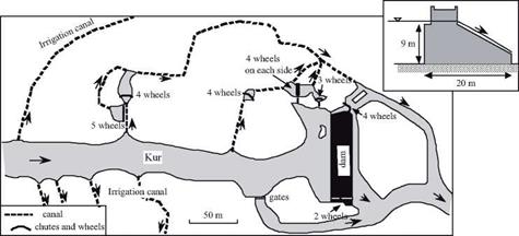
Important rivers such as the Karun and the Kur rise in the Zagros and Fars moun­tains of southern Persia. Rather typical hydraulic works are constructed along the Karun, constituting masonry overflow weirs combined with bridges, beginning in the Sassanide period. Foremost among these is the 520-m long weir built by Roman pris­oners around 260 AD after the capture of the Emperor Valerius. These projects typical­ly raise the river level to supply irrigation canals. But in addition, beginning in the Arab period, they supply water to batteries of mills, or norias. The Amir and Feizabad dams on the river Kur, near Shiraz in Fars, are 9 and 7 meters high and 103 and 222 meters long, respectively. These dams are equipped with an impressive number of water mills: no less than 30 for the Amir (Figure 7.4) and 22 for the Feizabad. These mills have hor­izontal wheels on vertical axes, and are driven by water falling vertically onto their blades:[312]

“Adud al-Dawla closed off the river, between Shiraz and Istakhr, with a great wall, reinforced with lead. The water that accumulated behind this dam formed a great lake. Above this lake, on its two sides, there are hydraulic wheels like those that we have mentioned in Khuzistan. Below each wheel, there is a mill, and today this is one of the marvels of Fars. Later, he con­structed a city. Water flows through canals and irrigates 300 villages in the valley.”[313]

Water resources for Persia and the silk road

Figure 7.4 The Amir installation on the Kor river, in Fars (10th century) and its thirty water wheels (after Schnitter, 1994).

The regions of Bukhara and Samarcand are to the northeast of Khorassan, between the Oxus and Iaxartes rivers. If Khorassan is the land of qanats, Bactria and Sodgiana are the lands of gravity irrigation, through river water diverted into canals by small hydraulic structures. This practice in the Oxus basin stems from the Bronze Age (Figure 2.30), and becomes fully developed in the Greek kingdom of Bactria, then under the Kuchans, between the 3rd century BC and the 2nd century AD. Samarcand solidifies its identity as a great commercial crossroads in the silk trade from this time on. Around Samarcand and Bukhara irrigation networks originating from the Zeravchan River branch out over tens of kilometers.

Ancient Samarcand is located on high ground, and benefits from an advanced water – supply system – a conduit forming a siphon that is destroyed during the siege of the city by the Mongols of Ghengis Khan, in 1219. The city is rebuilt right on the river banks, making it possible to use norias to provide water for the city and its gardens. Ibn Battuta visits Samarcand around 1335, a little more than a century after its pillage. Even though the ruins remain visible, it has clearly become a beautiful city once again:

“… I reached Samarcand, one of the geatest cities, the most beautiful and the most superb. It is located on the wadi al-Qassarin (River of the Fullers) on which there are hydraulic wheels for irrigation of the gardens. The inhabitants get together, after prayers, to stroll and amuse themselves along the banks of the river where one can see benches and seats for resting, and stands that sell fruits and other consumables. Formerly there were, along the banks, imposing palaces and edifices that lead one to imagine the ambition of the inhabitants of Samarcand. But most of these were destroyed, as was a large part of the city [….]. In the city, one can see gardens.”[314]

Samarcand is known for the quality of its paper. Fullers (water hammers that shred and mash linen cloth to produce fiber for paper protection) powered by hydraulic force lend their name to the small river that feeds them, River of the Fullers, a tribu­tary of the Zeravchan. Strong Turk-Mongol regimes launch their raids on surrounding lands from central Asia, where they also develop some new water resources. In the 11th century, the Ghaznavid Turks build two dams in the Samarcand region, 8 and 15 meters high, and 25 and 52 meters long. They also build another larger structure 23 km to the north of their capital city Ghazni, in the region of present-day Kabul; it is 32 meters high and 220 meters long. The Seljuk Turks who succeed them rebuild a dam at Marw on the Murgab River to provide water for the oasis, a dam that will be rebuilt yet again by the Timurids so the oasis can be repopulated.[315] [316] In the 14th cen­tury, Tamerlan and his successors establish Samarcand as the capital of a great central Asian kingdom, and build still more dams in the regions of Teheran, Kashan, Tabas and especially near the new city of Mashadd (not far from Nishapur), present-day cap­ital of Khorasan. Near Kebar and Tabas are three arch dams, among the first known to exist after the few Roman and Byzantine arch structures. The largest, 50 km to the

southeast of Tabas, is 28 meters long and 60 meters high, a record that is destined to

18

stand for quite a long time.

Hydraulic works in medieval India

Dams for control of river flow and for irrigation are also built on the Indian subcontinent itself. One of the oldest of the important dams in India is an earthen structure built about 150 AD on the Kaviri River in the southern region of Cola. This dam, 330 m long and 18m wide, is rebuilt in the 11th century. River traffic is important along the great rivers of central India – the Ganges and the Indus. Later on, the Hindu civilization takes refuge in the south of India when the Turks occupy the north of the country. From the 9th to the 12th century, in particular, the maritime empire of the Cola unifies all the south of India, even temporarily occupying Ceylon. Numerous dams are built, probably under the influence of the earlier developments in Ceylon. One can identify some fifteen important dams dating from the 11th to the 16th century, generally ranging in height from 9 to 24 m and several hundred meters long; however one of them is no less 16 km [302] in length.4 As in Ceylon, these are all earthen dams.

The Indians are good mathematicians (they invented algebra). But ancient Indian writings show few innovations in the domain of physics, which remains aligned with the Greek theory of the four elements.[303] Indian intellectual efforts were more focused on medicine than physics.

In the north of India, the 13th and 14th centuries witness the development of the infrastructures of Delhi,[304] capital of Turkish sultanate between 1192 and 1388. The ini­tial site of the capital being far from the river, the city constructs very large open reser­voirs, and directs storm runoff to them through canals. The inhabitants then get their water from these reservoirs. A new site closer to the river Jamuna is chosen for the city between 1320 and 1325. Although a dam and dike are constructed to create a reservoir for this new location, the site is abandoned even before being occupied. The original site of Delhi remains occupied, despite the inconvenience of its distance from the river. Therefore the city continues to depend on its reservoirs. The account of Tangerian Ibn Battuta, who lived in Delhi between 1335 and 1341, gives some idea of the scale of these reservoirs, as well as a sense of their fragility:

“Outside Delhi, one can see an enormous basin that carries the name of the sultan Shams ad­din Lalmish and serves a supply of potable water for the inhabitants of the city. [….] This basin is two milles (3.5 km) long and half that distance in width. The western part, next to the musalla (a place of prayer), is made of stones that are laid in steps like benches at differ­ent heights. Under each “bench” are steps that enable one to get to the water. Beside each “bench” one sees an enormous cupola with seats for those taking walks or others who are just relaxing. In the interior of the basin there is a grand cupola two stories in height, made of sculpted stone. [….] When the basin is dry, sugar cane is grown along the edges, as well as cucumbers. [….] Between Delhi and the residence of the caliph is the basin al-Khasa, even larger than that of the sultan Shams ad-din. It has nearly forty cupolas around its edge.”[305]

Still later the city of Delhi is moved onto the banks of the Jamuna, under the sultan Firuz Shah (1351-1388) because the maintenance of the canals and reservoirs was judged to have become too burdensome. Along with the move came construction of a great bridge-dam on one arm of this river, as well as irrigation works. In the end all these efforts are in vain, for Delhi is razed by the Mongols of Tamerlan in 1398, ten years after the death of Firuz Shah.