Category Water Engineering in Ancient Civilizations. 5,000 Years of History

The transport canals – the magic canal (Lingqu)

In the very same year that the Zhengguo canal came into service, a twelve-year-old child named Zheng ascends to the throne of Qin. Because of all the irrigation works, he soon inherits unprecedented economic power, and he becomes the first emperor.

In 225 BC Zheng uses the Hong canal for the supply of grain to his army, during his gradual advances toward the south.[399] [400] The main grain storage and distribution center becomes established at the junction of this canal and the Yellow River. Later, this virtu­al nerve center will become the imperial granary.

The victory of Zheng over the Chu ends the warring states period in 221 BC. The conqueror takes the imperial name of Shi Huangdi (or Che Houang-ti). His empire includes, in rough terms, the basins of the middle and lower courses of the Yellow River (Huang) and of the Yangtze.

The emperor, seeking to extend the empire even further to the south and conquer the land of Yue (the region of Canton), plans a fluvial assault using oar-powered military junks fitted with attack towers. In 219 BC, he decides to dig a navigation canal both to transport the army and to carry its provisions.

“… the emperor sent the military commander Tu Sui with a force of men in towered ships to sail south and attack the hundred tribes ofYue, and ordered the supervisor Lu to dig a canal to transport supplies for the men so that they could penetrate deep into the region of Yue.”[401] [402]

However the land is mountainous between the Yangtze and the Xi, the river that flows into the Canton sea. The chosen passage is the Xiang river, a southern tributary of the Yangtze that is connected to it through the grand lake Dongling. The Lingqu canal (magic canal) is therefore opened between the Xiang, flowing toward the north, and the Gui (or Kwei), a tributary of the Xi that flows southerly. The canal follows the course

The transport canals - the magic canal (Lingqu)

Figure 8.6 The hydraulic works realized by the Qin in south China. The layout of the branched canals in the Chengdu region is taken from the map of von Richthofen (1877).

of the Li, a minor tributary of the Gui (Figure 8.6).38

An intake on the Xiang River at Xing’an supplies an artificial canal that has an almost horizontal bed, with just enough slope to convey a discharge that is 30% that of the Xiang. This canal flows for about 5 kilometers, to a point near the source of the Li.[403] The Li is channelized to support navigation along some thirty kilometers of its length, as far as the confluence of this small river with the Gui. Alongside the Xiang there is a lateral canal about 3 kilometers long, and with a very modest section: 1 to 2 m deep, and 5 to 8 m wide.

The Xiang intake structure on the Xing’an is obviously inspired by the one built sev­eral decades earlier on the Min River. It includes a separation structure downstream of a dam-spillway in the form of a V. This complex is designed to raise the water level to provide for flow into the canal, and to create a basin in which the current is sufficiently weak to allow boats to be maneuvered – while at the same time providing for the evac­uation of flood waters into the ancient bed of the Xiang. This 3.9-m high dam is called the Tianping dam. Several other weirs on the canal itself provide for further regulation of the water level as well as for floodwater overflow, as explained in the following 12th century description:

“The passengers who travel (on the canal) are terrified at certain locations for, at about 2 li (1 km) from the intake where the “spade head” divides the water and guides one of the branches toward the canal, there is another weir (literally: structure that lets excess water leave). Without this weir, the violent force of the springtime flow would damage the canal’s support wall, and the water would never get to the south. Thanks to this structure, the violence of the water is calmed, the dike is not broken, and the water in the canal flows gently. [….] This is truly what one can call an ingenious device. The canal waters wind around in the district of Xing’an, and people use it to irrigate their fields.”[404]

The transport canals - the magic canal (Lingqu)

Figure 8.7 The magic canal (Lingqu), communication link between the Yangtze and the Xi (map from Needham, Ling, Gwei-Djen, 1971, detailed plan adapted from Zheng (1991) and Schnitter (1994)). The detail of the installation at the right may not be as it was built under Shi Huangdi, for it underwent important renovations in 825 AD under the Tang.

Later on another navigable channel is dug behind the separation structure to facilitate the turning of barges and their passage from one canal to the other (Figure 8.7).

The magic canal is renovated in 825 AD and fitted with single gates (flush locks, a system we discuss further on) on the two canals and possibly also on the channelized Li, to maintain navigability during low-water periods. These flush locks are probably replaced in the 12th century by true chamber locks, with 36 openings in all. The canal is destined to remain in service through all of Chinese history, right up to the present. The completion of this project, along with the canals that had already been created dur­ing the feudal period, created a continuous watercourse – though indirect – that links Canton to Chang’an through the Xi, the Li, the Xiang, the Yangtze, the Huai, and then the Yellow River and the Wei canal.

The Zhengguo irrigation canal, in the basin of the Wei

Later on, probably around 250 BC, the king of the state of Hann felt menaced by the expansion of the Qin. He sought to deflect the warlike ideas of the Qin by turning his dangerous neighbor’s energy toward peaceful projects:

“The state of Hann, learning that the state of Qin was fond of undertaking large projects, dis­patched a water engineer named Zheng Guo to go to Qin and persuade the ruler to construct a canal from a point of the Jing river west of Mt Zhong to the pass at Hukou, and from there along the Northern Mountains east into the Luo River, a distance of over 300 li. Ostensibly the purpose of the project was to provide irrigation for the fields, though in fact Zheng Guo and the rulers of Hann hoped thereby to wear out the energies of the state of Qin so that it would not march east to attack Hann. Zheng Guo succeeded in getting the project started, but halfway through the real nature of the mission came to light. (…)

“The Qin ruler, deciding that this (the argumentation of Zheng Guo that the canal would ben­efit to the Qin) was sensible, in the end allowed him to go ahead with the canal. When it was finished, it was used to spread muddy, silt-laden water over more than 40,000 qing of land which up until this time had been very brackish, bringing the yield of the land up to one zhong

per acre (mu). As a result the area within the pass was converted into fertile land and no

longer suffered from lean years; Qin became rich and powerful and eventually was able to

3 5

conquer all the other feudal lords and unite the empire.”33

This canal, put into service in 246 BC, is more than 150 km long, and links the Jing to the Luo in Shaanxi (Figure 8.8). It is called the Zhengguo canal in honor of its builder, and supplies numerous secondary canals that provide gravity irrigation for the entire lower region. The canal has been rebuilt several times, even recently, with new intakes further up the course of the Jing to account for the progressive degradation of the river bed and the sediment deposits in the canal itself.

The irrigation system in the Min valley, Sechuan

In 316 BC the Qin occupy the land of Shu, in the southwest, as far as the middle course of the Yangtze river. They developed the basin of the Min River, a tributary of the Yangtze in the Sechuan depression. In the region of present-day Chengdu, they implement a gigan­tic program of irrigation works. Sima Qian mentions this project – all too briefly:

“In Shu, Li Bing, the governor of Shu, cuts back the Li Escarpment to control the ravages of

the Mo (Min?) River and also opened up channels for the Two Rivers through the region of 33

Chengdu.”

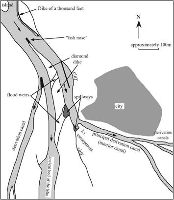
The crown jewel of this project is a remarkable intake structure on the Min (Figure 8.4),[398] near the city of Dujiangyan (earlier Guanseian). It includes a main dike (the dike of a thousand feet) that directs the current toward a structure built of large stone blocks, called the fish nose, that divides the river flow into two portions. The resulting two main channels are separated by the diamond dike whose crest is above the level of the floods, then by overflow structures that make it possible to spill floodwaters from the left chan­nel (whose bed is higher) toward the right channel, which occupies the ancient river bed.

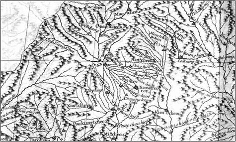
The left channel, or interior channel, is cut into rock across the hill that is some sixty meters in height, and on which the city of Dujiangyan is situated. Sima Qian speaks of the part of this hill that is isolated by the cut called the escarpment of Li. Further down­stream, along this same channel, numerous intake structures direct irrigation water toward Chengdu and the plain of Sechuan (Figure 8.5).

Подпись: Figure 8.4 The intake structure on the Min River at Dujiangyan, origin of the irrigation system of the Chengdu plain at Sechuan (after Needham, Ling, Gwei-Djen, 1971).
The irrigation system in the Min valley, Sechuan

It was surely Li Bing, the designer of the project, who also planned for its mainte­nance. During the low-water period from mid-October to the end of March the canals are cleaned out and the heights of weirs and dikes are brought back to their original lev­els. This maintenance requires that the two arms of the river be alternately dewatered with portable wood dams. In addition at regular intervals the fish nose, the main struc-

ture separating the two channels, is maintained.

Li Biing, along with his son who finished these works, is viewed as a benefactor by the inhabitants of the region. He becomes immortal; at the very top of the escarpment of Li, a Taoist temple is consecrated to him.

The irrigation system in the Min valley, Sechuan

Figure 8.5 The irrigation canals of the Chengdu region, detail from a map established by the Jesuits of the 18th century (Du Halde, 1735 – ancient archives of ENPC).

Hydraulic development and rise of the Qin kingdom (4th and 3rd centuries BC)

The kingdom of Qin, rising from the western valley of the Wei, begins to grow from 350 BC. Its leaders are tough, uninterested in moderate discourse and Confucian scholarship. In 417 BC they had occupied Lin-Tsin, one of the centers of the cult of the Yellow River at its confluence with the Luo (the other center of the cult was at Ye where Ximen Bao had put an end to the human sacrifices at about the same time). Since the Qin desired the river god’s protection for their family, each year they sacrificed a princess in “marriage.”[396] [397] The methods of the Qin were radical, one could even say bloodthirsty. But their leaders well understood the importance, to their own power, of economic development of the regions under their control. They had a marvelous understanding of how to com­bine development with territorial expansion.

The three projects that we describe below are destined to have an extraordinary future – they remain in service today after more than 2,000 years of uninterrupted use.

The first large transport canals of the 5th century BC

Irrigation and drainage make it possible to develop cultivated land, as we have seen. In addition, the transport of bulk matter (especially grains) relies mainly on canals. Therefore it is typical to find dense networks of irrigation canals branching out from main transport canals during the major kingdoms. The following text of Sima Qian gives us an idea of the scale:

“Sometimes later (up to this point the text speaks of the works of Yu the Great) the Hong Canal was constructed, leading off from the lower reaches of the Yellow River at Xingyang, passing through the states of Song, Zheng, Chen, Cai, Cao, and Wey, and joining up with the Ji, Ru, Huai, and Si rivers. In Chu two canals were built, one in the west from the Han River through the plains of Yunneng, and one in the east to connect the Yangzhe and Huai rivers. In Wu a canal was dug to connect the three mouths of the Yangzhe and the Five Lakes, and in Qi one between the Zi and Ji rivers. (…)

“All of these canals were navigable by boat, and whenever there was an overflow of water it was used for irrigation purposes, so that the people gained great benefit from them. In addition, there were literally millions of smaller canals which led off from the larger ones at numerous points along their courses and were employed to irrigate an increasingly large area of land…. u

Let us look more closely at one of these projects. The most impressive transport canal in this period is the Hong canal, or canal of the wild geese. This is in fact a sys­tem of canals linking the Yellow River, from a city called Xingyang (or Jungyang) near the present-day Kaifeng, to the Ji River that flows to the north of the Shandong moun­tains but whose origin is quite near, and to the tributaries of the north bank of the Huai river. The canal has two main branches (Figure 8.3). The north branch (or Bian canal), the one most used for transport, probably follows the course of the ancient Bian (or Pien) river, which rejoins the Si and the Huai. This is a watercourse some 900 km long, sure­ly artificial along a portion of its course. The south branch (the Langtanqu canal) links the Ying, Sui and Kuo rivers at their origins. It is some 400 km long, and constitutes a second fluvial passage between the Yellow River and the Huai,[395] through the Ying River which is navigable. The lengths of these canals are impressive, even though the origi­nally swampy terrain is practically flat between the Yellow River and the Huai. At the beginning, the Hong canal may have simply been a collection of irrigation canals for the north basin of the Huai.

The date of construction of the Hong canal is uncertain. As we have seen, when Sima Qian cites this canal as the very first in his list, he describes the regions linked by this pathway using names that refer to the period of springs and autumns. Moreover, Joseph Needham indicates that the Hong canal is mentioned around 330 BC in the account of a diplomat in his discussions of the boundaries between states. So, should we follow those who suppose that the canal dates from the 6th or 5th century BC? The con­struction of a work of such scale implies a strong central power and an economic moti­vation for exchanges between the basins of the two rivers. The coexistence of these fac­tors would seem problematic in the troubled period from the 5th to the 3rd centuries BC.

The Hong canal is destined to be well maintained, and remains in use in its original course up until 600 AD. Another important project in Sima Qian’s list is the Han canal, linking the Huai and the Yangtze. The king of the southern state of Wu has it built in 486 BC to supply his troops who were on a campaign against his northern neighbors.

From fear of the Yellow River to the first grand irrigation projects (7th to 5th centuries BC)

The first large dike construction projects on the lower course of the Yellow River date from the spring and autumn period, more precisely the first half of the 7th century BC. The duke Huan de Qi is said to have brought together the “nine rivers” described by Sima Qian into a single course and probably tried to drain the swampy plain.[388] Soon after came the first realignment of the river course mentioned in Chinese history. In 602 BC the river adopted a new course some hundred kilometers to the east (Figure 8.2). Fortunately, the region affected by this first event was probably not very populated. The north of the allu­vial plain does not begin to see real development until the beginning of the warring states period (in the 5th and 4th centuries BC) when the Qi enters a new era of great prosperity. This will become one of the most active agricultural regions under the Qin and the Han.

The Yellow River is intensely present in Chinese thought during the feudal period; it is worshipped like a god. In some places a young girl is sacrificed to the river each year, such as at Ye, on the ancient course of the river that flows toward the north[389] in the Handan region (Figure 8.3). The girl is chosen by witches of the cult of the river, adorned as for marriage, placed on a wedding bed, then launched onto the river where the bed floats for a brief time, then sinks to drown the sacrificial maiden.[390] A certain Ximen Bao, a disciple of Confucius, was responsible for ending this practice. This end occurred under the enlightened reign of the duke Wen of the Wei kingdom (424 – 387 BC), a period during which this kingdom reached its apogee. We cannot resist the temp­tation to share the account of this event:

“Ximen Bao, having arrived in Ye, called together the notables and asked to learn about the custom that was desolating the county; marrying girls to the Lord of the River; the ceremony was described to him; he asked that he be told, without fail, of the day the festival would take place. When the day came, he and his soldiers went to the site of the sacrifice and announced that he came to be sure that a beautiful girl was chosen for the Lord. He looked at the girl chosen for sacrifice and declared to the grand wizard and to the elder of the country that the girl was not at all beautiful: he then sent the wizard to warn the Lord of the River that there was a mistake, that another would be chosen and that the ceremony was put off. The soldiers then threw the grand wizard into the river. Ximen Bao waited for a moment and, when the grand wizard did not come back from his mission, he threw an apprentice wizard into the river, then, when he did not return, a second apprentice, and finally a third. He then had the elder thrown into the river, and he did not return either. [….] Ximen Bao

From fear of the Yellow River to the first grand irrigation projects (7th to 5th centuries BC)

Figure 8.3 The basins of the Yellow River and the Blue River, from the time of the Warring States up to the early Han Empire. The underlined upper-case names refer to these states after 350 BC. The underlined names in italics refer to the regions, more ancient, of the Spring and Autumn period. Grand irrigation projects of the feudal period:

Irrig 1: between the Jiang and the Yellow Rivers (Ximen Bao)

Irrig 2: Zhengguo canal and derivation canals (Zheng Guo)

Irrig 3: Min basin – Figures 8.5 and 8.6 (Li Bing)

then stopped the ceremony and no one dared speak of resuming it.”[391]

Ximen Bao is also known for the development of irrigation in the Ye region, on the lower slopes of the Thaihang mountains. Around 410 BC he had dug what amounts to a canal fed by the Jiang (an earlier tributary of the Yellow River), rising toward the north­east on a course parallel to and above that of the ancient bed of the Yellow River. Secondary canals then provided for gravity irrigation of all the region between this der­ivation and the Yellow River, a region that becomes particularly prosperous according to Sima Qian.[392]

Further to the south the first dam-reservoir known in China is constructed around 585 BC, in the state of Chu. It is intended to support irrigation, and is attributed to the minister Sun Shuao. The earthen dam is reinforced with layers of straw and wooden stakes. The dam was originally called the Shaobei (dam of the Peony flower), but it is known today as the Anfengtang, for it is still in service. It blocks a large valley of rather gradual relief into which flow two southern tributaries of the Huai, coming down from the mountains that separate the valley of the Hua from that of the Yangtze.[393] [394]

The Yellow River, a terrible friend

The first historical treatise from China dates from around 100 BC. This is the work of Sima Qian,[382] who had an official position in the court of the Emperor Wudi of the Hans at the beginning of the imperial era. Sima Qian revived and perpetuated the legendary attribution of the ancient course of the Yellow River to Yu the Great, undoubtedly with some measure of exaggeration. He gives us a rather precise description of the ancient course (Figures 8.2 and 8.3):

“The documents of the Xia Dynasty tell us that Emperor Yu spent thirteen years controlling and bringing an end to the floods and during that period, though he passed by the very gate of his own house, he did not take the time to enter.

Of all the rivers, the Yellow River caused the greatest damage to China by overflowing its banks and inundating the land, and therefore he turned all his attention to controlling it. Thus he led the Yellow River in a course from Jishi past Longmen and south to the northern side of mount Hua; from there eastward along the foot of Dizhu mountain past the Meng ford and the confluence of the Lo River to Dapei. At this point Emperor Yu decided that since the river was descending from high ground and the flow of the water was rapid and fierce, it would be dif­ficult to guide it over level ground without danger of frequent disastrous breakthroughs. He therefore divided the flow into two channels, leading it along the higher ground to the north, past the Jiang River and so to Dalu. There he spread it out to form the Nine Rivers, brought it together again to make the backward flowing river (this is the lower portion of the river which has tidal influence), and thence led it into the gulf of Bohai.”[383]

The reader may note that the great historian recognizes the hydraulic consequences of the change of slope where the river flows out onto the plain, as well as the effects of the tide. These were surely personal observations, for Sima Qian had traveled all across China.

The Yellow River owes its name to the color of the sediments it carries. During floods it is nearly a river of mud, having one of the world’s highest concentrations of sediment. Nearly 5,500 km long, in its middle reaches it flows for 1,200 km across a plateau of loess, carrying fine sediments deposited by the wind. Once the river arrives on the plain, its bed slope suddenly decreases and the water velocity is consequently reduced, as is noted by our historian.[384] [385] As the water velocity decreases, the particles in suspension deposit onto the bed.

Since very early times the Chinese have constructed dikes to protect villages and fer­tile lands from the floods. The deposited sediments accumulate between these dikes, and

21

this of course raises the bed of the river relative to the plain surrounding it. Quite

rightly, Chinese tradition emphasizes both the importance of dredging the riverbed dur­ing low-water periods and the importance of building dikes. As we have seen in Chapter 1, it was in dredging the bed of the river that Yu succeeded in conquering the waters; his father Kouen, who only built dikes, had failed in trying to contain the river.

Failure to dredge the riverbed inexorably ends up causing an overflow and dike rup­ture. The river flows onto the plain with consequences that one can easily imagine, and it may then wander over large distances and establish a new course completely different from that in which it had formerly been contained by dikes. There have been nearly

2,0 dike ruptures recognized in Chinese history up to the present time, during which the course of the Yellow River has undergone 26 significant changes.[386] Over the course of history, the irrigated and fertile plain has become more and more densely populated – and therefore the consequences of inundation become more and more serious.

The Yellow River, a terrible friend

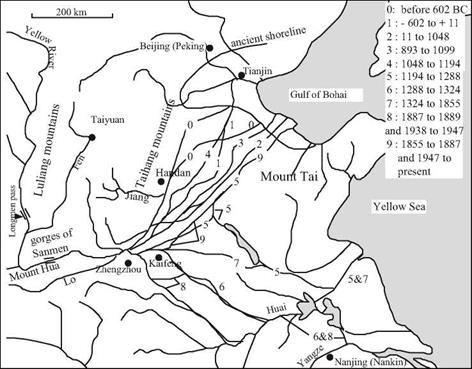
Figure 8.2 The principal historical courses of the Yellow River. N. B. Between 168 and 132 BC, the river flows into the Huai to the south. Moreover, courses 2 and 3 most often comprised two distinct arms each. Finally, it is probable that courses 5 and 7 existed since 1187, and that courses 5 and 6 functioned up until 1495. Other temporary arms are not shown on this map.

The principal flood events took place between the 2nd century BC and the beginning of the Christian era (Figure 8.9), then again between the 11th and the 14th centuries, when the Yellow River flowed to the south of Shandong and joined the Huai. It is not until the 19th century that the river comes back to the north, in the bed of the Ji river. From the beginning of the Qin and Han Empires, Chinese history records multiple examples of populations that are ruined and displaced by floods, eventually to be resettled by the cen­tral authority in colonized regions at the edges of their former domains.[387]

Irrigation and transport works in the feudal period

Historical and cultural landmarks

The Bronze Age begins with the Shang Dynasty, succeeding the Xia Dynasty about 1600 BC. This aristocratic and cruel regime is well known in archaeology; the first texts scratched in bone come from it. The influence of this dynasty is limited to the valley of the Yellow river to Shandong. Then about 1100 BC the Zhou, coming from the valley of the Wei (a tributary of the Yellow River in Shaanxi) supplant the Shangs. Under their more humane domination the Chinese civilization reaches not only further to the north, but also and especially toward the south as far as the Yangtze valley. The Zhou estab­lish their capital near Luoyang where the river flows out onto the plain. But the Zhou regime does not have a structure that is capable of coping with the growth of their domain. Several centuries after their advent, provincial powers begin to rival the influ­ence of the central power. This marks the onset of the feudal period, beginning with what is called the Spring and Autumn period (771 – 480 BC) and the Warring States peri­od (480 – 221 BC), a rather evocative name indeed.

The major currents of Chinese thought developed during this troubled period.[374] [375] Kong Fuzi, or Confucius lived from 551 to 479 BC and founded a social philosophy that seeks to establish justice and equity in the framework of traditional structures and cus­toms. Confucianism preaches peace, order, and return to the path of the “wise kings of Antiquity”, motivated by the desire to bring well being to the people. Later this becomes the official doctrine of the empire’s administrators, mandarins recruited competitively based on their literary knowledge. The principle disciple of Confucius, Meng Ke, or Mencius, was born in 374 BC and becomes counselor to the princes of the kingdoms of Liang and Qi. He brings the humanist aspects of Confucianism to the forefront: tradi­tions and customs are made for men, and not vice-versa. Opposing this trend of thought, Taoism appears at an indeterminate date during this same period. One of its best-known founders is Laozi (Lao-Tse), who lived in the 4th century BC. Rarely has a philosophy been so caricatured. Nonetheless, it contains the real premises of scientific thought. As a naturalist philosophy, based on observation of natural things, Taoism has as its ideal the search for causes, but without any aspiration to discover at all costs a unique model that might explain everything. Taoist thought, based in observation and experimenta­tion, is more descriptive than explanatory:

“All phenomena have their causes. In the ignorance of these causes, it can happen that one is correct (in regard to the facts), but it is as if one knows nothing, and in the end remains per­plexed. [….] The fact that water exists in the mountains and heads toward the sea does not arise from some antipathy for the mountains, nor from a love for the sea, it is simply due to the effect of altitude such as it is.”11

So, whereas Confucianism is oriented to action, Taoism is the calm search for an interior pathway. Naturally humble, it nonetheless willingly arrays itself against the powerful.

During the feudal period scholars move from one court to another. The more enlightened of the princes of these kingdoms create academies, the most celebrated being at Linzi, the capital of Qi in Shandong.[376] It is from within this academy that Zou Yan (305 – 240 BC), considered by Joseph Needham[377] to be the founder of Chinese sci­entific thought, formulates the theory of the five elements: water, fire, wood, metal, and earth.

“Of the five elements, the first is called Water, the second Fire, the third Wood, the fourth Metal, and the fifth Earth. Water (is the quality in nature) that moistens and tends to sink; Fire (is the quality in nature) that flames and tends to rise. Wood (is the quality in nature) that per­mits curved surfaces or straight edges. Metal (is the quality in nature) that can follow (the shape of a mold) and can harden. Earth (is the quality in nature) that permits sowing, (growth), and harvest.”[378]

This text shows how the Chinese view is something quite different from the Greek the­ory of four elements, popularized at about the same period by Aristotle.[379] The Chinese theory of five elements is not a model intended to explain nature, but rather a classifica­tion of processes or physical properties (Table 8.1). The theory is essentially descrip­tive, consistent with Taoism. It will be used throughout the evolution of Chinese thought, completing the vision well known in the West of competition between the opposing principles ying and yang.

Table 8.1 Correspondence among the five elements of the Chinese literati and a classification of their physical properties.

Element Physical Property

Water

That which is fluid, can flow, and dissolve

Fire

That which emits heat and can burn

Wood

That which is solid and can be shaped (carved)

Metal

That which is solid and can be melted, and which can take the form of a mold

Earth

That which produces useful plants

The first dynasty of the imperial era, that of the Qin, is followed by the long Han Dynasty. The Romans maintained commercial relations with this dynasty and may have even had diplomatic relations.[380] From 221 BC to 190 AD, China knew four centuries of unity.

The feudal period and this first imperial era experience intense economic and demo­graphic development, both supported by hydraulics as we will see further on. The cen­sus of year 2 already reports more than 57 million inhabitants.[381]

The fall of the Han Empire is first followed by a splitting of China into three king­doms (220 to 310 AD) and then by a period of total anarchy (310 to 589 AD). These long centuries of chaos are often called the “Chinese middle ages”. It is in the 3rd cen­tury that Taoism, a philosophy but also an inspirational movement of secret societies, becomes a religion as well. In the 3rd and 4th centuries, Buddhism is introduced and develops in China.

In 589 AD China is reunified under the Sui and Tang dynasties. After a troubled period from 906 to 960 The Song Dynasty is again established, and under it the natural­ist Chinese movement reaches its greatest development. But starting in 1127 the power of the Songs recedes in South China following a series of invasions. From 1271 the Mongols occupy all of China and call themselves the Yuan Dynasty. The Mongol Empire extends from Persia to the Sea of China, naturally favoring commercial relations between China and the Middle East. In 1368 the Mongols are chased out by the Mings following peasant insurrections caused by famine. The Mings are eventually succeeded by the Manchu Qing Dynasty from 1644.

Naturalist Chinese thought is the inheritor of Taoism and excels in the observation and classification of things. But thanks to Confucianism, oriented toward action and often impelled to relieve manual labor, the Chinese invent many devices that spread toward the West. These include the axial rudder, the wheelbarrow, the magnetic com­pass, gunpowder, and the navigation lock. The Chinese excel in hydraulic technology as we will see further on in this chapter. But ancient Chinese science also uses mathe­matics to describe the laws of nature. The Jesuits, who get established in China during the Qing Dynasty in the 17th century, bring with them the methods of modern science.

We have seen that hydraulics is in the fabric of the founding legend of Chinese civ­ilization. Since the very beginning of Chinese history, hydraulic technologies are employed to make new lands productive through irrigation and drainage of swampy val­leys. Hydraulics is also brought to bear on the development of the infrastructure for waterborne transport. But there is no relief from a recurrent curse that returns regular­ly: floods and the associated changing courses of rivers, killing people and ruining entire regions. The inability to stabilize the large rivers, in particular the Yellow River, is often the cause of popular uprisings that end up bringing down dynasties. We therefore pro­ceed to describe this great river, one of the principle actors on the vast stage of China.

From the beginnings of agriculture to the legendary founder of Chinese civ­ilization

Archaeology teaches us that grain cultivation, namely millet, appears in the middle basin of the Yellow River around 6000 BC.[370] [371] [372] Two cultures develop successively in this region: one is called the Yangshao at the end of the VIth millennium BC, during which small- scale farming develops (pork, poultry); the other is the Longshan, at the end of the IIIrd millennium BC, during which wheat and barley develop in addition to millet, and the first fortified villages appear. As a point of reference, recall that this is also the period of the grand civilization of Harappa on the Indus and its extensions in Bactria. The Chinese regions involved are Shaanxi, Shandong and especially Henan and Shanxi. The foundation of Chinese civilization is rooted in the continuity of this culture, localized in

7 v 8

the region of the confluence of the Luo and the Wei rivers with the Yellow River. The legendary hero is Yu the Great who is said to have tamed the unpredictable course of the Yellow River through the construction of canals and deepening of its bed:

“Before him, the overflow waters flowed wantonly”[373]

It is of course, impossible to know if all the accomplishments attributed to Yu result­ed from his efforts, or indeed from human intervention at all. But, given what we know and taking into account the seriousness of the ancient Chinese sources, there is no rea­son to doubt a priori the existence of the personage himself. He would be at the origin of the Xia Dynasty, whose domain scarcely extended beyond the terraces and valleys that mark the terminus of the middle course of the Yellow River. Taking the suggestions of the ancient Chinese historians to their logical conclusions, one ends up dating the leg­endary reign of Yu the Great to around 2200 or 2000 BC.

Civilization in China apparently begins two millennia after it began in Mesopotamia. On the other hand this Chinese civilization is remarkable for its durability, from its earliest beginnings up until the present day.

From the beginnings of agriculture to the legendary founder of Chinese civ­ilization

Figure 8.1. The eastern portion of China, showing the middle and lower courses of the Yellow River (Huanghe) and the Blue River (Yangtze). On this map, the rivercourses, coastlines, and city and province names are those of today. The Grand Canal is not shown.

Rivers, canals, and Hydraulic technology in China

In 329 BC, the army of Alexander the Great conquered Bactria and reached Samarcand, more than 4,000 km from Macedonia. At the same time, on the other side of the deserts of Taklamakan 3,000 km to the east, another warrior kingdom by the name of Qin began an astounding expension. A century later, while Alexandria of the Ptolemites was shin­ing its brightest and while Archimedes was discovering the principles of hydrostatics, this powerful of Qin was unifying an empire that spread across an entire continent. When the name of Qin appeared in the Occident, having passed from mouth to mouth across India, it had been transformed to become what we know as China.1

Relations between China and the Near East – the Silk Road

The worlds of ancient China and the ancient West were never truly isolated, even if direct contacts between them were rare. Recent archaeological discoveries[365] [366] in the desert of Taklamakan in Xinjiang (Chinese Turkestan) reveal a very old settlement of oases through which the Silk Road will later pass. This area had widespread irrigation in the first millennium BC. It is possible that wheat was brought to the Near East and as far as China by this route in the Neolithic period. The same may also be true for the technol­ogy of bronze, as it appeared very suddenly in China about 1600 BC.

In 135 BC an official Chinese envoy named Zhang Qian reaches, with difficulty, the territory of the Yuehzi at the borders of a country called Daxia by the Chinese, thought today to be Bactria.[367] (The Yuehzi later found the Kuchan Empire). There he discovers, among other things, products of South China that reach this country after passing through a region called Shendu (India).[368] In 104 BC a Chinese military expedition estab­lishes effective control over this route, destined soon to become the eastern portion of the Silk Road. The Romans discover silk in the 1st century AD and become infatuated with it. The Parthians begin to serve as intermediaries between the two great empires and before long, caravans begin to link them, through many additional points of contact. These included Palmyra or Antioch to the west, and Chang’an (today Xi’an) in China to the east. Starting in the 2nd century AD, a maritime route passing to the south of India (exploiting the seasonal monsoon winds) establishes a more direct link from east to west. This maritime route is especially used by merchants of Alexandria. It is said that a

Roman diplomatic expedition, likely made up of Syrian merchants, called at ports in South China during the Han Dynasty, successor to the Qin Dynasty.[369] Later on the Arabs serve as intermediaries between the West and China; eventually in the 15th century the Ming Dynasty launches its own junks on grand expeditions.