Category Water Engineering in Ancient Civilizations. 5,000 Years of History

The Grand Canal of the Yuan and the Ming Dynasties

In 1126 the Song were forced to abandon the north of China, pushed out by barbarians who had partially adopted Chinese culture (the Jurchen, or Jin). During their retreat the Song destroy the south-bank dike of the Yellow River in the Kaifeng region, and this causes considerable damage to the Tongji canal and destabilizes the river. For more than three centuries after this the Yellow River will tend to form multiple and unstable branches. Pushed to the south, the Song further destroy hydraulic infrastructure and set up their capital at Hangzhou, at the southern extremity of the Grand Canal. During the period of wars that follows, in about 1190,[432] the river starts to migrate toward the south (Figure 8.2). From this date, part of the discharge in effect bifurcates toward the Huai (note this had already occurred between 132 and 109 BC). First the floodwaters, then the Mongols of Ghenghis Khan, sweep over China. From 1214 to 1276 the Mongols destroy the Jurchen powers, then those of the Song. Their first undertaking is to mas­sacre all the inhabitants, as in Mesopotamia. But in 1271 they take on a more noble role and, under the name of the Yuan Dynasty, reign over an immense empire that extends from the Sea of China to the Euphrates.

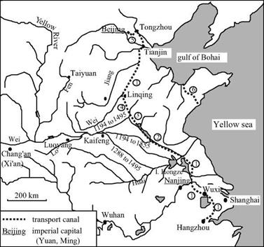
The Yuan chose Beijing for their capital, this being a more central site for their new empire than the ancient capitals of Chang’an, Luoyang and Kaifeng. Just as the Sui had been impelled to construct the first Grand Canal in the 7th century, the Mongols now saw the need to reestablish a large waterway, ideally as a more direct link from Beijing to the Yangtze basin. In 1275 a Mongol general called Bayan was fighting against the Song of the south. He began studies of a canal that would use the north portion of the Grand Canal of the Sui, but would cut directly toward the southeast from Lingqing. This canal would rejoin the arm of the Yellow River that had bifurcated from there toward the Huai since the 1190s (this is course no. 5 in Figure 8.2). Between 1280 and 1283 the Huangong and Jizhou canals were built more or less along the alignment of this arm.

The Jizhou canal takes a shortcut across the foothills of Shandong, and has 31 gates along a distance of nearly 150 kilometers (250 li). These canals make it possible to ship goods from the south up to the bifurcation of the course of the Yellow River, then on the

The Grand Canal of the Yuan and the Ming Dynasties

Figure 8.13 The Grand Canal of the Yuan and the Ming.

1: elements of the Grand Canal of the Sui (renovated between 1280 and 1290)

2: Huangong canal (1280)

3: Jizhou canal (1283, 1411)

4: Huitong canal (1289)

5: Tonghui canal (1293)

6: Jiao-Lai canal

northern course to the Gulf of Bohai from which they continue by sea to Tientsin.

Five years later (1288) the Yellow River abandons its principle course to the north of Shandong (though this branch carries some flow until 1945) and flows out to the south into the Huai, even further upstream than earlier. This course change probably motivat­ed and likely facilitated the completion of the waterway project. Indeed just one year later, in 1289, the Huitong canal – whose design had been studied by general Bayan – is completed in its turn. The totality of the project is completed in 1293 by the Tonghui canal linking the capital Beijing to Tongzhou. This canal had to have some 20 gates, for Beijing is at a higher elevation than the rest of the system. The remainder of the water­way network, whose layout follows that of the first Grand Canal of the Sui and the Song, is simply brought back into service and improved (in 1290 for the channelization of the Wei river.).

Marco Polo sojourns in the court of Kubla Khan in 1280, and probably in 1288-1290 is sent on a mission to the south of China (he returns to Italy in 1298). He writes of the city of Guazhou, at the junction of the Yangtze and the Grand Canal, as follows:

“The city is on the river, and it is there that, every year, vast quantities of rice are collected.

And, from this city, they are transported to the large city of Cambaluc (Beijing), to the court of the Great Khan, by water. But understand this is not by sea, but by rivers and lakes. [….] And I tell you that the Great Khan had these waterways between the two cities brought into service, for he had huge trenches dug, very wide and very deep, from one river to another and one lake to another, and had water transported by canals, so that it all became like one large river, and great ships go on it.”[433]

Marco Polo also speaks of the city of Jining, which is at the junction of the Huangong and Jizhou canals. He notes how the watercourses coming from the heights of Shandong are captured to supply the highest portions of the Canal:

“And I tell you further that they have a river from which they profit immensely and I will tell you how. The truth is that this large river comes from the midlands to this city of Singi Matu (Jining), and the people of the city, from this large river made two; for they sent half toward the rising sun and the other half toward the setting sun, that is to say that one goes toward Mangi (the region of the lower Yangtze) and the other toward the Catai (the region of Beijing). And I tell you truthfully that this city has such grand ships – such a large quantity of boats – that no one could believe it without having seen it. Do not take this to mean that they are large ships: they are of appropriate size for vast rivers. And I tell you that these ships carry to Catai and to Mangi such large masses of merchandise that it is a marvel… .”[434]

Starting in 1327, repeated floods cause serious famines. In 1344, the dikes break downstream of Kaifeng and are not restored until 1349. The plight of the miserable peasants of this region, along with the massive labor conscriptions necessary for the dike repairs, leads to the emergence of the Red Turbans. This secret society soon leads an insurrection against the power of the Mongols.[435]

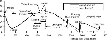
A glance at Figure 8.14 makes it easy to understand the problem of water supply to

The Grand Canal of the Yuan and the Ming Dynasties

Figure 8.14 Longitudinal profile of the Grand Canal, from a modern survey (Needham et al, 1971).

the highest portion of the Grand Canal of the Yuans, i. e. the Jizhou canal in Shandong.

This problem is not solved by the Yuan, who continue to use primarily the maritime route and in effect cut off the Shandong peninsula with the Jiao-Lai canal. It is not until the Ming regime, arising from the insurrection that chased out the Mongols in 1368, that an effective solution to this problem is developed using hydraulic works. In 1411,

165,0 people are put to work on the 200-day construction of a dam-reservoir that could assure a sufficient supply of water to maintain the supply to the Jizhou canal throughout the year. Other small reservoirs are constructed near the canal’s locks, which were also rebuilt at this time.

Under the Ming the strategy adopted for control of the Yellow River consisted in preventing any return of the course toward the north through construction of a very long dike, stretching for several hundreds of kilometers. Systems of multiple dikes delimit­ing the flood plain were also constructed. A real strategy for sediment management was put into place. This strategy combined deposition in flood-plain zones managed for this purpose with narrower channels in which the strength of the current was sufficient to prevent deposition. Starting in 1495 the course of the river was finally stabilized, as shown on course no. 7 of Figure 8.2.

Important canal rehabilitation work took place in 1528, still under the Ming, in par­ticular separating the bed of the Grand Canal from that of the Yellow River. Piracy was developing along the shores of the Sea of China at this time, rendering more indispensa­ble than ever the use of the grand artery between the south and north of the country.

It was also during this period that work was done on the Hongze lake. This lake had probably been just a natural flood plain for the southern course of the Yellow River up to then. This zone was transformed into a permanent reservoir of increased volume through construction of a large north-south dike delimiting the eastern bank of the lake over more than 30 km, in 1578.[436] An engineer called Pai Jixun led this work; he was also known for his work on control of Yellow River sediments. At the beginning of the Manchu domination (1660) this dike is extended to a total length of 67 km and its height is raised 1.5 m to attain a maximum of 7 m. The structure itself is a masonry wall whose stones are tied together by steel tendrils. The wall is about 1 m thick and supported by an earthen embankment, and rests on a foundation of piles.

In the 14th and 15th centuries the Grand Canal evolves to a configuration that is essentially the same as today. Its total length of about 1,700 km makes it the largest hydraulic project ever constructed by man. We earlier saw how travelers at the begin­ning of the 14th century had been impressed by the Grand Canal of the Yuan. Three cen­turies later another westerner embarks upon the Grand Canal. This is father Matteo Ricci, the founder of the Jesuit missions in China, who traveled from Nanjing to Beijing between September 1597 and February 1598. Being a scientist, he begins by describing the overall fluvial system:

“This river of Nanjing (the Yangtze) goes from Nanjing to the north; then, returning somewhat toward the midlands, flows with great impetuosity into the sea. [….] This is why, to be able to go by water into the royal court of Beijing, the kings of China drew a large canal from this river to another, that is called Yellow. [….] This river [….] as if in revenge for the hate that the Chinese carry to foreigners, very often spoils a large part of the kingdom through its large floods and changes its channel as it pleases, when it is filled with sand that it carries along.”[437]

This latter account reveals the isolationism that characterizes the end of the Ming Dynasty. In following sections of his treatise Matteo Ricci gives a very vivid descrip­tion of the traffic on the upper portions of the Grand Canal, as well as of passages through the flush locks. He also mentions the inclined planes on which boats are dragged using capstans. He does not mention any chamber locks.

“And, however, the multitude of vessels is so excessive that the ships, each blocking the oth­ers, are often obliged to wait several days to pass, principally in certain times when there is not enough water in the canals. To solve this, they hold back water in several places with locks of wood, which also, to serve two purposes, are installed as bridges. These locks, when the stream is full, are opened and the boats are carried by the force of the running water. And, thus, the sailors navigate from lock to lock with great difficulty and along a tiresomely long route. The work is made even more difficult since it is very infrequent that, in the narrow strait of the stream, the winds are favorable for the vessels. This is why, ordinarily one uses ropes to advance along the canal and even, it often happens that at the entrance or exit from the locks, when waves rising up like impetuous whirlwinds come to envelope the boats, they are lost in the canals drowning all those who were within. But the ships of magistrates or princi­pals are pulled against the water with machines of wood; and this happens along all the route at the expense of the King.”[438]

Reading this account, one can understand what led Chiao Wei-Ho to invent the chamber lock in the 10th century. It is more difficult to understand why this process is not used in the upper reaches of the Grand Canal of the Yuan and the Ming. Does this

The Grand Canal of the Yuan and the Ming Dynasties

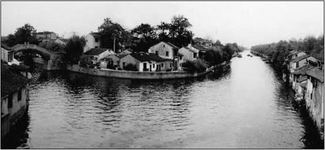
Figure 8.15 An ancient stretch of the Grand Canal (Jiangnan canal) at Wuxi (photo by the author)

perhaps mark the beginning of the decline in the spirit of innovation that will character­ize the 17th and 18th centuries?

This is a good time to note the influence of inland water transport on urbanism. Certain cities along the Grand Canal are virtual “Chinese Venices” (Figure 8.16). We can illustrate this through the Venetian Marco Polo’s description of the city of Hangzhou (Han-Tcheou). In the 13th century this city becomes the capital of the Song when they retreat to the south. With nearly one and a half million inhabitants,[439] it is also perhaps the largest city in the world (along with Baghdad before the passage of the Mongols): “It (the city of Hangzhou) is situated in such a manner that it has, on one side, a freshwater lake that is very clear, and, on the other side, an enormous river that, entering in many canals from small to large and flowing through all the districts of the city, carries all the filth, then penetrates into the lake and, from there, flows toward the ocean. This makes the air very healthy. One can visit all the city both on land and on the water. The streets and canals are long and wide, so much so that boats can navigate on them as they please. [….] No one should be surprised to see so many bridges; because I tell you that this city is entirely on the water and surrounded by water. [….] On the other side of the city is a trench that is perhaps forty milles in length, enclosing the city on that side; it is very wide and completely full of water from the aforementioned river. This was done by order of the ancient kings of the province, to be able to redirect the river each time it overflows the dikes.”[440]

The appearance of the chamber lock

The chamber lock, with two gates, is invented in the Song Dynasty at the end of the 10th century. In 983, a civil servant named Chiao Wei-Yo is in charge of transport in the Huai region. At this time barges were transferred from the canal to the Huai, at the northern extremity of the Shangyang traverse, by dragging them on an inclined ramp. This oper­ation often damaged the heavily-loaded barges and their cargo. To remedy this difficul­ty, Chiao Wei-Yo conceived the concept of the chamber lock, the very first such device in the history of man:

“Chiao Wei-Ho therefore ordered the construction of two gates at the third dam along the west river. The distance between these two gates was a little more than 50 paces (75 m) and the entire space was covered with a large roof. [….] When the gates were closed, water accumu­lated like the tide until the desired level was attained, then, when the right moment arrived, it was allowed to flow out.”[430]

Additional evidence of the appearance of the chamber lock comes from the magic canal, linking the basins of the Yangtze and the Xi to the south. Joseph Needham notes that up until the 9th century, written accounts mention 18 single gates on this canal, and that from the year 1178 the number increases to 36. He interprets this doubling as the replacement of the single-gate flush locks by chamber locks with two gates. A later account dating from the 16th century also suggests the existence of chamber locks on this canal:

“On the Ling Chhh (Lingqu – magic canal) north to south there are 32 lock-gates, i. e. from the Li to the Thung-Ku Shui. From east to west, entering Yung-fu, there are 6. In the winter (the canal) dries up and one cannot pass through. But when I made the passage through these lock – gates there was plenty of water, and under the moonlight they looked like steps leading up to some high platform, or like tiers of walls and terraces coming down one behind another from the sky.”[431]

The chamber lock is a Chinese invention that does not appear in Europe until the 14th century. In China itself this invention will have a somewhat murky future, since, as we will see, the old principle of the flush lock will remain in broad use on the Grand Canal for some time to come.

The Grand Canal

The Grand Canal of the Sui, the Tang, and the Song (6th to 11th century)

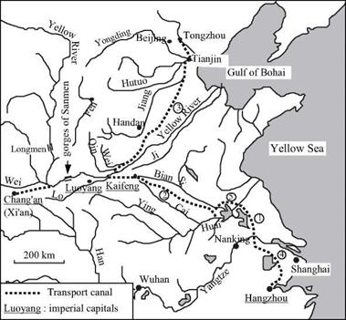
In 581 AD, Yang Jian founded the Sui Dynasty at Chang’an. He reunifies China in 589, and in 604 the country sees its new master enthroned as emperor. An imperial necessi­ty appears immediately: to establish a safe communication route between the north of China where the reconstructed capital Chang’an is located, and the Yangtze basin to the south. This need reflects a fundamental change in the relations between north and south

The Grand Canal

Figure 8.12 The Grand Canal of the Sui, the Tang and the Song.

1. Shanyang traverse (renovated in 587)

2. Tongji canal (605)

3. Yongji canal (608)

4. Jiangnan canal (610)

5. Northern detour of Hongze lake (about 735)

since the Han period. The north was inflicted with a series of wars and barbarian inva­sions, whereas the lower basin of the Yangtze had begun to develop, propelled by the rapid growth of rice cultivation. The cities of the lower Yangtze, where Chinese intel­lectuals took refuge, had become the cultural centers of the land. The communication route therefore had high political and economic stakes: cementing the unity of the coun­try and, at the same time, generating tax revenues.

In 587, even before the fall of Nanjing, Yang had restored the canal that connected the Huai and the Yangtze. The ancient Han canal had filled this role in olden times, and its course had already been shortened in 350. The north branch of the old 4th or 5th cen­tury Hong canal had linked the Huai to the capital region. But this canal, subsequently called the Bian canal (or Pien), had become clogged with sand. It was decided to con­serve the approximate original layout to the west of Kaifeng, but then to depart from the Bian River in cutting more to the south to end up on the Huai to the west of the present – day Hongze lake.[428] Since the emperor wanted to proceed quickly, he acted radically. He mobilized five million people, men and women alike, to dig 1,100 km of this new sixty-meter wide canal in just five months. The new canal is called the Tongji.

The next step involved renovating the communication route toward the north for essentially strategic reasons. Indeed, the threats of barbarian invasions were from the northeast, and there were also plans for a military incursion into Korea. The Yongji canal, some 1,000 km long, is finished in 608. This canal is at first a derivation of water from the Qin (a river that flows into the Yellow River a little downstream of Luoyang), but later ends up connecting to another small river oriented toward the north, and called the Wei (this is not the large Wei that is near Chang’an). This river then joins the Jiang (that occupies the course of the Yellow River prior to 602 BC) near Tianjin. Two years later in 610 the new Jiangnan canal links the Yangtze to the port of Hangzhou to the south. These works are completed with an access canal to the newly reconstructed city of Luoyang (which becomes a second capital) as well as by a complete renovation of the old canal that links Chang’an to a bend of the Yellow River. The ensemble constitutes the first Grand Canal in the form of a gigantic Y with the capital at its base. For four cen­turies this will be the spinal column of the empire.

But these massive projects exhausted the population, and there are floods in the Shandong. Moreover Emperor Yang suffers several military reverses at the hands of the barbarians. In 618 he is eliminated and immediately replaced by the Tang Dynasty under which China enjoys a sort of golden age for two centuries. Chang’an, the capital and terminus of the Silk Road, becomes a cosmopolitan city in this period. Around 700 the last Sassanide Persian sovereign comes to Chang’an to finish his life in exile. Canton is inhabited by numerous Arab merchants.

The Grand Canal is of course maintained and further developed. A derivation to the north of the present Hongze lake in 735 allows southbound boats to bypass the rapids of the Huai. Management of the canals is facilitated by the construction of gates near their outlets into the large rivers; dikes and rockfill protect the canals at vulnerable locations. In this period some 165,000 tons of grain are carried annually on the Grand Canal; it is under the Tang that the blossoming of rice cultivation in the Yangtze basin is the most pronounced. Immense granaries are built at the nodal points of the navigable waterway system.

The gorges of Sanmen remain troublesome for navigation as far as Chang’an. The rapids are dangerous and the channel contains dangerous rocks. From 733 a roadway was used to transport merchandise over a land detour of several kilometers. But in 741 a new 300-m long canal was dug through solid rock to cut across the river bend having the most dangerous rapids. In the south, the magic canal is improved in 825, as we have seen earlier, and then again in 868.

Between 960 and 1127 the Song set up their capital at Kaifeng (called Bianling at this period). Since ancient times Kaifeng, along with the old Hong canal, had been an important communication node, not far from the junction of the two branches of the Y of the Grand Canal. The Bian, tributary of the Si, flows naturally into the Tongji canal whereas the Cai, flowing toward the south, connects to the Tongji through a canal called the Huimin. In 1071 major work is done to redo the connection between the Yellow River and the Tongji canal.[429] The entire Song period is marked by a very important expansion of navigation on the large rivers and along the coasts.

Innovations under the Han

The first imperial era was of great importance to the blossoming of China thanks to its cultural unity and construction of hydraulic infrastructure. Before moving on, we need to note the appearance of several other important innovations.

One innovation is the axial ship rudder (see Figure 8.10). We know that it appeared during this period from a terra-cotta scale model of a junk that dates from the 1st centu­ry AD and was discovered in a tomb at Canton.[421] At first, this was a movable rudder mounted on the stern of the hull. Later, it is attached to the sternpost of junks. The axial rudder is not adopted in the West until the 11th century.

A second innovation is the water wheel, appearing during the time of Wang Mang at the beginning of the 1st century AD. It is curious that the first literary references to the use of hydraulic energy in China are not about water mills, but about much more com­plex industrial applications. The first mention of a water wheel appears in 21 AD. This wheel is probably horizontal, and its axle shaft is fitted with cam lobes to drive an assem­bly of pestles.[422] The system is used to crush grain, and also to power forges. Ten years later (31 AD) a certain Du Shi, the son of Zhao Xincheng who built the dam that we described earlier, introduces the use of hydraulic energy to power piston bellows in the forges at the important metallurgical center Nanyang.[423]

While the axial rudder is clearly a Chinese invention, the hydraulic wheel is more likely an imported technique since there is evidence of its use somewhat earlier in Asia Minor at the beginning of the 1st century BC (see Chapter 5). The spread of this tech­nology into China is more or less contemporary with its appearance across the Roman Empire, albeit for different applications. However the exact origin of this invention remains obscure.

Another innovation that appeared under the “latter” Han appears rudimentary but is extremely effective for raising water. It is a device comprising a wooden chain fitted with rectangular paddles, like quoits, and powered by a sort of chain wheel (Figure 8.18). This square-pallet chain pump, the dragon backbone machine, is destined to spread throughout the lands of Chinese culture, and we return to this later on. It likely grew from the need for cities to lift water from cisterns or watercourses. We know from a treatise of Wang Ching in about 80 AD that in the capital Luoyang, men are employed “night and day” to lift water from cisterns to the street level – but he does not describe how it is lifted. A century later, in 186 AD, another treatise mentions the paddle pump very explicitly, again in the context of lifting water to the street level at Luoyang.

These lifting machines probably supplied water distribution networks of some sort. Conduits of stone or terra-cotta have been found dating from the Qin or Han periods.[424]

Bamboo tubes were probably used as well.

Another innovation that appeared in China in the 2nd century AD is the modern sail,[425] that is, a sail carried by a boom or yard that pivots around the mast. This type of sail rig can point into the wind, and it is not necessary to lower the sail when coming about, since the sail pivots on its own when the boat turns across the wind, or tacks. The Chinese sails were made of braided bamboo, stiffened with battens or yards so that they

Innovations under the Han

Figure 8.10 The rudder on Chinese boats (engraving of Chambers, 1757 – ancient archives of ENPC).

do not luff when brought close to the wind. It is not necessary to lower the sails when the boat is moored, and when the wind freshens, it is easy to reduce the sail area.

At the same time as the galley ship is being developed in the West, these Chinese sailing innovations support considerable coastal navigation along the shores and rivers of China, in particular on the Yangtze.

Under the Han, some canals are provided with gated openings. The Bian canal is the principle example; we saw earlier that such gates are mentioned as part of the recon­struction works of 70 AD. They are also mentioned in an older account, again from Jia Ran in 6 BC whose report proposes solutions to prevent flooding from the Yellow River: “We could construct a rock dike from Chhi-Khou toward the east and build many gates. [….]

I fear that this proposal will attract criticism saying that the river is too large to be controlled. However, we can evaluate our chances of success from the experience that we have on the Bian canal at Jung-Yang. At this location, the openings or gates were only made of wood, and set directly on the earth of the dike. Therefore, if we constructed these dikes out of rock, with good foundations, the safety of the works would be assured. [….] During the dry season, the lowest gates to the east should be opened to irrigate the countryside of Chichow, and during the flood season, the large gates of the west should be opened to route the river’s floodwaters far away.”[426]

Подпись:  Figure 8.11. A traditional fishing boat on lake Taihu, to the east of Shanghai (photo by the author)

The existence of gates on small irrigation canals stems from olden times that cannot be precisely pinned down. It is unlikely that they are in general use on large canals

throughout China until the 1st century BC, for Sima Qian does not mention anything like them in his observations. Recall that such gates existed in Egypt during the Ptolemite period, 3rd century BC, at the end of Necho’s channel – as well as in the Fayoum depres­sion (Chapter 5). The principle of a portable plank-dam was well known even earlier in Syria (see Chapter 2, the dams around Ugarit). In China, these single gates generally consist of several planks laid horizontally, one on top of the other, between guides set into each bank. On the larger applications, the planks are interlocked, and the assembly is operated using a system of pulleys and counterweights.[427]

On the navigable canals the gates are closed to maintain sufficient water depth when the discharge is low with respect to the slope of the canal. When the gates are opened,

boats moving downstream are carried by the wave that is created. Boats moving upstream, on the other hand, must be winched upstream of the gates using a capstan. After the gate is closed it takes some time before the water depth increases sufficiently for navigation to resume. This clever system constitutes the principle of the Chinese flush lock. As we see further on, this type of simple lock sees broad use on the Grand Canal.

Finally, even though this does not directly involve hydraulics, we must also note another Chinese innovation of this period: the humble but ergonomic wheelbarrow.

The end of the Han and the last great hydraulic projects

Reconstruction efforts mark the beginning of the period of the “latter” Han. The Bian canal had greatly suffered from inundations, and the repair works were directed by an engineer called Wang Ching. In 70 AD the Emperor Mingdi inspects this work:

“Since the dike ruptures at the outlet of the Bian canal, more than sixty years have passed. [….] The original emplacements of the gates have been lost in the middle of the river. Large expanses of water have formed, to the point that one could no longer recognize the original banklines. But now, the dikes have been reconstructed and the canal has been repaired, the flow stopped, and gates put back into place. The river (Yellow) and the canal (Bian) flow sep­arately and have returned to the original beds. Because of this, we have sacrificed the most beautiful jade and the purest animals to the spirit of the river.”[420]

About 80 AD the Shaobei (today the Afentang dam) was also rebuilt; it dated from

the period of springs and autumns.

An agricultural crisis afflicts the empire of the “latter” Han from 170 AD. Major new floods occur on the lower course of the Yellow River. The desperation of the affect­ed population once again creates a fertile ground for agitators; a large revolt is organized in 185 by the secret society Yellow Turbans. Although the revolt is quashed the dynasty does not survive it, being abolished in 220 AD.

The result of this collapse is a schism of the empire into three kingdoms, during which new hydraulic projects are undertaken. Avast irrigation system is put into serv­ice in 189 in the region of the ancient dam Shaobei, with numerous weirs built on small rivers. New transport canals linking the Jiang and the Hutuo in the north are built to sup­port the offensive of the northern sovereign Cao Cao against his rival Yuan Shao in 204 AD. South of the Yangtze, dam-reservoirs are still being built in the 4th century AD; the Han canal, linking the Huai to the Yangtze, is also rebuilt during this period. These new canals already prefigure the future Grand Canal, whose construction accompanies the rebuilding of the empire. But it will be three long centuries, the chaotic period of the Chinese middle ages, before this construction begins.

The great Yellow River dike failures in the Han Empire

The Yellow River dikes are continually maintained and raised. In the 2nd century BC, they had already attained a height of some ten meters. The regions they protect along the lower course of the river had become among the most populated of all China, as we have seen earlier. A first dike rupture occurred in 168 BC at a place called Suangao to the northwest of Kaifeng, near the origin of the Ji River (Figure 8.9). This rupture destroys what was called at the time the “metal dike”, to the east of Suangao, but in the end the breach is repaired.[414]

Yet again in 132 BC the Yellow River broke through its dikes at Huzi and poured out onto vast agricultural regions to the south. When the flood levels dropped the river con­tinued to occupy its new course, in the beds of the Si and the Huai rivers. The course change that had occurred five centuries earlier, in 602 BC, may have had limited impact, but it is not hard to imagine that the new change had rather dramatic consequences. Dike repairs were attempted, but without success as they failed once again. Finally the strug­gle was abandoned, perhaps under the influence of a counselor to the emperor whose lands were to the north of the breach, and therefore sheltered from the floods and per­haps increased in value due to the losses elsewhere.[415] [416] But the floods of the Yellow

River in its new course could no longer be controlled at all. In 120 BC, some 700,000

52

Подпись: Figure 8.9 Probable locations of the great dike ruptures of the Yellow River under the early Han (adapted from Liang Ruiju, Zheng Zhaojin, Hi Jialin, 1987, and other sources)
The great Yellow River dike failures in the Han Empire

victims had to be relocated from this region toward Shaanxi.

A particularly dry year occurred in 109 AD, 23 years after the dike rupture. Emperor Wudi took advantage of the situation to bring a considerable armed force to the site, and succeeded in blocking the breach and restoring the river back into its original bed. The blockage was accomplished by throwing bundles of branches into the breach between clusters of bamboo stalks, and quickly covering them with rocks and earth. Sima Qian is, here, no longer a historian but an actual eye witness to the event. He is even an actor in the play, for he tells of having carried bundles of branches on his back, as did every­one in the emperor’s entourage. At the outset of his work, the Emperor Wudi threw a jade ring into the river and also sacrificed a horse. Sima Qian faithfully recorded a psalm that the emperor composed on this occasion:

“The river broke through at Huzi;

What could we do?

Beneath its rushing waves,

Villages all became rivers,

The villages have all became rivers And there is no safety for the land. (…)

The river raged from its boundaries,

It has left its constant course.

Dragons and water monsters leap forth,

Free to wander afar.

Let it return to the old channel And we will truly bless the gods. (…)

Ask the Lord of the River for me,

“Why are you so cruel?

Your surging inundations will not cease;

You grieve my people!

The city of Niesang is awash;

The Huai and Si brim over,

So long, and yet you will not return You overstep the watery bounds!” (…)

The Lord of the River hears our plea But there is not enough brushwood.

There is not enough brushwood – The fault of the people of Wey.

They have wasted the land with fire – What can be used to check the waters?

We sink the forest bamboo And ballast the weir with stones.

We will stem the break at Xuanfang

53

And bring ten thousand blessings!”-”

Eighty years later, in 39 BC, new dike ruptures occur further to the north, and the technique for closing them is further improved. Cages of bamboo filled with stones are [417]

brought to the site by boat and sunk from the edges of the breach, progressively reduc­ing its width. Finally, boats are sunk at the site of the breach, and then the entire plug is covered with earth.[418]

There is no doubt that the situation on the lower course of the Yellow River contin­ues to preoccupy the leaders. In 6 BC, an engineer called Jia Ran (or Chia Jang) sub­mits a report to the emperor. He points out the potential danger of a poorly monitored dike, and calls attention to population and use of zones that should be kept open as flood plains, zones that represent a dangerous confinement of the main channel.

“At the present time, the nearer embankments stand at a distance of several hundred paces only from the water, and even the furthest are only several li from it. South of Liyang the old “Great Metal Dike” stretched north-westwards from the west bank of the Yellow River to the southern foot of the western mountains. It also ran eastwards to meet the eastern mountains. People built their cottages on the eastern side of the dike. After they have been living here a little over ten years, another dike was thrown out from the eastern mountains southward to connect with the Great Dike. Again, in the prefecture of Neihuang, a swamp with a circumference of several tens of li was drained by building a dike round it, and the governor of the district then gave the land within the dike to the people after they had lived here for more than ten years. Now people build cottages in it. These things I have myself seen. In the prefectures of Tungchun (Eastern Commandery) and Paima, the old “Great Embankment” is paralleled by several other embank­ments (outside it), and people live in between them. From the north of Liyang to the border of (the former state of) Wei, the old “Great Embankment” lies several tens of li from the river; but inside it there are also several rows of dykes which were built in earlier generations.”

These dikes, built without any planning, provoke the Yellow River into useless and dangerous changes of direction:

“Thus when the Yellow River flows from Honei north to Leiyang there is a stone embankment forcing it eastwards. When it reaches Tungchun and Phingkang, there is another stone embankment to force it north-west. When it arrives at Leiyang and Kuanhsia it meets a third, changing its flow north-eastwards again. At Tungchun and Chinpei it is diverted north-west, and at Weichun and Chaoyang north-east again – all by stone embankments. Thus in a dis­tance of only a little over a hundred li, it is turned westward twice and eastward three times…”[419]

Jia Ran has Taoist instincts. He proposes that the Yellow River be left to occupy its natural flood plains, free of habitations and obstacles. He specifically proposes that the populations in these zones be moved out, and that a natural outlet and floodplain toward the river’s ancient bed be opened further to the north (Figure 8.9). In the event that the emperor does not have the will to relocate the population, Jia Ran proposes an alterna­tive. This would be that a dense irrigation canal network be built with solid stone pro­tection, making it possible to irrigate the region during normal periods and to handle the floodwaters in wet periods, thus reducing their threat to the principle course of the river.

A third proposed solution, consisting simply of raising the existing dikes, is clearly nothing more than a token one. But the Emperor Aidi is young, the empire no longer having the strength it had under Wudi, and so the energetic measures proposed by Jia Ran are not adopted. This makes catastrophe inevitable.

The catastrophe occurred in 11 AD. The river comes out of its bed never to return, punctuating a three-year period of usurpation of power by a dignitary called Wang Mang who attempts political reform. The new course of the river, destined to be stable for nearly eight centuries, is some fifty kilometers further to the east (Figure 8.2) than the course into which the Wudi had redirected it. The event itself was devastating as can be imagined. And then regional famine ensued, since the crops were destroyed. In subse­quent years floods return over and over again, since the river was no longer in its diked bed. The population flees and there are revolts, subversively led by the secret society of the Red Eyebrows. All of these troubles likely contribute to the eviction of Wang Mang in 25 AD and the return to power of the Han family (these will become the “latter Han”).

Other projects of the early Han

Other canals are constructed in the north in 113 BC. The purpose was to try to bring the region of the grand loop of the Yellow River into cultivation, and thus to settle this area that had served as an ideal corridor for the invasions of the Xiongnu barbarians.[412] These irrigation canals are built on either side of the Yellow River in the region of the present – day Yinchuan. Their construction had in fact been begun around 215 BC under the reign of the first emperor, and saw further new development under the Ming. In the end, they attained a length of about 180 km.

Between 38 and 34 BC a dam-reservoir called the Maren dam was built near the city of Nanyang on one of the principle north tributaries of the Han river. The project is attributed to Zhao Xincheng, who was prefect of Yanyang. This earthen dam is 16 m high and 820 m long, and includes six gates of stone to control flow into the irrigation canals.[413]

Development of the historic heart of China

Development of the Wei basin is actively pursued under the early Han and, particularly under the long reign of the grand Emperor Wudi (141 to 87 BC). This is the region of the capital Chang’an (Figure 8.8). Major extensions to the Zhengguo canal are made in 111 BC, then again in 95 BC. The marshy nature of much of the land led to the devel­opment of a special technology for digging a canal deep into very unstable soil. This is the technique called canals with wells. The first of such works is the canal of the drag­on s head. Let us listen again to Sima Qian:

“The emperor called up a labour force of over 10,000 men and set them to work digging a canal leading off from the Luo River at Zheng and extending to the foot of Mt Shangyan. There, however, it was found that the banks of the canal kept collapsing, so the men dug wells, some of them over forty zhang deep, at various points along the course and induced the water to flow from one well to another. Thus the water disappeared from sight at Mt Shanyang and flowed underground to the eastern side of the mountain, a distance of over ten li. This was the beginning of the so-called well-canals. In the course of the digging a dragon bone was dis­covered and the canal was therefore named Dragon Head Canal. It has been over ten years now since it was constructed but, although the water flows through it fairly well, the land has not yet shown much improvement.”[409]

One can wonder whether the inspiration for these “canals with wells " could not have been traced to qanats.

During this period there was apparently a shortage of grain in the historic heart of China. It was therefore necessary to bring grain from the east up the Yellow River and the Wei. It was costly and dangerous to tow boats upriver, especially through the Sanmen pass (the three gates). Two projects were undertaken to ameliorate the situa­tion, specifically to reduce the time required for transport of grain from the plain to Chang’an. A proposal to the emperor described construction of a transport canal. Here is the argument developed in 133 BC by Zheng Dangshi, minister of agriculture of Wudi: “Up to now grain from east of the Pass has been brought to the capital by being transported up the Wei River. The operation requires six months to complete and the course is over 900 li and beset with dangerous places. Now if we were to dig a canal from the Wei River, begin­ning at Chang’an and following along the Southern Mountains to the Yellow River, the dis­tance could be reduced to something over 300 li. We would have a much easier route for trans­porting grain, and the trip could be accomplished in three months. Moreover, the people liv­ing around the canal could utilize the water to irrigate over 10,000 qing of farmland.”[410]

The emperor gives the go-ahead for this project. An engineer named Xu Bo from the land of the Qi (in present-day Shangdong) is called upon to construct the canal, an

Development of the historic heart of China

Figure 8.8 The transport and irrigation canals in the Wei basin, during the Han era, adapted from Lian Ruiju, Zheng Zhaojin, Hu Jialin (1987) and other sources.

effort lasting three years and requiring the mobilization of 20,000 to 30,000 peasants.[411] Nonetheless, towage problems remain on the Yellow River. Therefore to further aug­ment production in the region it is decided in 129 BC to construct a canal from the Fen to irrigate the Yellow River valley in the present-day Shanxi. Again, 20,000 to 30,000 peasants work on this project for several years; but in the end the Yellow River changes course and thus nullifies any benefit from this effort. The land, having been prepared for cultivation, must now be abandoned.

The Han Empire: continuing hydraulic development. Awakening of the Yellow River

The First Emperor left the legacy of an energetic, but bloody, monarchy to Chinese his­torians. And this is no doubt why the Qin Dynasty could not survive it. It is replaced by the long Han Dynasty, dominating China for more than four centuries from 206 BC to 220 AD. The Empire continues to encompass the basins of the two great rivers, and even extends to the south as far as Canton and to the west into the corridor of the Silk Road, nearly to Bactria. But the demographic and economic center of gravity remains in the north. The census of the year 2 AD showed 85% of China’s 57 million people to be in the north. The most populated zones[408] are the Wei valley, ancient nursery of the Qin, and the vast alluvial plain of the lower course of the Yellow River down to the sea, between the Jiang River to the north and the Huai to the south. The capital of the early Han, Chang’an, is on the present-day site of Xi’an. Following a temporary usurpation of power by a dignitary named Wang Mang (9 to 23 AD), the capital is relocated to

Luoyang, near the ancient capital of the Zhou (the latter Han), where the Yellow River flows out onto the plain.

The destiny of Shi Huangdi, first emperor

The eulogy of Shi Huangdi (formerly Zheng) is engraved on the gates of the city of Jishi. It recognizes not only his destiny as a conquerer, but also his contributions to hydraulic infrastructure:

“He took down the inner and outer fortifications,

“He opened the watercourses and erected dikes,

“He leveled the dangerous gorges.”[405]

His overall influence was clearly civilizing, and he put into place the administrative structures that made the unification of China inevitable. He is harshly treated by Chinese historians, however. Indeed, in a conflict with the scholars in 213 BC he massacres a number of them and burns their writings.

Shi Huangdi’s famous army of 6,000 men in terra-cotta is buried in his monumen­tal tomb near his capital Xianyang, about thirty kilometers from the present-day Xi’an, discovered in 1974. A marvelous testimony to the hydraulic developments of Qin is the reproduction of the land’s rivers on a scale model in his honor, using mercury as the fluid subject to a flow control system:[406]

“In the ninth month, Shi Huangdi was buried in the Li mountain. [….] With mercury, the hun­dred watercourses were made, the Kiang, the Ho, and the vast sea; machines made the mercu­ry flow and transferred it from one to the other. Above were all the signs of the heavens; below all the geographic details. [….] Those who were put to death were very numerous.”[407]