
 A majority of the projects in the Joint Venture for Affordable Housing (JVAH) were developed under some version of Planned Unit Development zoning or subdivision regulations.
Knoell Homes, developer of Cimarron, the’JVAH Project in Phoenix, saved at least six months by utilizing the PUD approach instead of applying for rezoning under the standard sub – _ division ordinances. This time saving reduced interest cost by approximately $106,000 or about $415 per unit. The cost reduction was passed on to the home buyers.
Rick Counts, former Phoenix Planning Director, expressed his frustration that PUDs require Home Owners Associations (HOAs). Many builders do not want to involve themselves with HOAs, and avoid using PUDs for that reason.
Hood Enterprises, developer of Innovare Park, applied for and was granted residential multi-family zoning for the site. The developer then applied for and was granted a supplemental PUD zoning permit. Under this permit, Hood Enterprises negotiated a site plan with city officials that allowed all singlefamily construction. The density – 12 units per acre – exceeded allowable maximums under standard single-family zoning for the area, but reduced the density that would have been allowed in multi-family development. The arrangement satisfied city officials, who stated that the PUD


 approach "provides a higher degree of regulation but permits the developer more flexibility in principal and accessory uses and of lot sizes than conventional zoning."
In developing "The Park", an affordable housing demonstration in Lacey, Phillips Homes used a PRD authorization that allowed the developer to ‘ construct a mix of townhouses and detached units, and to make his own decisions regarding lot sizes. Phillips added 23 building lots to the 153 that were originally planned, bringing the total to 176.
The city of Birmingham rezoned Williamsburg Square, a project built by Malchus Construction Company, as a PRD, enabling Malchus to increase density from 40 to 111 units. The PRD designation also accelerated processing time from the normal 6 to 18 months to five months, saving $9,600 on the subdivision or $86 per unit, with the saving being passed on to the buyers.
Lincoln, Nebraska The City of Lincoln allowed Empire
Homes, Inc., to include its affordable housing project, "The Parkside Village," in an already-approved Community Unit Plan (CUP). This made it possible for the developer to increas’d the project’s density from 32 to 52 units.

 Black Bull Enterprises, Inc., developer of the affordable housing project "North Meadow Village," sought and secured from the city a number of innovative zoning modifications for the land parcel of which North Meadow Village forms one part. The parcel is situated in an area zoned for low-density, single-family construction at four units per acre. Black Bull requested establishment of a multifamily zone (22 units per acre) around a shopping center in the 150-acre tract located on a two-lane state highway, and a medium-density singlefamily strip (6.28 units per acre) separating the low-density singlefamily zone from the multi-family zone. In effect, he asked the Planning Bureau to trade higher densities in one portion of the tract for lower water and sewer usage in the commercial and retail area, with no net change in total water and sewer demand. The rezoning was approved by the city.
The city added PUD provision to its zoning regulations in 1980. Under this provision, Minchew Homes, developers and builders of "Forestwood II," were able to increase density from 2.9 to 5.8 units per acre.

 Under this city’s PUD, Holland Land Company was able to cluster homes, increase open spaces, and mix singlefamily detached units, duplexes,, and quadplexes in "Woodland Hills," a subdivision of HUD-code manufactured homes.

Other JVAH demonstration projects developed and built under PUD-type ordinances include: Elkhart, Indiana; Knox County, Tennessee; and Charlotte, North Carolina.

Housing developments are built on borrowed money on which the developer makes interest payments each month. Developers also incur an overhead cost each month. The more quickly the homes can be built and sold, the more the interest and overhead costs can be reduced. According to a study by the Los Angeles County Land Development Center, every month of delay adds, by conservative estimate, 2 percent to the purchase price of a new home. These savings can be passed on to home buyers. Local jurisdictions can therefore make a direct contribution to affordable housing by expediting theirprocedures regulating land use and housing construction.
“Most builders don’t know the true cost of delay. Everyone assumes that it’s only interest, but the true cost includes overhead, material and labor inflation, and the lost opportunity to make a profit.”—John Phillips
Housing is governed at the local level by an array of codes, rules, and procedures which have typically grown up over a substantial period of time, and which often do not represent a coordinated system. A basic step that municipalities can take to promote affordable housing is to review the entire regulatory process from zoning through permitting as it is actually experienced by developers, to identify procedures that can be simplified, abbreviated, or improved.
“Concurrently with the Affordable Housing Demonstration project,” commented Jon Wendt, “Phoenix was pursuing an aggressive regulatory relief campaign under the leadership of Mayor Hance. Cimarron provided tangible evidence of the benefits to citizens of government deregulation. From the start, our primary interest in the project was to field tesj deregulation ideas to see if they worked, and, if they did, to incorporate them as permanent changes.”
Municipalities may wish to implement certain changes immediately. In other instances, changes that appear to be desirable can be used to expedite a specific affordable housing project as a test. The project can be evaluated, the changes modified if necessary, and support gained among agencies and officials who will have to implement them.
|
|
|
A working group of public officials, builders and developers, representatives of community groups, and consultants should conduct such a review and make recommendations. This can achieve three goals.
1. ‘■ It gives the task the status of a
community effort in which diverse interests and views are represented.
2. It helps to consolidate community support for the recommendations •and the action that is taken to implement them.
3. It helps to broaden awareness and understanding of affordable housing and of the municipality’s support of it.
|
|
|
The
Mayor’s Task Force on
Affordable
Housing
|
|
|
October 1983 Santa Fe New fVlexico
|
|
|
|

Areas recommended by the National
League of Cities for review include
the following:
• Length of the process from application to approval or issuance of a permit. A builder/developer should know how much time it will take before a decision is made on his or her proposal. For example, there should be a fixed review period for subdivision plans, at the end of which, if no action has been taken, the plan will be automatically approved.
• Number of permits, approvals, hearings, and administrative reviews necessary for construction, and the additional number necessary for occupancy.
• Number of agencies, departments, boards, and other groups that must review an application.
о Types of information and amount of detail necessary for the kinds of approvals that are required.
Techniques that can be used in such a review study include:
•  Review of city records to ascertain the number of applications received and approved, the agency or agencies involved, and the length of time involved.
• Review of items in process during a specified current period, to learn how the system works in practice and where problems may exist.
 The study should examine each of the three principal stages of the application process and make recommendations for improving procedures at each stage, as follows:
1. The Pre-application Stage
In this stage, the developer should receive an overview of all that will be required during the regulatory process, including approvals needed, departments involved, and the best methods for moving through the system efficiently, and should be advised of the anticipated timeframe for approval.
2. The Staff Review Stage
Procedures can be reviewed for fast-tracking possibilities, ways to offer combiried or simultaneous reviews, mandatory deadlines, involvement of expediters or coordinators, elimination of duplication of review among Various agencies, concurrent reviews, and use of a management information system to track applications. Some local governments have developed a plan* review checklist to guide developers through the review procedures. If all steps on the
checklist are carefully followed, the review can be brief and relatively simple.
3. The Citizen Review Stage
Not all communities have ordinances that provide for citizen review procedures. Where such reviews are required, they target possible improvement in such areas as: convening of informal neighborhood meetings to disseminate information and respond to concerns prior to finalization of designs or the holding of public hearings; improvement of public hearing procedures through adoption of fair and consistent rules on who is heard, when, for how long, and how decisions are made; combining hearings when the approval of more than one governmental body is required; shifting some responsibilities from the planning commission to a hearing official, staff, or other party or entity; and adoption of mediation procedures in lieu of resorting to the courts to resolve difficult cases.
 City staff responsible for inspection must respond to builder and developer requests in a timely and scheduled manner. Developers and builders have a responsibility to assure that the work for which inspection is requested has been completed and meets the relevant criteria. Cities are justified in requiring that their time and expertise are efficiently used.
Permit and inspection fees should bear a reasonable relationship to the actual cost of performing the inspections and issuing the permits. It is inappropriate to use them as a form of indirect tax.
•*-y

![]()
 Typical parking areas in Lacey are built on a 6-inch subbase and a 2- inch crushed stone base. After conducting soil-bearing tests, the developer of The Park requested and received approval to construct parking areas with a 2-inch crushed stone base and a 2-inch asphalt cover.

![]()
 The developer of Lawrence Hill clustered homes in groups of four or five with common off-street parking provided for each cluster. This not only reduced the parking load on the street, but also enhanced the development’s aesthetics, provided large rear yards, and enabled existing trees to be saved.


 Reduction of street width reduces both the direct costs of street construction and maintenance, and the indirect cost of unnecessary land use. Elimination of one or both parking lanes along as many streets as possible through off-street parking makes a major contribution to the achievement of these savings.


 Where it is not practical to accommodate part or all of residential parking by off-street facilities, the street must be used. However, the need for street parking must be evaluated on an individual basis. Consideration shpuld be given to confining such parking to one side or to parking on road shoulders, reducing street pavement width.
 At Woodpointe, the Knoxville/ Knox County Planning Commission approved modifications in right-of-way, road width, and road construction requirements, as follows:


 Collector loops: Rights-of-way were reduced from 60 feet to 40 feet, and street widths were reduced from 32 feet to 24 feet.
 After construction was completed, tests of ingress and egress by city fire trucks were conducted. The equipment performed in the T-turnarounds to the satisfaction of the city’s fire officials.
 Rights-of-way are publicly-owned land on which streets, sidewalks, curbs, and gutters are built, and which often accommodate utilities such as water, sewer, and electrical service. The government body that owns the right – of-way grants the right of use and passage to the public, or to designated parties such as utilities, under conditions specified by the government. Right-of-way land is not on the property tax rolls and generates no tax income.
 The basic facility that must be accommodated by a right-of-way is the roadway with its associated shoulders, curbs, and gutters. As discussed below, traditional designs often resulted in streets much wider than were necessary. This was done for two reasons:
 State highway standards often serve as a basis for local street standards. However, traffic characteristics, _ construction and maintenance requirements, and performance needs of residential streets differ from those of highways. Reductions in cost and in land use can be achieved by
 Local construction standards often specify a minimum pavement width of 30 to 36 feet, an excessive amount of space for most residential streets. Depending on such factors as speed limit, parking requirements, and lane width, street pavement widths can be reduced to as narrow as 18 feet.


 In addition to savings from adoption of functional construction criteria, other savings can be achieved through modification of certain features of layout and design.


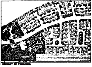
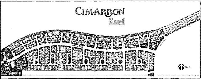
 The Cimarron development is situated on a narrow 38-acre plot of land which Rnoell Homes had originally laid out for 149 detached single-family units. After joining the. Demonstration Program, Rnoell redesigned the _ development to add 106 units, bringing the total to 255.
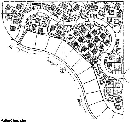
 The original plan for The Park called for the construction of 153 detached and attached units on a 21.9-acre site of approximately triangular shape. This initial plan was both innovative and efficient in terms of land use. _ However, when Phillips Homes joined the Affordable Housing Program, the site was redesigned to increase the number of units to 176, increasing density from 7 to 8 units per acre.


 North Meadow Village occupies a triangular 6-acre site. Density is 9.7 units per acre. Homes in the development are arranged in pinwheel clusters.

 Innovare Park is constructed on a panhandle-shaped 7.98-acre site. The original site plan was for 34 detached units in a traditional grid pattern with straight-run streets. After joining the Affordable Housing Program, Hood Enterprises redesigned the site to accommodate 86 detached units.
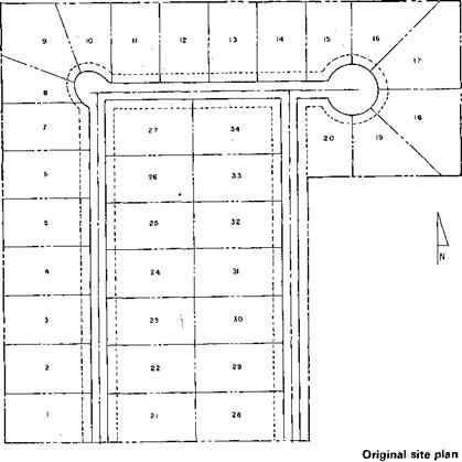
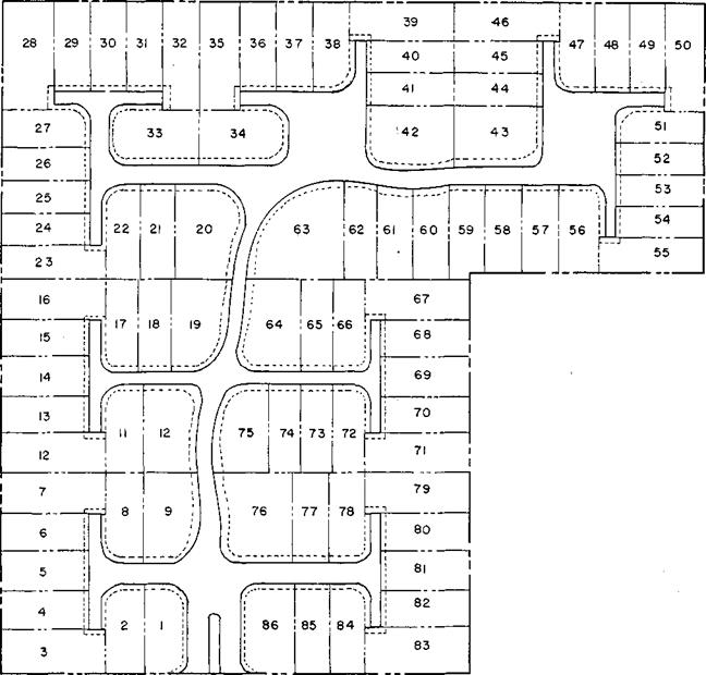


 Traditional housing development plans prevalent in the Post-World War II oeriod are characterized by a grid oattern of wide streets with houses on ‘arge lots with large setbacks.
 There are a number of ways in which well-planned higher density can contribute to, rather than detract from, beauty and liveability. For example, a greater amount of common open space and more possibilities for preservation of attractive natural features of the site are often easier rather than more difficult to incorporate into good plans for higher – density occupancy.


 The traditional practice of using large setbacks from all four boundaries of the lot reduces the usability of land on both sides of the house, particularly on smaller lots. By placing the house directly on the lot line on one side, usable land on the other side is doubled.

 As net density increases, lot sizes become smaller and land needed for roads per housing unit decreases.
 increased density. Developers reported their biggest cost savings resulted from lower land and infrastructure improvement costs per unit due to the higher densities achieved by small lot development. Higher density allows land and improvement costs to be spread over a larger number of units. Reduced frontage and front yard setbacks allow for less pavement and sidewalk per unit, shorter utility runs, and reduced material costs. Wide streets and rights-of-way, although sometimes functionally justifiable, add to land development and, ultimately, housing costs.
 Most of the projects in the Affordable Housing Program received some form of fast-tracking processing. In many instances, the city used the program as a test for the improvement and expediting of procedures, and successful innovations were frequently adopted for general use.


 A Task Force, comprised of seven industry representatives and thirteen department heads working with Chairman Ray Greene, streamlined the Tulsa plan review and construction permitting process from a long process involving nine separate authorizing departments, to a one-stop system completed in days. Additionally, sequential inspections were replaced by concurrent inspections. Local architect J. L. Richardson commented, "This is the first time the Tulsa government and the private sector have gotten together to resolve mutual concerns. The city knows developers prefer to do business in areas with minimal red tape."
 Interdepartmental Coordination for Complex Projects
 The New Mexico state inspector cooperated with Walton Chapman Builders by providing daily inspections of Fairway Village without being called. Each morning the inspector stopped at the project at the beginning of his daily rounds to inspect whatever was ready on that day. The City of Santa Fe rejected Chapman’s request for concurrent rather than sequential processing, but it made every effort to expedite its procedures.


 A majority of the projects in the Joint Venture for Affordable Housing (JVAH) were developed under some version of Planned Unit Development zoning or subdivision regulations.

 approach "provides a higher degree of regulation but permits the developer more flexibility in principal and accessory uses and of lot sizes than conventional zoning."
 Black Bull Enterprises, Inc., developer of the affordable housing project "North Meadow Village," sought and secured from the city a number of innovative zoning modifications for the land parcel of which North Meadow Village forms one part. The parcel is situated in an area zoned for low-density, single-family construction at four units per acre. Black Bull requested establishment of a multifamily zone (22 units per acre) around a shopping center in the 150-acre tract located on a two-lane state highway, and a medium-density singlefamily strip (6.28 units per acre) separating the low-density singlefamily zone from the multi-family zone. In effect, he asked the Planning Bureau to trade higher densities in one portion of the tract for lower water and sewer usage in the commercial and retail area, with no net change in total water and sewer demand. The rezoning was approved by the city.
 Under this city’s PUD, Holland Land Company was able to cluster homes, increase open spaces, and mix singlefamily detached units, duplexes,, and quadplexes in "Woodland Hills," a subdivision of HUD-code manufactured homes.


 The study should examine each of the three principal stages of the application process and make recommendations for improving procedures at each stage, as follows:
 City staff responsible for inspection must respond to builder and developer requests in a timely and scheduled manner. Developers and builders have a responsibility to assure that the work for which inspection is requested has been completed and meets the relevant criteria. Cities are justified in requiring that their time and expertise are efficiently used.
 Land use is regulated through zoning and subdivision ordinances. In general, zoning ordinances create the broad outlines of such regulation, while more detailed matters are dealt with through subdivision ordinances. Exceptions to zoning ordinances usually require substantial formal procedures, including a public hearing process. By contrast, variances in
 Land values are a central component of housing cost. The relationship of zoning to land value and to housing cost is direct. A recent Urban Land Institute study of the relationship between zoning restrictions and average lot prices showed that in the ten cities rated most restrictive by the Institute in their zoning requirements, the average lot price in 1980 was $24,037. In the ten cities rated least restrictive, the average lot price in 1980 was $14,688.
 PLAY ■ FIELDS
 In the late 1950s and 1960s home builders and public officials began to use an approach to zoning and subdivision regulation called Planned Unit Development (PUD), also called Planned Residential Development (PRD), Comprehensive Residential Development (CRD), or Community Unit Plan (CUP). Projects developed under this concept usually incorporate a variety of housing types and land uses, higher density, and open space and common land managed by a community association.