Category Water Engineering in Ancient Civilizations. 5,000 Years of History

The aqueducts of the city of Rome at the end of the 1st century AD

The accession of Nero to supreme power marked the beginning of a somber period for Rome.[228] Civil war followed his assassination in 68 AD, then came the too-short reigns of Vespasianus and Titus. After a promising start, Domitian becomes morbidly suspi­cious, and sheds the blood of those near to him and his collaborators only to end up being assassinated himself in 96 AD. Then Nerva, an old senator, is chosen as the new emper­or in a climate of restoration of the old Roman virtues. We have noted earlier that the Romans placed high symbolic value on water; among the early preoccupations of the new emperor is the restoration of water distribution in the city. For this he calls on a for­mer collaborator and experienced administrator: Sextus Julius Frontinus, 61 years old, former governor of Britain, i. e. Great Britain, and former preconsul of Asia. In 97 Nerva names Frontinus as curator aquarum, translated as “high commissioner for water” of the city of Rome. Frontinus is a methodical man who takes his responsibili­ties seriously. At the beginning of his service, Frontinus prepares a written description of the aqueducts of the city for his own information and then continues with written descriptions of his observations, measurements, and actions during his tenure. This trea­tise has come down to us, and we have already cited several extracts. We can learn much about both the characteristics and the history of these aqueducts from Frontinus’ writings (Table 6.2).

The principal aqueducts at the time of Frontinus came from the region of the Sabine mountains; the four largest ones, Anio Vetus, Marcia, Claudia and Anio Novus, came from the valley of the Anio, upstream of Tivoli (the Roman Tibur) (see Figure 6.8). Where this river flows out onto the plain of Rome, at Tivoli, the aqueducts leave the val­ley of the Anio and trace a large arc in the direction of the Alban mountains, thus main­taining their elevation as they near the city of Rome. On the Frascati heights, they are rejoined by the Tepula and Julia aqueducts, and complete their trajectory to the city on arches. At their entrance into Rome, the Anio Novus flows above the Claudia, on the same arches (Figure 6.9). Similarly, the canal of the Julia is above those of the Tepula and the Marcia, all three superposed on the same arches. These five aqueducts flow on a slope of about 1.3 m/km in their final reaches.[229]

What surely motivated Nerva to put things in order was that the amount of legally distributed water was far less what it was expected to be, as dictated by the written impe­rial records. The new curator aquaraum therefore took it upon himself to make dis­charge measurements in the aqueducts, both at their origins and at their points of arrival in the city. To his surprise, he found that now the measured discharges were well above those specified in the official registers. There could only be one conclusion: there had been fraud, greater fraud than had originally been suspected!

Here we must pause to note the significance of discharge for the Romans. Not hav­ing understood or recognized the physical concept of water velocity, the Romans found it sufficient to measure the flow cross-section at spots where the water velocity was

Table 6.2 The nine aqueducts of Rome in the days of Frontinus (about 100 AD)[230] Two other aqueducts, the Trajana and the Alexandrina, are constructed later. The indicated discharges are estimated from the equivalence: 1 quinariae = 40.6 m3 per day. The total discharge (all but Alsietina) is 977,00 m3/day.

Name

Construction

Date

Length (km) and % under­ground

Avg

Slope

(m/km)

Discharge (i. e. Area) (quinariae)

Estimated

Discharge

(m3/day)

Origin and quality of water

Appia

312 BC

16.5

(95%)

0.6

1,825

73,000

Spring in the Anio valley. Excellent

Anio Vetus

272 BC

64

(99%)

3.6

4,398

175,900

Anio River.

Somewhat

muddy

Marcia

144 BC

91

(88%)

2.7

4,690

187,600

Captured from springs Excellent

Tepula

125 BC

18

(46%)

5

445

17,800

Captured from ground­water.

Warm water

Julia

33 BC

22

(54%)

12.4

1,206

48,200

Springs.

Excellent

Virgo

19 BC

21

(92%)

0.2

2,504

100,200

Springs.

Excellent

Alsietina

2 AD

33

(99%)

6

392

15,700

Lake

Alsietinus nonpotable (used for water games)

Claudia

47 AD

69

(78%)

3.8

4,607

184,300

Springs.

Excellent

Anio Novus

52 AD

87

(84%)

3.8

4,738

189,500

Anio River. Muddy

judged to be neither excessive nor too weak. The Roman unit of discharge, the quinar – ia, is actually just a measure of area (4.2 cm2), whereas everyone knows today that vol­umetric discharge is the product of the velocity and the cross-sectional area of the canal. What Frontinus really measured is the depth of water in well-defined locations in the canal, from which he deduces the area and therefore calculates his estimate of discharge in quinariae. The discharges shown in table 6.2 are based on a fixed relation between quinariae and real discharges. We will discuss this further at the end of this chapter, regarding the hydraulic knowledge of the Romans. As imprecise as it was, this system nevertheless enabled Frontinus to detect the important deficits and differences described above:

“I do not doubt that many will be surprised that according to our gaugings, the quantity of water was found to be much greater than that given in the imperial records. The reason for this is to be found in the blunders of those who carelessly computed each of these waters at the outset. Moreover, I am prevented from believing that it was from fear of droughts in the summer that they deviated so far from the truth, for the reason that I myself made my gaugings in the month of July, and found the above-recorded supply of each one remaining constant throughout the entire remainder of the summer. But whatever the reason may be, it has any rate been discovered that 10,000 quinariae were intercepted, while the amounts granted by the sovereign are limited to the quantities set down in the records.

“Another variance consists in this, that one measure is used at the intake, another, consid­erably smaller, at the settling-reservoir, and the smallest at the point of distribution. The cause of this is the dishonesty of the water-men, whom we have detected diverting water from the public conduits for private use. But a large number of landed proprietors also, past whose fields the aqueducts run, tap the conduits; whence it comes that the public water­courses are actually brought to a standstill by private citizens, just to water their gar­dens.”[231]

This observation is rather severe. Numerous wildcat taps provide a clandestine water supply to those living adjacent to the aqueducts, and support a parallel, unofficial water market. Nearly half of the water delivered to Rome by the aqueducts escapes the official accounting. But what also upsets Frontinus is that water from the different aque­ducts is senselessly mixed together without taking into account the quality of the differ­ent sources. The last aqueduct built under Claudius, (predecessor of Nero), the Anio Novus, serves to complete the aqueduct system, and its additional supply was useful in obscuring the pilfering:

“The two Anios (aqueducts) are less limpid, for they are drawn from a river, and are often muddy even in good weather, because the Anio, although flowing from a lake whose waters are very pure, is nevertheless made turbid by carrying away portions of its loose crumbling banks, before it enters the conduits (….)

“One of the Anio (aqueducts), namely Old Anio (Anio Vetus), running at a lower level than most of the others, keeps this pollution to itself. But New Anio (Anio Novus) contaminated all the others, because, coming from a higher altitude and flowing very abundantly, it helps to make up the shortage of the others; but by the unskillfulness of the water-men, who divert­ed into the other conduits oftener than there was any need of an augmented supply, it spoiled also the waters of those aqueducts that had a plentiful supply, especially Claudia, which, after flowing in its own conduit for many milles, finally at Rome, as a result of its mixture with Anio, lost till recently its own qualities. And so far was New Anio from being an advan­tage to the waters it supplemented that many of these were then called upon improperly through the heedlessness of those who allotted the waters. We have found even Marcia, so

charming in its brilliancy and coldness, serving baths, fullers, and even purposes too vile to „75

mention.

The aqueducts of the city of Rome at the end of the 1st century AD

Figure 6.8 Layout of the aqueducts of Rome. This map also shows the Trajana and the Alexandrina, built after the magistracy of Frontinus. See Figure 6.36 for the imperial ports. Adjacent: elevations of the aqueducts at their points of arrival in Rome. The Aqua Marcia is shown on a Roman coin (author’s collection).

Frontinus devotes the three years of his mission to reducing these clandestine diver­sions, and improving the distribution system, both quantitatively and qualitatively. He restores respect for the quality of consumable water, and moves the intake of the Anio Novus further upstream to capture clearer water. He also improves the reliability of sup­ply to the public fountains, supplying each with two outlets so as to assure continuous supply when work is being done on one of the aqueducts.

25 Ibid., 90-91.

The aqueducts of the city of Rome at the end of the 1st century AD

Подпись: Figure 6.10 Evolution of discharge delivered into Rome by the aqueducts, compared with the evolution of the city's population.26 The vertical error bars reflect uncertainty in present-day estimates of the city's population.

Figure 6.9 The Agua Claudia and the Aqua Anio Novus on the same arches, at the Porta Maggiore of Rome. The aqueduct was integrated into the new city wall under the emperor Aurelius, in the 4th century AD (photo by the author).

26 The discharges are those of table 6.2, after Frontinus. The demographic data are taken from Christol andNauny (1997).

Whatever may have been these problems in managing the system, they did not reflect any fragility in the supply of water to the city. Figure 6.10 shows how the increase in discharge delivered to Rome accompanies the demographic growth. With nearly a cubic meter of water per person per day, a Roman inhabitant had nearly a hundred times more water than his or her counterpart in Paris of the 19th century!

Later, two additional aqueducts are constructed, but they are less well known to us since they came after the writings of Frontinus. They are the Trajana, constructed around 110 AD under the grand Emperor Trajan, successor of Nerva; and the Alexandrina, built under Alexander Severus in 226 AD. From the 2nd century AD, Rome falls into a kind of recession, and its population probably stabilizes. This second century is the century of the provinces, insofar as expansion is concerned. The construc­tion of grand aqueducts begins again in these provinces, in particular in Gaul, Spain, and Africa.

Evolution of aqueduct techniques

The Cretan, Greek, and later the Hellenistic aqueducts primarily use terra-cotta pipes. The Romans, following the Etruscan heritage, build their aqueducts as masonry canals, usual­ly rectangular in section, and covered over by a vault or stone slabs. The aqueducts are fit­ted with openings at regular intervals (from tens to hundreds of meters apart) to facilitate inspection and maintenance. We have seen earlier that the Aqua Appia, the first Roman aqueduct built in 312 BC, is nearly entirely underground. This practice is surely inherited from the Etruscan techniques, but also has a military dimension, since Italy is still far from being pacified at this time – this is only eleven years after the death of Alexander.

The Romans stay with this concept throughout the long period of aqueduct construc­tion in the Empire, i. e. from the 4th century BC to the 3rd century AD. A canal (specus) is, depending on the local topography, sometimes laid on the surface or on a supporting wall, or sometimes buried underground, occasionally passing through true tunnels, and, when necessary, supported on arched structures. The longitudinal profile of an aqueduct is driven by two constraints: first to maintain sufficient slope to convey the water, as regular as possible to avoid local break points; and second to deliver water at a high enough elevation to supply the city’s water tower (castellum) and thus enable distribu­tion of water to the highest areas of the city. Thus the arch structures that one often sees near the cities are needed to keep the canal at a sufficiently high elevation. And it is of course these arch structures, still visible today in numerous locations of the Roman Empire, that one commonly associates with the Roman aqueducts. However one should not forget that these structures represent only a small fraction of the total length of an aqueduct. The slopes of the canals are quite variable, as we will see in examples pre­sented further on, but most often are of the order of one meter per kilometer. Occasionally, where there is a need to drop to a lower elevation, there are local chutes comprising short sections of steep slope, or even true cascades.

Table 6.1 Characteristics of several known Roman aqueducts (after Hodge, 1995; Leveau, 1979; and other sources).

Location

City

Length

Average slope

Estimated

(km)

(m/km)

discharge

(m3/day)

Italy

Rome

11 aqueducts; see Table 6.2

1,127,220

Bologna

20

1.00

35,000

France

Lyon (Lugdunum)

4 aqueducts; see Table 6.3

Metz (Divodurum)

22

0.56

22,000

Nimes (Nemausus)[217] [218]

50

0.25

40,000

Arles (Arelate)

48

0.625

8,000

Strasbourg (Argentorate)

20

3.13

2,160

Germany

Treves (Augusta Treverorum)

13

0.6

25,450

Cologne (Colonia Agrippina)

95.4

3.89

27,000

Mayence (Mogontiacum)

28.6

Switzerland

Geneva

11

0.55

8,640

Neuchatel (Aventicum)

8

4.4

2,880

Spain

Segovia (Segovia)

15

16.4

1,728

Tarragona (Tarraco)

35

Toledo (Toletum)

50

England

Dorchester (Durnovaria)

15

5,200

Africa

Cherchell (Caesarea)11

40

2

38,000

Carthage (Cartago)[219] [220]

90.4 (Zaghouan) 118 (Djoukar)

2.9

17,280

Syria

1 3

Apamea-on-Orontes

150

1.3

Turkey

Pergamon (Pergamum)[221]

50

0.3

20,000

Let’s once again listen to Vitruvius:

“Water is conducted in three ways, either in streams by means of channels built to convey it, in leaden pipes or in earthen (terra cotta) tubes (that is, according to the Greek process cited earlier), according to the following rules. If in channels, the structure must be as solid as pos­sible, and the bed of the channel must have a fall of not less than half a foot to a length of one hundred.[222] These channels are arched over at top, that the sun may strike on the water as lit­tle as possible.

“(….) If hills intervene between the city walls and the spring head, tunnels under ground must be made preserving the fall above assigned; if the ground cut through be sandstone or stone, the channel may be cut therein, but if the soil be earth or gravel, side walls must be built, and an arch turned over, and through this the water may be conducted.”[223]

A masonry canal is not inherently watertight. Therefore it is necessary to plaster the useful (or “wetted”) walls of the canal, both to minimize leakage and to protect the masonry walls themselves from infiltration damage. The Roman plaster (opus signinum) is of very high quality. It is a mortar of crushed tile solidified with thick lime, also con­taining crushed brick and pottery shards, and sometimes other additives.[224]

The most imposing and important structures are those necessary to carry the aque­ducts across valleys. These are the famous bridge-aqueducts such as the Pont du Gard near Nimes (47.8 m high), or the bridges of Segovia and Tarragona in Spain or, similar­ly, the bridge of Chabet Ilelouine on the Cherchell aqueduct in Algeria, all three some thirty meters high. There are also the inverted siphons echoing the technology of the Hellenistic world. These expensive siphons are reserved for valleys more than 50 m deep, a depth beyond which the cost of a bridge becomes prohibitive. Further on we describe the siphons of Lyon, the largest ones in the Roman world, but it is first useful to provide a glimpse of this Roman technology.

Roman inverted siphons begin with a head tank, receiving water from the aqueduct’s canal, then distributing the water into one or more parallel lead pipes leading out of the basin. These pipes descend to the bottom of the valley and cross it on a bridge-siphon, and then come back up on the other side to an exit, or escape, basin. This exit basin then delivers water into the continuation of the aqueduct (Figure 6.7). Vitruvius emphasizes the need to provide a rather long and rectilinear length of siphon at the low point of the valley (the “venter”):

“(…) when it arrives at the bottom, let it be carried level by means of a low substruction as great a distance as possible; this is the part called the venter, by the Greeks coelia. When it arrives at the opposite acclivity, the water therein being but slightly swelled on account of the length of the venter, it may be directed upwards.

“If the venter were not made use of in valleys, nor the level substruction, but instead of that the aqueduct were brought to an elbow, the water would burst and destroy the joints of the

pipes. Over the venter long stand pipes (collivaria) should be placed, by means of which, the

violence of the air may escape. Thus, those who have to conduct water through leaden pipes,

may by these rules, excellently regulate its descent, its circuit, the venter, and the compres – 1 8

sion of the air.”

One can appreciate the value of a rectilinear “venter” (usually implemented as a bridge-siphon) in reducing the hydrodynamic force that would be concentrated on a small-radius elbow at the valley floor. But the reasons given by Vitruvius (i. e. to avoid the excessive “swelling” of the water) somewhat miss the mark. There has been consid­erable questioning of what is meant by the colliviaria. Some have interpreted them as purges to eliminate air. According to Henning Fahlbusch,[225] [226] [227] they are towers supporting an elevated intermediate reservoir, acting like a modern surge tank to purge air from the siphon’s “venter”. Such towers are useful when, in an inverted siphon, there are elbows or high points favorable to the formation of air pockets. The Tourillon de Craponne, on one of the aqueducts of Lyon that we describe further on, could serve as an example. Possible remains of others can be found at Aspendos, in the south of Anatolia.

Evolution of aqueduct techniques

Figure 6.7 The types of works found on Roman aqueducts: bridge, arches, tunnel, inverted siphon

Table 6.1 presents a synthesis of data for a number of known aqueducts in the Roman Empire. It shows that the aqueducts could reach quite significant lengths, often up to 50 or 100 km. But the length of an aqueduct is not, by itself, a good indicator of its grandeur. The construction of bridges, arcades, tunnels, etc. in effect reduces the length of an aqueduct, limiting the numerous detours that would be necessary if the structure had to follow the local topography along the ground surface. Certain aqueducts are actu­ally shortened during renovation, thanks to the construction of such projects. This is notably the case for the Aqua Marcia, one of the aqueducts of Rome:

“But now, whenever a conduit has succumbed to old age, it is the practice to carry it in cer­tain parts on substructures or on arches, in order to save length, abandoning the subterranean 20

loops in the valleys.”

The great aqueducts of Roman cities

Water is at the very top of the scale of values of Roman civilization. Water “not only services and satisfies the needs of the public, but also satisfies their pleasures.”[213] Numerous public fountains flow constantly in the city of Rome. Some individual users are granted a special concession for drawing water. Under the Republic this service is paid for, and it later becomes a free service granted by the Emperor. But the thermal baths, becoming widespread from the period of Augustus, are the most important water users.

The great aqueducts of Roman cities

Figure 6.2 A Roman public fountain at Ostia (photo by the author)

When water is in short supply, basic needs (e. g. public fountains, and flushing of sewers to maintain hygiene) must take priority over pleasure use. The architect Vitruvius describes a design giving priority to the public fountains (see Figure 6.4):

When they (the channels) are brought home to the walls of the city a reservoir (castellum) is built, with a triple cistern attached to it to receive the water. In the reservoir are three cisterns of equal sizes, and so connected that when the water overflows on either side, it is discharged into the middle cistern, in which are placed pipes for the supply of the public fountains; in the second those for the supply of the baths, thus affording a yearly revenue to the people; in the third, those for the supply of private houses. This is to be so managed that the water for pub­lic use may never be deficient.”[214]

There remain only a few traces of the Roman distribution networks, one of the few being at Pompeii (Figure 6.3) whose castellum corresponds rather well to the scheme described by Vitruvius.[215]

The great aqueducts of Roman cities

Figure 6.3 Water in a Roman city, Pompeii. The Figure shows the map of public fountains, the layout of water supply to public monuments and the intermediate works in the various circuits: elevated reservoirs and distribution towers. The distribution towers are fitted with a small elevated reservoir, whose level makes it possible to adjust the pressure in the downstream installations. The castellum of the Vesuvius gate (Figure 6.4) is situated at the highest point of the city, receiving its water from the aqueduct of Serino (Escheback, 1979-1983). In August 79 AD Pompeii is destroyed by an eruption of Vesuvius.

water passes over barriers of different elevations:

^ fine grid щґ f\

3

Y:icoarse grid/v-;<

1

Подпись: end point of the aqueduct: canal 1.3 m deep and 0.55 m wide

Figure 6.4 Castellum schematic at the Vesuvius gate of Pompeii, terminal point of the aqueduct, feeding the three distribution circuits. Water to these three circuits is supplied by overflow weirs at different levels, thus providing for a distribution hierarchy as recommended by Vitruvius.

The great aqueducts of Roman cities

Figure 6.5 A drainage inlet at Ostia (photo by the author).


The great aqueducts of Roman cities

The great aqueducts of Roman citiesFigure 6.6 The Anio Novus, one of the greatest Roman aqueducts, supported by arches in the Anio valley, between Tivoli and Castel madama. The canal, still lined with opus signinum, is well conserved. This aqueduct was built in 52 AD near the end of the reign of emperor Claudius (who also was responsible for the Aqua Claudia aqueduct), and is some 87 km long. It carries water captured from the Anio river, in the Sabine mountains near Subiaco.
(photo by the author).

As we can see through these examples, Roman cities benefit from an abundance of water, a bounty unequalled until the 20th century AD. Creation of this abundance requires that water be brought to the cities from springs or other supply points, where in general a storage reservoir is built, serving also as a settling or clarifying basin. The water is conveyed by aqueducts to the city’s castellum, or water tower, from which emanate the local distribution circuits. The aqueducts are often lasting monuments in which the Romans take great pride. A highly placed Roman official, whom we introduce later on, even compares these aqueducts to the Pyramids and to Greek temples:

“With such an array of indispensable structures carrying so many waters, compare, if you will, the idle Pyramids or the useless, though famous, works of the Greeks!”[216]

The Alexandrian heritage

Carthage is defeated in 202 BC, at the end of the Punic wars. This leaves Rome with­out a rival in the western Mediterranean, so she immediately begins her expansion toward Greece and the Orient. This evolution is inexorable, despite some temporary set­backs due to resistance such as that of the king of the Pontus, Mithridate Eupator (in whose land the remains of one of the first water mills has been found, as noted in the preceding chapter). The annexation of Egypt by Augustus in 31 BC effectively ends the Roman expansion toward Asia. After the occupation of the coast of North Africa at the end of the 1st century AD, the Mediterranean becomes the mare nostrum, a sea that is entirely bordered by Roman lands.

One can clearly see the appearance of the Alexandrian heritage in Roman techniques during the Augustin period. The monumental work On Architecture of Marcus Vitruvius Pollio, who lived in the 1st century BC under Julius Caesar and Augustus, paints a vast tableau of techniques for the information of the new emperor. This broad-brush panora­ma integrates the skills of the Alexandrian School from the 3rd century BC. It describes the siphon, whose use, when implemented with Roman know-how, had already made it possible for water from the Aqua Marcia aqueduct to reach Capitol and Palatain (in 144 BC). It also describes use of the Ctesibios pump, lifting water wheels, etc. During the four centuries of prosperity of the Empire – until its economic decline of the 3rd centu­ry AD and the fall of the western Roman Empire in 410 AD – indelible symbols of the power of Rome were left in the development of water supply, water use in the cities, agricultural productivity in the provinces, and the development of maritime commerce. Many of the countless hydraulic structures and installations that were constructed remain with us today as symbols of that power.

Hydraulics in the Roman empire: Driving Force of development and symbol of civilization

The Etruscan hydraulic heritage and the beginnings of Rome

Civilization does not truly begin to develop in the western Mediterranean until the begin­ning of the 8th century BC. This begins according to the legend when the Phoenicians, led by Elissa, princess of Tyr, found Carthage on the Tunisian coast. Then the Greeks establish colonies in Sicily and in the south of the Italian peninsula in the middle of the 8th century BC. These colonies become a cultural ensemble called Greater Greece. But the capital event for Italy during this same period is the arrival of yet another people who settle to the north of the Tiber. According to Herodotus, these new arrivals came from Anatolia. In response to an extended period of famine, the king of the Lydians has his son Tyrrhenios lead half of his people out of their homeland. They take to the sea, trav­eling westward to Tuscany and Umbria where they become a new people: The

Etruscans – or the Tyrrhenians as they are called by the Greeks. In the 6th century BC they spread onto the plain of the river Po, and to the south as far as Campania. Their beautiful urban civilization profoundly marks the Italian countryside; the cities have their own water supply, the streets are straight and aligned at right angles, with gutters and extended underground sewage networks, following the Aegean and Oriental tradi­tions. The Etruscan economic miracle rests on three pillars: the mastery of commerce, the exploitation of iron mines, and the development of land for agriculture.

The principal obstacle to development of Etruria is the accumulation of water in the numerous marshy depressions of the valleys. During the entire period from the 7th to the 4th century BC, the Etruscans drain large regions of Italy by means of dense net­works of underground drainage galleries, called cuniculi.1 These galleries, from 300 m to several kilometers in length, are about 1.5 m high and 0.5 m wide. They normally fol­low the courses of the valleys they drain, aligned slightly off the valley centerline (and usually to the right) at a depth of some 30 meters. Vertical shafts are regularly spaced at 30 to 35 m, extending from the galleries up to the surface. These shafts facilitate the ini­tial digging of the drainage galleries, and then provide aeration. These cuniculi follow the valley down to its mouth, or sometimes pass under a ridge to connect to a neighbor­ing valley.

This preoccupation with land drainage is accompanied by a need to control the sup­ply to, and level of, the many lakes of Etruria. Underground drainage works are built in the lakes of Burano, Nemi (near Rome), and Albano. Lake Albano has a 1.5 m wide tun­nel that varies in height from 2 to 3 m. It is 1,200 m long, and passes underneath the present city of Castel Gandolfo. There are also artificial reservoirs, excavated and then sealed through paving with a mixture of clay and chalk. These reservoirs are used in the [208] wet season to store water, and in the dry season to supply water for crops through terra­cotta pipelines.[209]

In their conception and construction of underground conduits, the Etruscans show a marvelous mastery and skill in hydraulic works. They are also good miners. Their know-how in both areas could well have been developed locally, but they surely brought much of their expertise in hydraulics from the Orient. It is interesting to note certain similarities between the Etruscan cuniculi and the qanat, broadly spread within the Persian Empire for water supply (see Chapter 2, Figure 2.19). Recall too that the Mycenaeans used natural grottos to drain marshy depressions (see Chapter 4, in partic­ular Figure 4.10).

The Etruscans are not only miners and peasants, but also sailors: they give their name to the Tyrrhenian Sea. In the 6th century BC, they share maritime domination of the western Mediterranean with the Carthagenians. Their united forces defeat the Phoenicians of Massilia (Marseilles) at the naval battle of Aleria (in Corsica), in about 535 BC. Maritime commerce flourishes, and numerous ports are developed. But in 474 BC, the Syracuse fleet defeats the Etruscans, pushing their maritime commerce back toward the Adriatic. The large port of Spina on the Adriatic is built on a lagoon that is connected to the sea, some 3 km distant, by a 30-m wide canal. It is likely that this port resembled modern Venice, with its canals connecting to the sea and to the nearby estu­ary of the Po.[210]

Simple huts occupy the site of the seven hills of Rome From the 8th century BC, around the marshy depression where the forum will later be built. This site, at the south­ern boundary of Etruria, is easily fortified, and the Tiber River, navigable by small boats, adds to the attractiveness of the site. It is here that one finds the first ford of the Tiber, and soon the first bridge, that of Sublicius. In 575 BC, a city is founded here by Tarquin (Tarquin the Elder), a rich Etruscan.

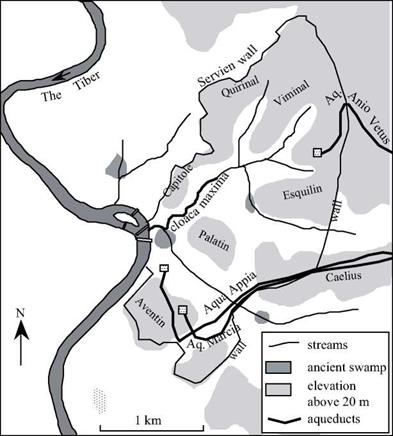
Quite logically, the first hydraulic project in the city is a drainage canal (Figure 6.1). Tarquin the Elder constructed the cloaca maxima to drain the depression of the forum and reclaim its land. At the end of the 6th century BC, Tarquin the Superb, third and last of the Etruscan kings of Rome, had the cloaca Maxima covered over since its physical presence had become an obstacle to further development of the city. With this, the canal began to also serve as a sewer. It had been generously dimensioned by its initial builders, and was not further modified until the 1st century BC under Augustus. Pliny the Elder left us a few words describing this work:

“(…) there are seven rivers, made, by artificial channels, to flow beneath the city. Rushing onward, like so many impetuous torrents, they are compelled to carry off and sweep away all the sewerage; and swollen as they are by the vast accession of the pluvial waters, they rever­berate against the sides and bottom of their channels. Occasionally, too, the Tiber, overflow­ing, is thrown backward in its course, and discharges itself by these outlets: obstinate is the contest that ensues within between the meeting tides, but so firm and solid is the masonry, that it is enabled to offer an effectual resistance.”[211]

Hydraulics in the Roman empire: Driving Force of development and symbol of civilization

Figure 6.1 The city of Rome under the Republic, the cloaca maxima, and the arrival into the city of the first aqueducts. The Aqua Applia passes underneath the Aventin. The Marcia, carried on arches in the countryside, is at a higher elevation, and arrives at Aventin through the siphon of Caelius.

Rome became a republic in about 509 BC, Tarquin having been run out. After the incursion of the Gaels into Italy, about 390 BC, Rome becomes the main power of cen­tral Italy. The Aqua Appia, first of the Roman aqueducts, is built in 312 BC. Its dimen­sions are similar to those of the Etruscan cuniculi (0.69 m by 1.69 m), and almost all of it is buried:

“For 441 years after the founding of Rome, the Romans made do with water that they drew from the Tiber, from wells, or springs. The memory of the springs is still a fond one today. (….) Under the consulship of M. Valerius Maximus and of Pl. Decius Mus, thirty years after the start of the Samnite war, the Aqua Appia was brought into the city by the censor Appius Claudius Crassus, later known as Caecus (The Blind). He is the one who also established the Appian Way from the Capene Gate to the city of Capua. (….). The Appia is fed from a loca­tion in a domain of Lucullus, on the Praenestina road, between the seventh and eighth milles. (…). From the saline spring, a named place near the Porta Trigemina, the conduit has a length of 11,190 paces, of which 11,130 are an underground canal, and, above ground, on support­ing walls and arcades, 60 paces near the Capene Gate.”[212]

Who burned the Library of Alexandria?

The legend that attributes the arson of the Library of Alexandria to Julius Caesar is ques­tioned today. We have seen clearly, to the contrary, that the intellectual movement of Alexandria knew a second fruitful period under the Roman Empire. In this period, it is a procurator supra museum et ad Alexandrina Biblioteca, named by the Roman prefect, who administers the Museum and the Library.[204] [205] It is generally accepted that the period of greatest creativity at the institution was in the 2nd century of our era.

However, we should remember that it is only a short time before the capture of the city by the Arabs, in 642, that one finds Jean Philopon’s most virulent critique of the Physics of Aristotle. Thus to the extent that periods of intellectual decadence are reflect­ed in the absence of a critical view of the treatises of the ”ancient greats”, Alexandria remained a great intellectual center to the very end.

But in a world that insists on rushing toward a precipice, important discoveries and ideas are destined for oblivion. The legendary burning of the Library is a symbol of this headlong rush: did the books merely burn, or was it the intellectual drought of troubled times that prevented the survival of the theories of Heron, Jean Philopon, and so many others?[206] There certainly were episodes of book destruction during the period of the last centuries of Roman domination, either as acts of war, or as the ravages of religious fanaticism. In 290 AD, during the re-taking of Alexandria after it had been conquered by Zenobia, queen of Palymyra, an entire section of the city is set aflame. In 391, the bishop Theophilos intentionally destroys the library of Serapeion. And in 640, after the taking of Alexandria by the Arabs, the remaining 54,000 books are burned as fuel for the public baths, on the order of the caliph Omar. According to the tradition reported by Arab historians, Jean Philopon tried in vain to persuade the conquerors to spare the

books.[207]

Galien of Pergamon and the beginnings of biomechanics

There is another branch of fluid mechanics that sees some early development in this peri­od: this is the knowledge of blood circulation. Whereas it was believed that the arteries contained only air prior to this period, Galien of Pergamon (129 – 200? AD)[202] is the first to describe arterial circulation and to study seriously the circulation of blood in the heart. For this he relies on an intense practice of dissection.[203] His only error is in believing that the blood passes directly from the right ventricle to the left ventricle.

The first discovery of the resistance to motion through the air

We mentioned in Chapter 4 the dominant theory of Aristotelian Greek science on the movement of objects in air. This theory held that air actually entrains the movement of a body (a thrown spear or an arrow) rather than slowing down this movement. In this theory, the air displaced by the front of the projectile comes back to the rear and pushes the object in its flight. Jean Philopon of Alexandria (in the 6th or beginning of the 7th century BC), in his Critique of the Physics of Aristotle, strongly rejects this theory:

”How could it be that the air, pushed by the arrow, does not move in the direction of the impulse that has been given to it, but instead does an about-face, as if ordered to do so, and backtracks? Moreover, how could it be that this air, in this about-face, does not disperse into space, but instead returns to strike precisely the notched end of the arrow, continuing to push it and stick to it? Such a conception totally lacks plausibility, and smacks of fiction. z

Later in the same work, Jean Philopon suggests that it is indeed the thrower who “provides the motive force for the rock” (which is what will later be called the kinetic energy or momentum). He also says that “if one imparts an unnatural movement, or a forced motion, upon an arrow or a stone, the same degree of motion will be attained more easily in a vacuum.” Continuing his discourse through the description of experi­ments with falling bodies, Jean Philopon observes that the time of fall depends very lit­tle on the weight. He shows finally that the air does indeed exert a resistance to the advancement of the body in motion.

Heron of Alexandria and the first expression of the volumetric discharge of a canal

Before Heron, no correct notion of the discharge of a canal, pipe, or river had been cor­rectly formulated. Indeed, the notion of velocity was essentially unknown in Greek mechanics. The quantity of water delivered by an aqueduct or canal was quantified uniquely by a measure of the flow area. It was Heron who formulated for the first time the notion that the volumetric discharge, i. e. the volume of water delivered in a unit of time, is the product of the flow area and the velocity. One finds the following in his work Dioptra:

“It is to be noted that in order to know how much water the spring supplies it does not suffice to find the area of the cross section of the flow… It is necessary also to find the speed of the flow, as the swifter the flow is, the more water the spring supplies.”[201]

The importance of the current velocity in calculating the discharge is thus estab­lished, but Heron did not have any means of measuring this velocity. So he also pro­posed another means of calculating the quantity of water delivered in a day:

“One should therefore dig a reservoir below the stream and note with the help of a sundial how much water flows into the reservoir in a given time, and thus calculate how much will flow in a day. The amount of water will be clear from the measure of the time.”

Coming too late to be useful to the Romans, who were the great constructors of this period, the concept is destined to be gradually forgotten over time. It is only in the West during the Renaissance that it will once again be formulated.

The science of fluids at Alexandria under the Roman domination Heron of Alexandria and the “pneumatic” machines

The contributions of Heron of Alexandria belong for the most part to the continuum of work of Ctesibios and Philon of Byzantium. It was believed for quite some time that he lived in the 1st century BC. Now, Heron, in his work Dioptra, describes how to estimate the distance between Rome and Alexandria through observation of a lunar eclipse – an eclipse that took place in 62 AD.[198] The work of Heron therefore must be dated from the second half of the 1st century AD. The importance of this detail will appear in Chapter 6 in the context of understanding Roman treatises on aqueducts. Like Ctesibios and Philon, Heron is the author of a treatise on Pneumatics. Acknowledging his debt to earlier authors, but claiming some of his own originality, he describes a number of machines. These include the fire pump or pump of Ctesibios[199] (with a single modifica­tion compared to what is shown in Figure 5.5: the intermediate reservoir C is deleted), and automatic devices that “solicit astonishment and admiration”, and therefore are essentially toys (today we would call them “gadgets”).

The principle of these automatic devices is based on the effects of pressure in fluid. Some of them use the siphon and connected chambers, as mechanisms for the automat­ic filling of a vase, mixing of two liquids, etc. Other devices are powered by the effects of gaseous expansion: the most remarkable invention is surely “Heron’s steam ball” (Figure 5.14), or eolipile, a device in which water brought to a boil emits steam, the pres­sure of which turns a ball around an axis. This is the principle of a steam engine, noth­ing less! But the technology (or perhaps society?) was not up to the task of industrial exploitation of this invention. [200]

The science of fluids at Alexandria under the Roman domination Heron of Alexandria and the “pneumatic” machines

Figure 5.14 “Heron’s steam ball”, the principle of a steam engine. “Let the cauldron AB be placed over a flame, with water; its opening will be closed by the cover GD, through which passes the bent tube EZH, its end penetrating into the small hollow sphere QK; diametrically opposite the extremity H, one mounts the pivot LM, which rests on the cover GD. One adds to the sphere two small bent tubes, welded to the sphere, diametrically opposed to each other and bent in opposite directions; these elbows must be at right angles, and the tubes perpendicular to the line HL. The following occurs when the cauldron is heated: the steam passes into the tube EZH to go into the sphere, and it leaves by the small bent tubes in the wall, and causes the sphere to turn, like figures that dance.”38

The Nabatians of Petra, hydraulicians of the desert

Antigonus, the old one-eyed general of Alexandria, sought to solidify its domain in the Near East, between the domains of Ptolemy in Egypt and that of Seleucos in Mesopotamia. He coveted the wealth of the semi-nomad “barbarians” who frequented the routes of caravans carrying spices, myrrh, and incense from Maryab in Arabia Felix, to the south of the Dead Sea. In 312 BC, he sends his friend Athenes on an expedition toward the “formidable citadel”, the “rock” (petra in Greek) where these “barbarians” store their riches. Athenes does not come back alive. Antigonus then sends his son Demetrius to lay siege to Petra, again without success. Later, the Seleucids, new mas­ters of Syria, attempt the same exploit and also fail. These “barbarians”, objects of such envy for the successors of Alexander, call themselves the Nabatu. They likely came from central Arabia in the 5th century BC, and settled peacefully in the south of Palestine, left unpopulated by the deportation of the Assyrians and the Babylonians.

The Nabatian civilization becomes sort of a synthesis of the civilization of the ancient East and the new Hellenistic influences, since some degree of normal exchange continues during the wars with the Seleucids. Its golden age is at the very beginning of the Christian era before the Romans, new masters of Egypt, establish a direct maritime route toward the land of incense through Alexandria and the port of Myos Hormos on the Red Sea. In 106 AD, on the orders of Trajan, the kingdom of the Nabatians is peace­fully integrated with the Roman Empire, henceforth becoming the province of Arabia. The prosperity of the Nabatians is founded not only on the spice trade, but also on the technical prowess that enables them to farm the desert. This echoes the situation of the kingdom of Sheba, as we discussed in Chapter 3. Here, the main problem is to create arable land in the mineral wasteland of rocks and stones of the Negev desert. Weirs that partially block watercourses retain not only the annual floodwaters, but also and perhaps more importantly, they retain the silt conveyed by the floodwaters. This silt, accumulat­ed flood after flood, creates lands that eventually can be cultivated. This technique is surely inspired by earlier practices in Arabia Felix. But the reader may also recall the very ancient developments of Jawa and Khirbet el-Umbashi, in the Syrian-Jordanian desert (Figures 2.6 and 2.8). The technique will later be used by the Romans for the development of North Africa.

Under Nabatian control, the Negev becomes a land of immense orchards, farms, and villages, with roads, numerous water mills, and even cities like Oboda (today Advat) and Mampsis (Kurnub).

If Petra, the capital, is able to resist all attempts at conquest, it is because it is locat­ed on a site that is a natural fortress. The city is constructed in the valleys of the wadis, and served, thanks to the Nabatian techniques, by small dams. It is deeply entrenched in a tall sandstone massif, contoured by the combined actions of water and wind:

“The capital of the Nabatians is Petra; this is what it is called, for it is situated on a site that

■ wadis

deviation of the wadi Musa flood altitude above 950 m altitude above 1000 m (800) altitude in m A principal rock monuments

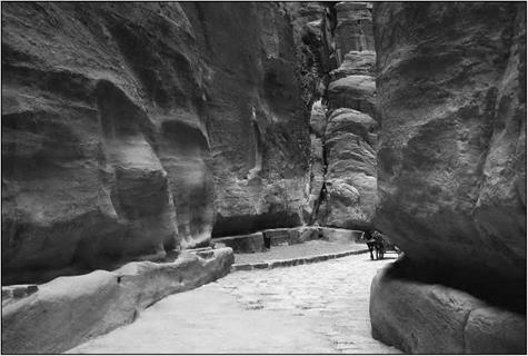
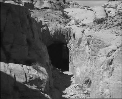
The site is accessible only through narrow gorges. The main route for access and communication, called Siq, is the gorge through which the Musa wadi, whose source is several kilometers to the east, penetrates the massif. This gorge is 1,500 m long, but only several meters wide (sometimes less than 3 m), and about a hundred meters deep. The wadi is usually dry, but the winter flood can be very sudden. To keep the Siq safely dry, once it had been transformed into a paved road, the Nabatians constructed a dam on the Musa wadi at its entry into the narrowest portion of the gorge. They also construct a tun­nel, 9 m high and 6 m wide and 88 m long, to redirect the flood waters toward the el – Mudhim wadi, then toward the el Metaha wadi, the flood waters rejoining their natural course at the city center (Figure 5.13).

This proj ect was very likely built at the beginning of the 1st century BC, at the same time as the planning for the urbanization of the city. The dam itself is 14 m high and 43 m long. The violence of the torrential rain, combined with the slope of the gullies and [196]
wadis (the bed of the Musa wadi, itself, has in the Siq a steep slope, around 40 m per kilometer), explains the rapidity of the floods. A recent hydrological study estimated that the maximum discharge of the Musa wadi flood must be about 200 m3/sec, reached in only one hour.[197] This dam was reconstructed in 1964, following the death of 24 tourists carried away by a sudden flood. Since then, the floodwaters have again drained through the Nabatian tunnel.

The city’s water supply is provided by aqueducts as well as by extended systems of dams, canals, reservoirs and cisterns collecting stormwater runoff. The first aqueduct was a channel which captured the spring water of the Musa wadi valley, and was built in the beginning of the 1 st century BC, then destroyed by a flash flood of the Musa wadi. It is rebuilt in the third quarter of the 1st century BC as a terracotta conduit following the right wall of the Siq, and complemented by the end of the 1st centuryAD by five other aqueducts, including a second aqueduct in the Siq (see photo fig5.13c), carved along the left wall of the Siq (Bellwald, 2006).

The Nabatians of Petra, hydraulicians of the desert

Figure 5.13b. The tunnel constructed by the Nabateans to redirect the flood waters of the Musa wadi towards the el-Mudhim wadi. The tunnel is, at its entrance, 9 m high and 6 m wide (photo by the author).

The Nabatians of Petra, hydraulicians of the desert

Figure 5.13 c. The Siq, which is the main access route to Petra, and which was the course of the Musa wadi before the dam and tunnel were constructed. On the right, the channel containing the terracotta aqueduct (dated by 25 BC), and on the left the channel of the other aqueduct constructed in the middle of the 1st century AD (photo by the author).