Category Water Engineering in Ancient Civilizations. 5,000 Years of History

More to the south: hydraulic works at the second cataract

The pharaohs of the middle Empire tried to develop fluvial commerce with Nubia while at the same time protecting themselves from Nubia. Sesostris III extends the border of Egypt up to Semna, beyond the second cataract. A stela contains the following text: “Southern border established in year 8 of his majesty the king Khakaoure (Sesostris III), so as to prevent any Nubian from crossing it, by land or boat, neither any Nubian herds; except Nubians who would come to do commerce in Iken (Mirgissa), but not to the point that any Nubian boat travels to the north beyond Heh (at the northern outlet of the pass of Semna), 17

ever.

The pass at Semna is fortified to enforce this proclamation, and to tightly control traffic on the Nile. The water surface is artificially raised and the Nile flumes are blocked, so that boats can pass only through the narrow passage between the two forts constructed on each bank.

At the second cataract, the site of Mirgissa is also fortified. A slideway is built for hauling boats around the natural obstacle formed by the cataract rapids. Boats enter this slideway from a harbor built in the calm upstream waters (Figure 3.5). The slideway, likely from the reign of Sesostris III (around 1870 BC)[102] [103] has a useful width of about two meters, and is sloped to facilitate the hauling. It is lined with wood and silt kept damp.

More to the south: hydraulic works at the second cataract

Figure 3.5 Hydraulic works at Mirgissa, at the second cataract (schematic reconstitution from Goyon, 1986; Vercoutter, 1991).

On the river to Nubia, navigation works on the Nile (IIIrd and IInd millennia BC)

Navigation canal at the first cataract

Nubia is rich in quarries, and in gold and amethyst mines. A concerted effort to exploit these resources of the south began in the VIIth Dynasty, under the ancient Empire. But the Aswan rapids, comprising the first cataract of the Nile (Figure 3.4), present an obsta­cle to navigation. In about 2400 BC the Pharaoh Merenre I has his close lieutenant Ouni build a flume system to allow boat passage through this obstacle. Ouni, who later becomes governor of Upper Egypt, had his autobiography engraved in his tomb, where one can read the following:

“Then His Majesty sent me to dig five canals (flumes?) in Upper Egypt and to construct three

barges and four transport boats, from acacia wood of the land of Ouaouat. The chiefs of the

lands of Ouaouat, Iam and Medla had the wood cut for this. I accomplished all of my task in

a single year. When the boats were launched, they were also loaded with big wide blocks of

1 3

granite for the pyramid (of Merenre)"

This account tells us the main reason for Ouni’s mission: the descent of boats com – [98]
ing from the stone quarries. The current in the flumes was surely too strong for upstream passage. The flumes were rebuilt, or enlarged, under the reign of the Pharaoh Sesostris III (XIIth Dynasty) in about 1870 BC, height of the middle Empire. But now the rea­sons were clearly military, since the work enabled Egyptian expeditions to travel upstream to the second cataract (in years 8, 12, 16 and 19 of the reign).[99] But clearly these flumes either were undersized or filled with sand, which would be no surprise given the strength of the currents in this area and therefore the sand load carried by the flow. New work was conducted under Thoutmosis I and Thoutmosis III, between 1490 and 1425 BC, this time including the construction of a true canal 10 m wide and 7 m deep.[100]

On the river to Nubia, navigation works on the Nile (IIIrd and IInd millennia BC)Herodotus did not travel upstream of the first cataract during his voyage in Egypt. Here is how the navigation conditions in this zone were described to him:

“From the city of Elephantine, going upcountry, the land is steep. There travelers must bind the boat on both sides, as one harnesses an ox, and so go on their way. If the rope were to break, the boat would be borne to its destruction by the strength of the current. This part of the country is four days’ journey by boat, and the Nile here is as twisting as the Maeander; there is a length of twelve schoeni to pass through in this fashion.”[101]

Strabo’s much later account of his trip up the Nile (by land route) beyond the cataract does not mention these works, indicating that the canal was no longer in serv­ice. It is not hard to imagine that it was quite difficult to permanently maintain such a project, without locks, in an area of strong currents.

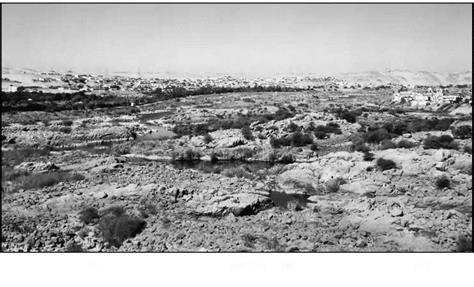
Figure 3.4 Rough terrain at the site of the first cataract, upstream of Aswan, at low water (photo by the author)

Sadd el Kafara11: the first known large dam… and the story of its failure

In the IIIrd or IVth dynasty, about 2700 or 2600 BC, The Egyptians undertook the con­struction of a dam on an ephemeral tributary of the Nile, the wadi Garawi, some ten kilo­meters southeast of Memphis. This effort, coinciding with the period of construction of the great pyramids of Giza, is part of the development and improvement of the region around the capital. The remains of the dam are still visible today on both banks of the wadi, and were studied in 1982 by a Germano-Egyptian team.[97]

The dam comprises two rock faces with central core of random material. The upstream and downstream faces are protected by cut blocks forming steps of about 30 cm in height (Figure 3.3). It is the length (113 m) and especially the height (14 m) of this structure that earn its recognition as the oldest known large dam. Even more sur­prising is the dam’s colossal thickness, nearly 100 m wide at the base and 66 m at the crest. This excessive thickness shows that dam techniques were still somewhat primi­tive in Egypt of the IIIrd millennium BC.

Sadd el Kafara11: the first known large dam... and the story of its failure

Figure 3.3 Remains of the Sadd el Kafara dam (about 2600 BC), on the right bank of the wadi Garawi. The oldest known large dam. View from upstream (photo of G. Garbrecht)

Sadd el Kafara11: the first known large dam... and the story of its failure

Figure 3.3a Cross section of the structure of the Sadd el Kafara dam on the wadi Garawi. The outside blocks form about 30 stairsteps. After Garbrecht (1985).

The most likely purpose of this dam was to protect downstream cultivated and inhabited areas riparian to the Nile from the violent floods of the wadi Garawi. Indeed, the structure’s permeable core argues against the hypothesis of a reservoir to store water for agricultural use. In any case, irrigation in Egypt at this period remains entirely based on floods of the Nile. Curiously, examination of the reservoir area shows no trace what­soever of sedimentation, suggesting that it was not the destiny of this important dam to survive very long.

We have already mentioned that the wadi Garawi is normally dry but can have vio­lent floods. Its bed slope is fairly steep at about 10 m per kilometer, and the flood dis­charge can be estimated at between 50 and 250 m3/sec. The storage capacity of the reservoir (620,000 m3) is insufficient to capture all the water of a large flood. On the left bank, there is a terrace whose elevation is 1.5 m below that of the dam crest. This terrace therefore can serve as a natural spillway, whether or not this was intended by the dam’s designers. The spillway has a capacity of the order of 85 m3/sec, beyond which flow the dam can be overtopped. Given its broad dimensions and rock protection, the dam should have been able to resist partial overtopping. These analyses led Gunther Garbecht to hypothesize that the dam failed before it was completely finished, when the upstream rock face had been built to its nominal height but neither the downstream face nor the filling of the core were completely finished. Submerged by an exceptional flood, the dam could have been ruined by erosion of the central core and collapse of the upstream face. This failure would surely have resulted in downstream destruction, and the memory of this catastrophe could explain the absence of new dam construction in Egypt for many centuries to come.

The earliest developments in Egypt, IIIrd millennium BC

One of the first depictions of an Egyptian king is found on a macehead,[92] where the king is apparently opening a breach in a dike with a hoe, next to a man who is filling a basket with dirt. This king, called the Scorpion King from the ideogram on the mace – head, is said to have lived around 3200 BC. This is the period during which writing first appeared in Egypt, and also a time of growing political unity between upper and lower Egypt.

Development of the capital Memphis

Herodotus visited Egypt in 460 BC when it was under Persian domination. He reports (on the basis of information from priests) that a king called Min (Menes) built the new capital of unified Egypt, called Memphis, at the border between the upper and lower
portions. The construction of large dikes consummated the establishment of this city:

“The Egyptian priests say that Min, who was the first king of Egypt, dammed off this place of Memphis from the Nile. For the whole river flowed close by the sandy mountain that is toward Libya, but Min, damming up the southern bend of it, about a hundred furlongs south of Memphis, dried up the ancient channel and channeled the river to flow through the middle of the mountains. Even to this day this bend of the Nile is most heedfully observed by the Persians, that it may flow in its confined course, and every year the barriers are built up again. For if the river should break out at this point, there would be a danger that all Memphis would go down in the flood. When Min, this first king, had made the cut-off part into dry land, he founded within it the city that is now called Memphis – for Memphis, too, lies in this narrow part of Egypt – and, outside it, he dug a lake away from the river to the north and west (for the Nile itself was the barrier toward the east), and he founded within the city the temple of

o

Hephaestus, which is indeed a great one and exceedingly worth telling of.” °

Who is this Min? He is very likely the first identifiable Pharaoh, Menes or Narmer, who probably reigned between 3150 and 3125 BC[93] [94]. The dike he constructed at Memphis has been the subject of some speculation. Considering the difficulty of block­ing a river like the Nile (and especially considering that this work would have been accomplished at the very beginning of the history of Egypt), it seems very unlikely that it was a true dam. Herodotus, who is considered to be a reliable witness, is careful to distinguish between what he sees and what he is told. He sees the dike, and he can see that it is maintained. It seems plausible that Memphis was founded by draining swampy land, perhaps in an abandoned branch of the Nile, and by then building the dike some twenty kilometers upstream to protect these drained lands from flooding. This dike had to be a dozen meters or so high, this being the height of the largest floods at Memphis.

The port of Memphis is without doubt the greatest in Egypt. It is thought to have been on the left bank, embedded in the valley of a wadi that flows along the edge of the plateau. The port is nearly a kilometer long and 200 to 300 m wide. It is connected to the Nile by a canal extending to the north along the edge of the plateau, providing access to the cultural and funereal sites of Saqqarah.[95] [96]

The Nilometers

One can readily see that in Egypt, measurement of the flood level has great importance. The management of the irrigation system is based on such measurements, as are the taxes, since the agricultural yield can be deduced almost automatically from the flood level. The level is quantified using graduated scales carved into stone; Strabo calls these [87] [88]

The Nilometers

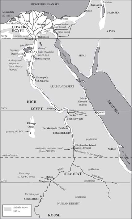
Figure 3.1 Major hydraulic works in ancient Egypt and Nubia.

scales “nilometers”. The most well-known nilometers[89] are those at the fortified pass of Semma, upstream of the second cataract (around 1800 BC), on Elephantine Island at Aswan, downstream of the first cataract (1800 BC), at the temple of Karnak at Thebes (800 BC), and near Memphis upstream of the delta (Figure 3.1). But much older nilome­ters surely existed, since flood levels were reported in the annals of the IVth and Vth dynasties (2500 – 2000 BC).[90] The unit of measurement is the nilometric cubit, or 0.525 m. The zero, or datum, of the nilometric scales is quite probably set at the low-flow level of the river, a level that can vary over time as the width of the river varies (a scale change occurred about 2000 BC). The scales have marks that correspond to favorable flood lev­els: a little more than 21 cubits at Elephantine, 12 to 14 cubits at Memphis, 7 cubits in the delta.

There are two particularly important locations for flood measurement: at

Elephantine (Aswan), the point of entry of the flood into Egypt proper, and at Memphis,

The Nilometers

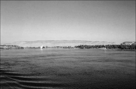
Figure 3.2 The Nile between Thebes and Aswan (photo by the author). One can see the contrast between the green irrigated plain (dark in the photo) and the arid hills in the background.

sentinel of the flood that will appear on the delta. In fact there are two nilometers at Aswan. According to tradition, a precise water level at Aswan is obtained in a well con­nected to the river, to dampen fluctuations caused by waves in the river itself. The date

of this concept is unknown. Let’s again listen to Strabo:

“The nilometer is a well, built of stone quarried from the banks of the Nile itself, in which there are marks indicating the greatest floods of the Nile, the smallest, and the average, for the water level in the wells rises and falls with that of the river. This is why there are marks on the walls of the wells, showing the peak flood levels and other levels. Inspectors examine the wells and communicate their observations to the rest of the population, for their informa­tion; they know well in advance, from these indications and their times, when the future inun­dation will occur, and can announce these forecasts. This information is useful not only to the farmers for the regulation of water distribution, for the dikes, the canals, and things of this nature, but also to the prefects for the estimation of public revenue, for these revenues increase with the strength of the flood.”[91]

According to Daniele Bonneau, the measurements begin at the end of June, at the summer solstice, and continue through the period of inundation to the end of October, and are made known throughout the valley for general public use.

Of course the Nile is also the prin­cipal “highway” of the country. The paintings of boats of the Nile found on protohistorical pottery are among the first such known depictions. Each city, each temple, has its fluvial port, generally constructed in the form of a “T”, with a basin connected to the Nile by a short canal.

The ancestral principles of use of the Nile

An irrigation technique that is natural for the regimes of the Nile develops in the

IIIrd millennium BC. The flood regime of the Nile is quite regular in time, from June to October, but is obviously of quite irregular magnitude. The earliest agriculture consist­ed quite simply in planting seeds in the moist soil fertilized by silty flood deposits. But a flood of small magnitude inevitably precedes a year of famine:

“I was in mourning on my throne, Those of the palace were in grief… .because Hapy had failed to come in time. In a period of seven years, Grain was scant, Kernels were dried up…Every man robbed his twin…Children cried…The hearts of the old were needy…Temples were shut, Shrines covered with dust, Everyone was in distress..”

“My heart was greatly troubled for the Nile did not come soon enough during seven years. Grain was scarce, the grain was dried out, everything to eat was in very meager quantity, all were frustrated by the revenue.”

Although the Egyptians were never able to eliminate the effect of variable flooding on agriculture, they were nevertheless able to increase the amount of productive land through irrigation. Initially, the technique was to exploit natural basins on either side of the river. Water is stored in them long enough for the deposition of sediment (one or two months), and then drained to the Nile or to another lower basin, leaving the soil ready for cultivation. This practice was then extended to the development of artificial reten­tion basins, and this required the construction of dikes and canals of increasing capaci­ty. The shaduf (balance beam) appears during the IInd millennium BC; in a tomb of the Ramses period there is a depiction of an entire battery of shadufs.

The austere Greco-Roman Strabo, who visited Egypt about 25 BC at the beginning of the Roman domination, was not easily impressed, yet he wrote of the Egyptians: “Their practices concerning the river (The Nile) are so excellent that because of their diligence nature was conquered. For by natural order, one land will provide more yield than another, and more so if it has been flooded; and the greater the flood, the greater the extent of flood­ed lands. But often when nature falters, diligent activity can, even when the floods are weak,

з

cause as much land to be flooded as during large floods, this by means of canals and dikes”.

Figure 3.1 provides an overview of the major sites of hydraulic engineering works in ancient Egypt and Nubia.

Historical Points of Reference

The earliest Egyptian cultures evolve essentially in parallel with those of Mesopotamia, lagging only slightly. However in contrast to the agitated history of the Syro – Mesopotamian universe, the historical evolution in Egypt is relatively linear. The polit­ical unification of the twin lands (upper Egypt and the delta) occurs about 3100 BC, and clearly is the logical outcome of a common culture. This cultural and political union of the south and the north is a cherished aspiration of the Egyptians, and persists across the centuries despite several troubled periods. One of these periods is the separation of the ancient and middle Empires from 2180 to 2040 BC, and another is from 1730 to 1560 BC, a prelude to the establishment of the new Empire.

The middle and new Empires were marked by a commercial and military expansion to the south, up the Nile, and also toward the northeast. Egypt succeeded several times in extending its domination into Palestine, and even to the upper course of the Euphrates, under Thoutmosis III and Ramses II in the 15th and 13th centuries BC.

Around 1200 BC Egypt resists the land and river invasion of Sea People, but is weakened by the effort. Always capable of rising to new challenges, Egypt succeeds, for the most part, in preserving its unity. The Assyrian Ashurbanipal temporarily conquers Egypt about 660 BC; but the Assyrians are expulsed with the rebirth of the Saite Dynasty. The Persian Cambyse conquers Egypt in 525 BC, a date which marks the end of pharaonic Egypt and its integration into Achaemenid Persian Empire. In 331 BC, Egypt falls under the control of Alexander the Great, then of the heirs of Ptolemy, Alexander’s general.

Ancient Egypt and the Arabia Felix, the rhythm of the flood seasons

Deserts border the two shorelines of the Red Sea. Along these shorelines are two coun­tries whose verdant fringes have been struggling to resist the desert since the IVth mil­lennium BC – two countries that are highly dependent on seasonal flood cycles. On the east there is Arabia Felix, present-day Yemen. On the west is Egypt, to which most of this chapter is devoted. The River Nile dominates and unifies the powerful and innova­tive Egyptian civilization. This civilization precedes the transition to the Hellenistic period and the flowering of Alexandria, described later in Part II of this book.[86]

On the steppes of central Asia: Irrigation in Bactria and Margiana before the arrival of Alexander the Great

Bactria, to the east of the Zagros mountains and the Iranian plateau, is connected to the Syro-Mesopotamian world through a continuous thread of ancient exchanges, and thus it also must be mentioned in this chapter. Bactria was a land of plenty and fertile val­leys as noted by Strabo:

“Man has only to take the trouble to irrigate, and all crops grown abundantly with the excep – 53

tion of the olive tree”.

In Chapter 1 we mentioned the appearance of the Bactria-Margiana civilization, or the Oxus civilization, for which the mastery of irrigation is a fundamental pillar. It is doubtful that Bactria ever really fell under the Assyrian yoke, as is suggested in certain ancient sources. To the contrary, it was clearly part of the Achaemenid Persian Empire, and therefore belongs on the list of conquests of Alexander – but not without combat. Indeed, it was at Bactria that Alexander married Roxanne.

Successive hydraulic developments in the region became more and more general­ized from the IVth millennium BC. In Margiana and western Bactria, rivers that used to disappear into the desert before reaching the Oxus River form deltas that are developed and irrigated in the IInd millennium BC. Among the oases on the deltas are those of Geoksiur (mentioned in Chapter 1), Merv (Marw) on the Murgab River (to be discussed further in Chapter 7), Sherabad, Ulambulak and Mirshada on the right bank of the Oxus in western Bactria, and Bactra (Balkh) to the south, capital of the region toward the end of the IInd millennium BC. Russian archaeological studies have shown that at Merv, [84]

On the steppes of central Asia: Irrigation in Bactria and Margiana before the arrival of Alexander the Great

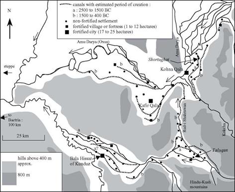
Figure 2.20 Irrigation canals in eastern Bactria on the eve of the arrival of Alexander the Great, near the confluence of the Oxus and the Kokcha (Gentelle, 1989; Gardiun, 1998). The irrigated fields are located between the canals and the rivers. The sites shown in italics (Shortughai and Taluqan) date from the IIIrd millennium BC.

habitation progressively migrates upstream as aggressive irrigation starves the down­stream extremities of the network.54 In Sogdiana to the north, one can also find rem­nants of early irrigation at Sarazm, on the Zeravchan River (the watercourse on which Samarcand is later founded). One also finds such traces on the lower course of the Oxus, to the southeast of the Aral sea, and at Dehistan, to the southeast of the Caspian (see Figures 1.3 and 7.1 for location maps).

Irrigated agriculture develops naturally in the valleys of the Oxus and its tributaries in western Bactria, at the foot of the great mountains of Hindu Kush and Pamir. French explorations conducted between 1971 and 1977 led to restitution of ancient canals, and helped establish a chronology of their evolution based on the dates of inhabited sites.[85] As agriculture spread to terraces situated higher and higher above the rivers, it was nec­essary to extend the canals so their intakes would be higher than the irrigated land, and to route the canals from one terrace to another. Often it was necessary to supply a canal from a tributary of the main river, sometimes far away, to bring water to the irrigated ter­races along the main river itself. For example, a plain that overlooks the Oxus at its con­fluence with the Kokcha was irrigated from the IIIrd millennium BC by a 25-km long canal fed by the Kokcha itself, and extending down to the Harappan settlement of Shortughai (Figures 2.20 and 7.2).

But even larger water resource developments appeared during the period from 1500 BC to the arrival of Alexander the Great – a period that also saw the development of major water supply in Assyria and Urartu. An artificial branch of the Taluqan River was excavated to develop the left-bank region of the Oxus, proceeding to the north against the natural drainage (Figure 2.20). This 50-km branch is today called the Rud I Sharawan. That the canal is artificial can be seen from its often perpendicular orienta­tion compared to the natural drainage. To the south, it follows the paths of old river arms or canals in the Taluqan plain; and to the north, it follows the valley of a small tributary to the Kokcha. The canal is deeply entrenched into unstable loess in its central portion that separates the drainage basins of the two rivers, attaining a depth of as much as 20 meters along one kilometer.

This is a significant operation of inter-basin water transfer, comparable to that implemented by Sennacherib to bring water to Khosr and Nineveh (Figure 2.15). Although it is impossible to say which of these developments came first, the necessary know-how clearly existed in both of these widely separated regions. What could have been the driving force for this project in Bactria: the decision of Persian leaders or the earlier work of a local Bactrian authority? Bactria had a strong cultural unity even before the arrival of the Persians. It may also have had strong political unity, but its his­tory is unknown.

The qanats: a new technique for obtaining water

When surface water cannot meet the needs of irrigation, one must tap groundwater. It was probably at the beginning of the Ist millennium BC, in Persia or in neighbouring lands, that a remarkable device for obtaining high quality water was invented: the qanat.[80]

This word means “reed” in Akkadian. The device comprises a gallery, or shaft, dug nearly horizontally from the flank of a natural slope back into the aquifer, but with a small slope (of the order of one or two per thousand) so that the water can flow out by gravity (Figure 2.19). In general, the construction of a qanat begins with the drilling of what will become its terminal well, called the “mother well”, through which the nature and level of the water table can be determined. Then the excavation of the gallery begins from the downstream end, making it possible to work in the dry until the aquifer is reached; this excavation thus proceeds all the way to the mother well. Intermediate wells, normally spaced at from 50 to 100 meters, provide for removal of the spoil from

The qanats: a new technique for obtaining water

Figure 2.19 Principles of the qanat: a technique for mining groundwater, apparently first appeared in Urartu (Armenia) in the 8th century BC, and then spread throughout the Persian Empire (Goblot, 1979).

the gallery, and provide for ventilation. The gallery can be several kilometers long, even reaching ten or more; the mother well can be the order of twenty to a hundred meters deep. The flow delivered by the qanat is generally from several, to several hundred, liters per second.

In 714 BC, Sargon II, king of Assyria (and the father of Sennacherib), is at war with king Rusa I of Urartu. He destroys the outposts of Urartu in the region of the lake of

Urmiah, as well as the qanats supplying water to the city of Ulhu, located to the east of this lake (60 km to the north of present-day Tabriz). The Assyrians, in a written account of this campaign, leave us an admirable description of the devices called “water outlets” that could comprise the first written evidence of the qanats:

“Ursa (i. e. Rusa) the king and lord of this land, pushed by his intelligence, showed his peo­ple how one manages the water outlets and creates a flow of water as copious as that of the Euphrates”.[81] [82] [83]

What is the genesis of this innovation? The Zagros mountains are a region of mines, especially in the area around the lake of Van. According to Henri Goblot, it was neces­sary to provide gravity drainage – to the surface – of certain mine shafts that were flood­ed after having pierced aquifers. In a country faced with the need to augment its water resources, the idea of making use of this drained water, and then to dig galleries express­ly for this purpose, surely picked up speed rapidly. The idea had a grand future: the Persians adopted it to develop the Iranian plateau, and in particular to provide water for their capital, Ecbatane. This is reported by Ctesias of Cnidus, a doctor of Xenophon’s expedition who was long held captive by the Persians:

“Having arrived at Ecbatane, a city located in a plain, she (again the legendary Semiramis! Here, it can only be a Mede or Persian sovereign) built a luxurious palace and she watched over the entire region with great care. The city was without water and there were no springs

in the vicinity; but Semiramis brought water to all the city, abundant and very pure water

52

thanks to her heavy investments.”

Cyrus brought the technique of qanats to Oman, and Darius brought it to the oases of Egypt. As we will see in subsequent chapters, the Romans developed the technique in all of the Near East, and as far as Tunisia, and the Arabs took it to Spain and Morocco. Migrants coming from the East brought it to the benefit of Saharan oases.