Category Water Engineering in Ancient Civilizations. 5,000 Years of History

The plain of lower Mesopotamia: irrigation, navigation, and river engineering from the Sumerian city-states to the Persian Empire

Irrigation practice in lower Mesopotamia

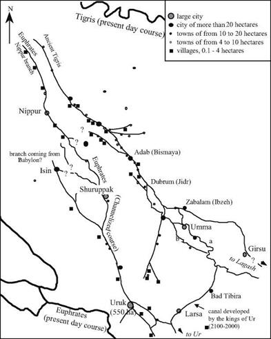
Field studies have shown that the urbanization of the Inrd millennium BC developed along watercourses, whether they were natural river branches or artificial canals. Notable among these studies are those of the American archaeologist Robert McAdams (Figure 2.3). However, it seems likely that at the time of the independent city-states, secondary irriga­tion canal systems remained essentially local, their layout dictated by the nature of the soil surrounding each city: a band of gardens here, a band of irrigated cereals there. Canals effectively define the boundaries between cities. And of course conflicts over the shared use of water arose along such boundaries. For example, around 2460-2400 BC there was a long dispute between the neighboring city-states of Lagash and Umma. Land conces­sions in the plain of Gu-edinna, at the boundary between the two cities, were taxed through payments in grain. When water users defaulted on their payments, the irrigation water was simply cut off. It was then necessary to resort to force, as occurred on several occasions

under Eannatum king of Lagash, then later during the reign of his nephew Entemena: “Eannatum, the ishakku (prinice) of Lagash, the uncle of Entemena, the ishakku of Lagash, marked off the boundary with Enakalli, the ishakku ofUmma; led out its (the boundary’s) ditch from the Idnun (canal) to the Guedinna; inscribed (several) steles along that ditch (….) He (Ennatum) levied a tax on them (in compensation for conceded lands) (….) Because this bar­ley remained unpaid – (besides) Ur-Lumma, the ishakku ofUmma deprived the boundary ditch of Ningirsu (and) the boundary ditch of Nanshe of water; ripped out its (the boundary ditch’s) steles (and) put them to fire (….) and (finally) crossed the boundary ditch of Ningirsu – Enannatum fought with him in the Gana-ugigga (where are) the fields and farms of Ningirsu, (and) Entemena, Enannatum’s beloved son, defeated him (….) At that time (however) Il, the temple-head of Zabalam, ravaged (?) (the land) from Girsu to Umma. Il took to himself the ishakku-ship ofUmma; deprived of water the boundary ditch of Ningirsu, the boundary ditch of Nanshe, the Imdubba of Ningirsu, that tract (or arable land) of the girsu tracts which lies toward

the Tigris (….) Entemena (…) made this (boundary) ditch from the Tigris to the Idnun in accor-

2

dance with the straightforward word of Nanshe.

Later on, development and use of the system of large canals saw coordination at a larg­er scale. Around 1800 BC, the great Babylonia king Hammurabi, who had just united the country, put forth a series of edicts, elements of a civil and penal code.

The prologue of this code notes that in the 33rd year of his reign the sovereign built a canal called “Hammurabi is the prosperity of the people”, designed to supply the Sumerian cities of Nippur, Eridu, Ur, Larsa, Uruk, and Isin. This suggests that the branch of the Euphrates flowing between Nippur and Uruk (see Figure 2.3) had been channelized.

This is also suggested by the proclamation of the 33rd year of the reign: “Hammurabi has dug the canal “Hammurabi is the prosperity of the people” – the canal that is taken care of by (the gods) An and Enlil – and thus provided the cities of Nippur, Eridu, Ur, Larsa, Uruk, and Isin with a steady supply of water for their prosperity and made it possible for the inhabitants of (the lands of) Sumer and Akkad, who had been scattered (by war), to return to their settlements”.

The code of Hammurabi includes edicts that regulate use of the irrigation system. It requires that riverside inhabitants maintain the dikes that protect the fertile lands near the rivercourses, and sets compensatory penalties for those who are remiss in this responsi­bility:

“If a man has been slack in maintaining [the bank of] his [field] and has not maintained [his] bank and when a breach has occurred in his [bank] and so he has let the waters carry away (the soil on) the water-land, the man in whose bank the breach has occurred shall replace the corn which he has (caused to be) lost.”

“If a man has released the waters and so has let the waters carry away the works on his neigh­bor’s field, he shall pay ten gur of corn for every bur of land.’0 [35] [36]

The plain of lower Mesopotamia: irrigation, navigation, and river engineering from the Sumerian city-states to the Persian Empire

Figure 2.3 Urbanization of the hydrographic network reconstituted between Nippur and Uruk, around 2500-2000 BC. This map is based on the work of the American archaeologist Robert McAdams. The hydrographic network is reconstructed from (undated!) artifacts of meander fossils and from the juxtaposition of the sites. It was not until the second half of the NIrd millennium BC (end of the ancient Sumerian dynasties and the empire of Akkad) that the rivercourses stabilized, undoubtedly under the influence of the artificial canals. The branch of the Euphrates between Shuruppak and Uruk, in particular, appears remarkably linear and regular from this period on. In the region of Umma, the principal course of the river shifts from (a) to (b) around 2400 BC. The large loop that flows toward the southwest and that supplies Bad Tibira and Larsa was most likely dug by the kings of Ur (2100-2000 BC).4 Uncertain branch locations are shown by “?”.

If gravity irrigation is to be used for large-scale cultivation of cereals, either the fields must be below grade compared to the river, whose bed is incised within the natu­ral levees caused by progressive alluvial deposits, or the canal must be constructed on raised fill to bring the water above the level of the fields.

Other texts contain evidence of a hierarchy in canal structure. The river branches or large navigable canals are called, without distinction, id in Sumerian, or naru in Akkadian. Along these narus, intake works supply secondary canals that in turn deliv­er water to basins called nag-kud in Sumerian or natbaktu in Akkadian. These basins are essentially rectangular reservoirs, varying in length from 12 to 72 m, and 1 to 12 m wide. These natbaktus are built on a plain by means of earthen dikes reinforced with grass or brush, from 1 to 5 m high. These reservoirs, apparently fitted with outlet gates, first pro­vided water storage, but also and importantly made it possible to redistribute water toward raised ditches along the top of small dirt ramparts that carried water into the fields.[37] The irrigation operations involved controlled flooding of fields to be cultivated. After sitting in the field for some time, the water is then drained, leaving the level and damp field ready to be plowed and planted. Once the new plants have germinated, the field is flooded once again, then twice more during the growth of the barley to improve the yield. This gravity irrigation was practiced from the very beginning, as shown in a collection of detailed advice from a Sumerian farmer to his son:

“When you are about to cultivate your field, take care to open the irrigation works (so that) their water does not rise too high in it (the field). When you have emptied it of water, watch the field’s wet ground that it stays even.. ,.”[38]

We also have direct external testimony, albeit delayed, of these irrigation works from Greek travelers. Perhaps in trying to understand the origin of war, Herodotus of Halicarnassae, a Greek citizen of the Persian Empire, traveled the known world follow­ing the Median wars during which the Persians burned Athens. Around 460 BC he vis­ited Egypt and Mesopotamia. Here is what he wrote about irrigation practices in the Babylonian region:

“Very little rain falls in the land of Assyria, and this little is what nourishes the root of the crop; but it is in its watering from the river that the corn crop wins to its ripeness and the bread grain comes into being. It is not as in Egypt, where the river itself rises over the fields; in Babylon the watering is done by hand-operated swing beams.”[39]

This text illustrates a second irrigation method – lifting of water to the crops to be irri­gated. The technique was probably used only for small-scale agriculture on the marshes. The “machine” most often used in this period was the shaduf a balance beam provided with counterweights (Figure 2.4). Its use appeared in Mesopotamia in the IVth millenni­um BC, and likely migrated into Egypt in the beginning of the IInd millennium BC.[40]
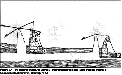
Подпись: Figure 2.4 The balance beam, or shaduf. - reproduction of a bas relief from the palace of Sennacherib at Ninveva, Moussly, 1951

The system relied on muscle power, but it was simple, efficient, and easy to main­tain. It became a permanent feature of traditional irrigation techniques of the Near East.
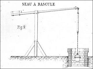
The plain of lower Mesopotamia: irrigation, navigation, and river engineering from the Sumerian city-states to the Persian Empireopposite, illustration from 1885 (Poillon, ancient archives of the Ecole Nationale des Ponts et Chaussees ENPC)

Another traveler, somewhat less of a passive observer than Herodotus, was Xenophon, a former student of Socrates. In about 400 BC, he joined in the adventure of an army of mercenary Greeks, the Ten Thousand, hired to support the revolt of a prince within the Achaemenids royal family. After the death of the prince and his generals, it was Xenophon who had to lead the difficult retreat. He crossed numerous canals between the Euphrates and the Tigris, a bit to the north of Babylon:

“…crossing on their way two canals, one by a stationary bridge, and the other by a bridge made of seven boats. These canals issued from the Tigris river, and from them, again, ditch­es had been cut that ran into the country, at first large, then smaller, and finally little chan­nels..”[41]

The irrigation principles of lower Mesopotamia were followed beyond the end of the Persian Empire of the Achaeminides. In the lowest areas of the plain, where the silts deposited by the two rivers caused the soil to be cohesive and sticky, constant work was necessary to keep the network in good operating condition. Later on, around the begin­ning of the modern (i. e. Christian) period, the Greco-Roman geographer Strabo writes: “Now this is the origin of the canals; but there is need of much labor to keep them up, for the soil is so deep and soft and yielding that it is easily swept out by the streams and the plains are laid bare, and the canals are easily filled, and their mouths choked by the silt; and thus it results again that the overflow of the waters, emptying into the plains near the sea, form lakes and marshes (….) And indeed there is also need of quick work in order to close the canals quick­ly and to prevent all the water from emptying out of them. For when they dry up in the sum­mer, they dry up the river too; and when the river is lowered it cannot supply the sluices with water at the time needed, since the water is needed most in summer, when the country is fiery hot and scorched; and it makes no difference whether the crops are submerged by the abun­dance of water, or are destroyed by thirst for water.”[42] [43]

We will see in Chapter 7 that this delicate equilibrium is not sustainable, though this does not become apparent for several centuries to come. Even so, a large canal will be built parallel to the Tigris and on its left bank (the nahr Awan), departing from the river at a point situated 24 km upstream of Samarra (about a hundred kilometers upstream of the present-day Baghdad), and terminating about a hundred kilometers southeast of Baghdad, collecting the waters of the Diyala along its way. It will be completed in the sixth century AD under the reign of the Sassanide sovereign Khusraw I.11

From Mesopotamia to the Syrian Shore: The land of the water pioneers

The triangle of land framed by the Tigris and Euphrates delta, Armenia, and the Syrian coast saw the development of the earliest large-scale techniques for water exploitation. From the IVth millennium BC through the conquest by Alexander the Great (in 331 AD), truly exceptional development occurred in this area.

The most important Sumerian city-states of lower Mesopotamia were Uruk and Larsa to the west; Umma, Lagash, and Girsu to the east; the large port of Ur to the south, and Nippur to the north. These cities imported wood and metals as raw material. The source was Bahrein (Dilmun) in the Persian Gulf, to which the following IIIrd millenni­um BC text attests :

”Ur Nanshe, the king of Lagash (…) dug a canal ( …) so that Nanshe could bring water into

the canal. Boats from Dilmun, that far-distant country, brought wood to him.”1

But these cities also traded with the upper valley of the Euphrates and Syria, and from this trade arose new cities on the Euphrates, like Habuba Kebira in the IVth mil­lennium BC, then Mari from the IIIrd millennium BC, as well as a veritable explosion of Syrian cities like Ebla, Aleppo, and Qatna.

The first political unification in this vast area from the Persian Gulf to the Syrian coast was achieved by Sargon of Akkad in the Kish region. But his successors (2340 to 2200 BC) found it difficult to maintain this union. The fall of this first Empire ushered in a new era of autonomy of the Sumerian principalities, including the grand kingdoms of Lagash, Ur, and then Larsa and Mari under Semitic dynasties. Later came the estab­lishment of the first empire of Babylon, which more or less included the domain of the conquests of Sargon of Akkad (1792 to 1594 BC).

A troubled period in the middle east began in the middle of the IInd millennium BC. This period saw competition among three great powers for Syria-Palestine: the Assyrian kingdom, the grand Hittite kingdom centered in Anatolia, and Egypt. At this time there was also rivalry for the plains of lower Mesoptotamia among the Assyrians, Babylonians, and Elamites.

Major migrations marked the transition from the Bronze to the Iron Age, around 1200 BC. In the near east, the Sea People (perhaps the Aegeans, themselves chased out by newcomers) left almost all the cities near the coast in ashes, and ended the Hittite Empire. Only Egypt, thanks to its power, successfully repulsed them. This troubled period does not end until the arrival of the Arameans from Arabia. They established a kingdom centered in Damascus about 1100 BC. Somewhat later, in about 1000 BC, David took Jerusalem from the Canaanites.

The great empires of Assyria, and then of Persia under the Achaemenids, were built on the ruins of this tumultuous period in the Ist millennium BC. The Assyrian Empire [34] reached its pinnacle between 890 and 606 BC, a period of delicate stability given the powerful rival Urartu to the north (Armenia), the revolts of Babylon, and the rise of the power of the Medes to the east. Assyria even extended its domination into Egypt, but only for a brief period. With the fall of the Assyrian Empire, Babylon again came to the forefront of the political scene in Mesopotamia, but not for long (604 to 539 BC). This period ends when the Persian, Cyrus the Great, and Cambyse, his successor, conquer the entire region, including Syria-Palestine, Anatolia, Egypt, and even Bactria.

From Mesopotamia to the Syrian Shore: The land of the water pioneers

Figure 2.1 Principal sites of ancient Mesopotamia; overview of the major hydraulic works.

This region is topographically unbounded, without natural limits or constraints. Civilizations came and went, but all of them depended on the efficacy of the irrigation systems inherited from their predecessors. Hydraulic technology, including the first great canals and dams, are passed from one civilization to another and spread outwards from the region. Let us first look at the great alluvial plain of lower Mesopotamia, the ancient land of Sumer and of Akkad.

From Mesopotamia to the Syrian Shore: The land of the water pioneers

Figure 2.2 The Euphrates valley and the irrigated plain upstream of Mari – looking downstream from the cliffs of Doura-Europos (photo by the author).

First of the maritime civilizations

We complete this overview of the very first hydraulic works with a brief look at early navigation, which has prehistorical origins. The migrations that accompanied the Neolithic spread toward the western Mediterranean are thought to have been by sea. The island of Cyprus, already populated in the IXth millennium BC from Palestine or from southeast Europe, experienced the neolithic migration about 7500 BC, including the arrival of cattle from the continent. Crete was populated about 6000 BC from Anatolia.

The Sicilian Neolithic was populated through seaborne migration from the Near East, thought to have passed through Greece on the way.[28]

A fundamental invention for the development of long-distance maritime commerce appeared in the IVth millennium BC: the sailboat. The oldest evidence is a boat model found in a tomb at Eridu, one of the oldest Sumerian cities, located to the south of Ur near the Persian Gulf (Figure 1.6). This model, dating from the first half of the IVth mil­lennium BC,[29] includes what is in effect a mast socket and attach holes for the stays. In addition, two other sailboat models that date from the IIIrd millennium and are similar to the one found at Eridu, have been recovered at the mouth of the Indus.

First of the maritime civilizations

Important maritime routes (Figure 1.3) provided very early links among the Euphrates, the region of Bahrain (Dilmun of the Sumerians), the Oman peninsula[30] [31] (Magan) and the Indus (likely the region called Meluhha). The Indus civilization found­ed a kind of trading base facing the Persian Gulf, at Suktagen Dor, as well as a port to the east, at Lothal. On this site there is a large rectangular basin made of clay bricks, and whose purpose is still subject to debate: freshwater reservoir, or basin of a port?

From the IIIrd millennium BC, Egypt also developed maritime routes, through the Red Sea to the legendary land of Punt (to the east of Sudan), and between the Nile and

the Phoenician ports of Byblos, and Sidon. The first evidence of a sailboat in Egypt, found on a vase (Figure 1.6), dates from about 3100 BC;[32] large seagoing sailing vessels appear in Egyptian engravings from 2400 BC.[33]

The first European civilization may be that of the Cyclades, in the Aegean Sea, in the Bronze Age during which commerce in metals plays an important economic role. Images of boats with tapered ends have been found on the island of Syros, engraved on objects of unknown usage, called “frying pans” by archaeologists, dating from about 2400 BC (Figure 1.8). These boats have many oars but appear to have neither mast nor sail; they are curiously similar to the boats with oars painted on Egyptian vases at the end of the IVth millennium BC. At the beginning of the IInd millennium BC, the Cretan navy operated shuttles connecting sites of the Aegean Sea, Syria (the port of Ugarit), Cyprus, Byblos, and Egypt. Cretan engravings and seals generally show boats with many oars, and a single mast carrying a sail. Starting in 1400 BC, the Greek navy, along with its Phoenician counterpart, protected and enabled long-distance commerce in the Mediterranean.

First of the maritime civilizations

Figure 1.8. Image of a tapered boat with numerous oars, after one of the objects called “frying pans” found at Syros, in the Cylades (about 2400 BC). Note the similarity with the boat of Figure 1.7, in particular the bow figurehead, here in the form of a fish (Sketch after Casson, 1971).

Construction of hydraulic works thus was clearly driven by the need for irrigation and flood protection. But it was also driven by the need to maintain fluvial communi­cation links, and to develop new maritime connections between the basins of the various major rivers. We will see several examples of this in later chapters, including on the Nile itself, between the Nile and the Red Sea, along the middle course of the Euphrates, between the Tigris and the Euphrates, and between the Yellow River and the Yangtze River – the famous Grand Canal.

Water in the early cities

Another dimension of hydraulics appears in the early cities: that of wastewater drainage. Many medieval and modern civilizations will come to treat this problem casually, and as a result endow their cities with an atmosphere of filth. Yet the early civilizations of the East were precocious in their concern for urban drainage. Evidence of the oldest known systems for draining water from houses can be found as early as the end of the Neolithic period, around 6500 BC, at El-Kowm.[24] These comprise plaster-lined gutters dug into the ground and crossing the doorsills, as well as holes pierced through walls, and even passages below the hard surface of the ground (Figure 1.4).

Mohenjo-Daro, in the Indus valley, gives us a particularly striking example of such hydraulic works at the scale of an entire city. Here there are about 700 cylindrical wells more than 15 m deep, often located within the houses themselves. Such houses are pro­vided with bathing rooms and often with latrines. The wastewater (including from the rooms above the ground floor) is drained through clay pipes which obliquely pass through the massive walls to connect to gutters covered with slabs, water being then con­veyed into brick-covered passages dug underneath the walks between houses, and final­ly into larger collectors. In these drainage systems, settling basins prevent blockage by debris. In alleys and passageways that are not on the drainage system, large bottomless urns serve as cesspools.[25]

A number of the early cities of Mesopotamia, at the end of the IVth or beginning of the IIIrd millennium BC, are similarly endowed with networks of wastewater and stormwater drainage.[26] These include Habuba Kebira, Mari, Eshnunna, then Ugarit in the IInd millennium BC (see the maps of Figures 2.1 and 4.1 for the geography of these cities). At Habuba Kebira, which is a Sumerian establishment of a thousand inhabitants founded about 3500 BC and occupied for only a century and a half, various systems are used to drain wastewater. The streets, well maintained and paved with an aggregate of gravel, are equipped with U-shaped gutters made from 64-cm long sections of clay, or sometimes from conduits covered with slabs of stone, draining wastewater and stormwa­ter outside the city walls. Even true conduits made from interlocking sections of clay pipe have been found.[27] At Mari, pipe networks whose total length can be greater than a hundred meters service multiple sanitary installations in the same house. But in Mesopotamia, this preoccupation with drainage seems to have faded away in time.

It is in Crete, in the IInd millennium BC, that we rediscover elaborate systems of water drainage – and for the first time also systems of water supply. We return to these in Chapter 4.

Water in the early cities

Figure 1.5 House with adjoining rooms at El-Kowm (about 6500 BC), with the remnants of drainage systems: the oldest known traces of water conveyance? (adapted from Stordeur, 1989).

Blessings and calamities

A flood in an alluvial valley is two-faced. It is always a threat when it is more severe than usual. But when well synchronized with the cycles of agriculture, the flood can be used to fertilize and water the soil before plowing and planting. This is the case with the

Figure 1.4 The deity “Nile” (Hapy), God of nourishment worshipped during the flood (note its full breasts), temple of Philae at Aswan (photo by the author).

Blessings and calamitiessummer flood of the Nile, which extends from June through August. The Tigris and Euphrates Rivers, on the other hand, flood in the spring (March through June), which coincides with the ripening of grains. Therefore in these regions, it is essential to com­plete the harvest before the flood – whose early arrival is always possible – can wash out the crops, especially from unprotected lands. In stark contrast to the hymns that laud the floods of the Nile, one can see a sense of urgency in a letter from a senior officer of the kingdom of Mari, located on the middle course of the Euphrates just downstream of the Neolithic site of Bouqras (see the map of Figure 2.1), written in about 1800 BC. The letter pleads to the king for help in completing the harvest before the early flood arrives: “My Lord: this is Kibri-Dagan, your servant. I realized that the river was in flood. It is wors­ening for three days I have undertaken to harvest the palace grain. But, the river is in flood. [….]. The remaining grain in my district exceeds my strength. If my Lord agrees, it is nec­essary to obtain help from Dumtan, Zurubban, and Hishamta (three villages in the region).

22

These workers must set out now for the water is already into the fields of Zurubban.”

The following letter from the same official shows the need to mobilize significant man­power to prevent flood damage:

“The Khabur (a tributary of the Euphrates) has flooded and Yaqqim-Addu sent me a message asking for help. I have called upon the people of Terqa (the city of which the author is the governor) and the people of my own district and I hastened to the aid of the flood gates

23

of Khabur. My Lord need not worry.” [22] [23]

In Egypt, the Nile flood is a blessing

Agriculture developed in Egypt about 5000 BC, perhaps under the influence of Mesopotamia and Syria. Subsequently, the need to take maximum advantage of the flood for land fertilization and irrigation led naturally to the organization of human resources for this purpose. Flood risk on the Nile is less than on the Euphrates and Yellow Rivers. The Nile has a relatively regular annual flood cycle, but still has suffi­cient variability, from one year to the next, to cause plenty or famine. The importance of the use of the flood in Egypt appears in numerous texts. In the Book of the Dead, in the heart of a long litany in which a person, embarking on a final voyage, proclaims his (or her) purity, are the following verses:

“I have not stopped water when it should flow. I have not made a cutting in a canal of run­ning water.”[19] [20] [21]

or again, from the Book of the Dead:

“O Osiris I am your son Horus and I come to work your fields for you.

“O Osiris I am your son Horus and I come to irrigate your land”

“O Osiris I am your son Horus and I come to work the land according to your intention”

20

“O Osiris I am your son Horus and I come to dig canals for you”

One can see in this hymn to the Nile, dating from about 1365 BC, a rather moving parallel between the blessings of the flood in Egypt and the benefits of the rain in other lands:

“Thou createst the Nile in the nether world below, and thou bringest it at thy will to provide life to the men of Egypt, the men thou created for thyself. […] Thou also giveth life to the most dis­tant foreign lands, for thou givest them the Nile descending from the heavens (i. e. rain). […] The Nile in the heavens is for the foreigners, and for all animals of foreign lands who walk on their feet. The Nile that comes from the world below belongs to the beloved Land.”^1

The Yellow River valley and its catastrophic floods

In China, agriculture first appears about 6000 BC along the Yellow River. Omnipresent in the beginnings of the Chinese civilization is the legend of its founding hero, Yu the Great. In about 2000 BC Yu was apparently “master of River Control.”

“In ancient times Emperor Уй deepened the rivers and saved the empire from flood, bringing relief and security to the nine provinces.”[17]

During this time, according to legend, “the flood waters rose as high as the sky”.[18]

Yu’s father, Kouen, had earlier been given the responsibility to curb the floodwaters, and constructed dikes over a nine-year period. But he failed in his assignment and thus was banished. Yu then decided to sacrifice himself to the river, taking the sins of all upon himself. The river, it was said, took half of Yu (tradition has it that half his face was shriveled and that he dragged one leg). He took a different approach from his dike­building father. During a period of 13 years, during which he never once returned to his home (according to legend), Yu dug canals and channels and dredged the rapids.

“He led the Rivers to the sea, as lords file to the court”.

Tradition credits Yu with a superhuman exploit: digging the channel of the Door of the Dragon (Longmen pass, see Figure 8.2) to provide an outlet for the waters of the Yellow River. Yu succeeded where Kouen had failed, and became the founder of the legendary first dynasty of Xia.

In ancient China, animals and even humans were sacrificed to the Yellow River before the followers of Confucius put an end to this practice. The battle to control the rivers, and to provide protection from their floods, is a constant theme in the hydraulic history of China. We return to this theme in Chapter 8.

The Indus and the Harappa civilization Bactria and the Margiana, on the banks of the Oxus

It is somewhat frustrating to write of the great civilization of the Indus Valley. Its ori­gins, near the beginning of the IIIrd millennium BC, are unknown; and the reasons for its demise, a thousand years later, hardly less so. What is known results from archaeo­logical digs at the two large sites of the twin cities Harappa and Mohenjo-Daro. The civ­ilization is thought to be the country called Meluha. The towns of the Indus civilization are built on terraces raised above the flood level, their perimeters protected from erosion by brick structures. One of the most notable aspects of these towns is, as we will see later, the large number of wells and the integrated water use in the housing, including wastewater drainage. The writing of the Indus civilization has not yet been deciphered. The civilization had maritime trade with Sumer, the two cultures having some elements in common.

It is known that there were also land links in this period between the Indus civiliza­tion and Mesopotamia, passing to the north by Bactria and the Caspian Sea, supporting the trade in lapis lazuli (a semi-precious stone).[15] Indeed, at Shortughai, in the eastern portions of the Oxus basin (present-day Amou Daria) the remains of a substantial estab­lishment of Harappean culture have been found. Here, in the middle of the IIIrd millen­nium BC, extensive irrigation was practiced, as evidenced by 25-km long canals (see

Figures 2.20 and 7.2). Moreover, Harappean relics have been found in towns that flour­ished to the west in the same period, such as Altyn, proof of long-distance commerce. Should one then consider the Indus as the origin of irrigated agriculture, key to the sub­sequent prosperity of central Asia, whereas conventional wisdom considers Mesopotamia to be the origin? The answer is not simple.

In the VIIth or VIth millennium BC the Neolithic revolution reached the regions to the southeast of the Caspian Sea, to the plains where the Gorgan and Atrek rivers flow, and to the foothills of the Kopet Dag mountains (Figure 1.3). The Jeitun culture that developed at the foot of these mountains had already likely developed modest irrigation, even if there is no formal proof of this. Somewhat later, population increase led to new

The Indus and the Harappa civilization Bactria and the Margiana, on the banks of the Oxus

Figure 1.3 From Sumer to the sites of the Indus Valley (Harappa civilization), and the Oxus Civilization, c. 2500 – 2200 BC. The oasis of Geoksiur is shown because of its importance to the history of irrigation, but its settlement dates from much earlier (5th and 4th millennia BC)

settlements to the east, first where the Tedzhen River forms a branched delta that van­ishes into the desert of Kara Kum, in the Geoksiur oasis. Artificial irrigation appears in this oasis during the IVth millennium BC. Russian archaeologists have studied deriva­tion canals extending perpendicular to the Tedzhen. These canals are 3 – 5 m wide, 0.8 – 1.2 m deep, and can be identified along a distance of 3 km. It is interesting to note, moreover, that the most active of this irrigation activity, supposedly the first to occur out­side of Mesopotamia, apparently coincides with the concentration of population into a single site of the oasis. The settlements had previously been dispersed around the oasis, suggesting that the irrigation efforts were a response to the gradual weakening of the water supply, a prelude to complete abandonment of the oasis. The neighboring cities of Namagza and Altyn, whose existence would be inconceivable without intensive irri­gation, surely were the destinations of the dislocated peoples. This culture and its tech­niques, conveniently called the Oxus civilization, come together later in the IIIrd and IInd millennia BC in all of the Bactria-Margiana region. Traces of this civilization have even been found to the north at Sarazm, on the Zeravchan River (later to become the sites of Boukhara and Samarcand).[16]

Despite the decline of urbanization in central Asia, including the disappearance of the cities of Altyn and Namagza in about 2200 BC, the destiny of Bactria and Margiana is to remain civilized, an obligatory passageway between Mesopotamia and the Far East. The destiny of the large cities of the Indus, on the other hand, is to vanish forever. After several centuries of existence, they become uninhabited, for reasons unknown. Around 1750 BC, Harappa is destroyed, and Mohenjo Daro is abandoned.

The myth of the Flood, a reflection of the ancestral threat of floods and inundations?

The Euphrates River, although less capricious than the great rivers of China, is subject to major floods and changes in course. The Flood is a common myth in all of Mesopotamia, existing in several versions. The oldest written version, written in Sumerian and discovered at Nippur, is unfortunately in very poor condition.[12] The most well-known version, the one that very likely inspired the biblical account in Genesis, is part of The Epic of Gilgamesh, a Babylonian account written in the first half of the IInd millennium BC in which the description of the event is situated in the Sumerian city of Shuruppak. Here is an extract:

“That stated time had arrived. In the morning he let loaves of bread shower down, and in the evening a rain of wheat. I watched the appearance of the weather—the weather was frightful to behold! I went into the boat and sealed the entry….

Just as dawn began to glow there arose from the horizon a black cloud. Adad rumbled inside of it, before him went Shullat and Hanish, heralds going over mountain and land. Erragal pulled out the mooring poles, forth went Ninurta and made the dikes overflow. The Anunnaki lifted up the torches, setting the land ablaze with their flare. Stunned shock over Adad’s deeds overtook the heavens, and turned to blackness all that had been light. The… land shattered like

a… pot. All day long the South Wind blew blowing fast, submerging the mountain in water,

overwhelming the people like an attack….

When the seventh day arrived, the storm was pounding, the flood was a war—struggling with itself like a woman writhing (in labor). The sea calmed, fell still, the whirlwind (and) flood stopped up.

I looked around all day long—quiet had set in and all the human beings had turned to clay! The terrain was as flat as a roof.”1J

Initially attracted by the desire to find traces of the great events of the Bible in the soil of Mesopotamia, archaeologists have searched for the ruins of the Sumerian villages in the signatures of the geological strata. Their studies have revealed significant and long-duration flood deposits, but only in some cities, and from different eras: At Ur from between 4500 and 4000 BC and then another episode dating from 2800 to 2600 BC; at Kish from three periods between 2800 and 2600 BC; and at Shuruppak, actually about 2900 BC.[13] [14] This city, which had been quite populous before, never again attained such status. No trace was found in the very ancient city of Eridu, despite its proximity to Ur (see Figure 1.3 or Figure 2.1 of Chapter 2 for the geography of these cities.)

The River: menace or blessing?

All of the great early civilizations were born in alluvial valleys – notably the Tigris – Euphrates delta, then the valleys of the Nile, the Indus, and the Yellow River (Figure 1.2). The soil in those valleys is fertile, but must be irrigated and drained, and this requires the establishment of coordinated water management. But there is another con­sideration: populations near the river are exposed to the deadly threat of flooding. Flood protection is therefore another fundamental need, demanding societal organization of significant manpower, and attracting population agglomeration to sites that can readily be protected. All of this implies a certain collective and hierarchical organization.

The River: menace or blessing?