Category Water Engineering in Ancient Civilizations. 5,000 Years of History

Hydraulics in the Mycenaean civilization in the second millennium BC

At the beginning of agriculture in Greece, Vth millennium BC, the abundant precipita­tion of spring and autumn obviated the need for irrigation. But irrigation eventually does develop in the Greek world. The earliest written reference to it comes from the Iliad:

“As one who would water his garden leads a stream from some fountain over his plants, and all his ground-spade in hand he clears away the dams (blockages) to free the channels, and the little stones run rolling round and round with the water as it goes merrily down the bank faster than the man can follow (.. .)”n

The Mycenaen civilization that develops especially from 1600 BC is the cultural heir of the Cretan civilization. The Acheans are the heroes of the principal Greek myths, myths that are surely the distant echo of a measure of historical reality. Jason and his quest for the golden fleece are the story of a commercial maritime voyage – or of plun­der. The adventures of Theseus and the Minotaur reflect the antagonism between the Acheans and the Minoans. The myth of Hercules, who changed the course of a river to clean the stables of Augias, surely echoes the mastery of river engineering that we illus­trate further on.

The Cretan cities and palaces: urban hydraulics brought to perfec­tion

Crete was inhabited by migration from Anatolia, probably at the end of the VIIth millen­nium BC. Its more highly developed civilization, the Minoan, dates from about 2100 BC. This maritime empire was apparently a peaceful one, since neither palaces nor cities were fortified – and this despite the threatening face of the monster that the legendary king Minos kept in his labyrinth according to the Greek legends of Theseus and Minotaur.[138] A creative and sophisticated urban and palatial architecture characterizes this civilization. The Egyptians know the Cretans as the Keftious, and Mesopotamians know them as the Kaptaras. The Cretans could not have been ignorant of the Eastern developments in urbanism and urban hydraulics, because at the same time northern Syria is experiencing the “belle epoch” of Mari (destroyed in 1761 BC), Elba (destroyed around 1600 BC, and Ugarit (destroyed about 1200 BC).

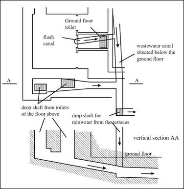
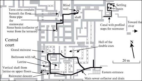
The remains of numerous cities have been found in Crete, as well as the remnants of four great “palaces” (or temples?): Knossos, Phaistos, Mallia, and Zakro. These cities and palaces have ample water supplies.[139] In the palace of Knossos, the largest in Crete, there are bathing rooms, latrines, and drains (Figure 4.4). These latrines have a “flush­ing” channel, dug into the floor, that is fed by an outside reservoir (Figure 4.3) and a sort of siphon, in an alcove of the back wall, connected to the drain. The bathing rooms have portable terra cotta bathtubs that can be arranged so that one can pour water over the bather from a separate room. Systems such as this, albeit of various degrees of sophist­ication, can be found in the other palaces on the island. For example, the guest quarters of Knossos include a room where voyagers can wash their feet in running water.

The Cretan cities and palaces: urban hydraulics brought to perfec­tion

Figure 4.2 Elements of a Minoan terra cotta pipeline (after Graham, 1987).

The Cretan cities and palaces: urban hydraulics brought to perfec­tion

Figure 4.3 Drainage of rainwater and wastewater, discovered in the east wing of the Knossos palace (Castleden, 1990). This area is at the lower left in Figure 4.4, which shows the overall layout of the eastern wing (see “latrine”).

But where does all this water come from? For Knossos, it is quite probably from a spring some 15 kilometers away. Terra cotta pipes following the natural slope of the land bring water first to the guest quarters, and then beyond to the palace. The pipeline cross­es a small river on a little bridge that provides access to the palace from the guest quar­ters.[140]

These Cretan aqueducts are, as far as we know, the first true water supply works. They were surely made of terra cotta conduits, and laid along the natural slope of the land, as were the later Greek aqueducts. And actual remains of terra cotta pipelines assembled from conical sections (Figure 4.2), that can fit into each other using flanged joints, have been found in Minoan palaces.[141]

Cretan urbanism is also remarkable for the way it uses rainfall runoff for sanitary purposes. In the palace of Knossos (Figure 4.4), Arthur Evans has identified laundries located at the eastern extremity of the palace. These laundries are apparently supplied by a pipe that descends along a stairway, bringing water from a basin where runoff from

The Cretan cities and palaces: urban hydraulics brought to perfec­tion

Figure 4.4 Hydraulic features identified in the eastern wing of the palace of Knossos. L = light well

the terraces is collected and stored.

In Knossos there are wastewater drainage systems, and the use of these same pipes for storm drainage further contributes to urban hygiene. Arthur Evans found two inde­pendent sewage networks in his excavations. One is made of terra cotta pipes, canals, and large collectors; the other uses smaller underground conduits. The system is serv­iced through manholes, and these manholes also capture rainfall runoff. Excavations directed by Nicolas Platon at Zakro have uncovered stone or terra cotta gutters under the floors, as well as masonry conduits covered with stone slabs. In the city of Palaikastro,[142] researchers have uncovered traces of stone gutters used to drain wastewater from hous­es, dumping the waste into the main sewer that flows under the central street. There is an analogous system of sewers in the Minoan city of Akrotiri on the island of Thera, buried around 1520 BC by the explosion of the volcano of Santorin.[143] Remnants of con­trol gates have been found at several of these sites.

The elaborate drainage systems of Crete mirror similar developments at other sites of the IVth and IIIrd millennia BC, such as Habuba Kebira and Mari on the Euphrates, Harapa and Mohenjo Daro on the Indus. It seems reasonable to suppose that the Minoan engineers were inspired by oriental concepts of drainage networks. It is, however, only in Crete that these networks are developed and generalized to the point that we have seen above. But as for the capturing and distribution of water for domestic supply, we are not aware of other examples in the orient prior to the Ist millennium BC. Therefore this was very likely a Cretan innovation.

Hydraulic works were also developed in support of agriculture. A canal network was constructed on the plateau of Lassithi, south of Mallia, for the drainage or irrigation of cultivated land. Recent detailed exploration of the region of Mallia, between 1989 and 1995, shows that the coastal plain was very actively cultivated in this period, in suf­ficient measure to feed the inhabitants of the 60 hectares of urbanized land around the palace. Gutters deliver water diverted from mountain streams to the fields through tem­porary storage in cisterns that are dug into the tops of hills.[144]

The Cretan cities and palaces: urban hydraulics brought to perfec­tion

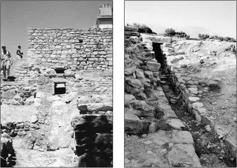
Figure 4.5. Outlets of the principal collectors of two Minoan palaces (photos by the author): – left, near the east entry of the Knossos palace; right, south of the Phaestos palace (under the large central court).

The Cretan palaces are destroyed several times by earthquakes, and then recon­structed. But the palaces, and the brilliant civilization of the island, come to an abrupt end about 1400 BC. The causes are not precisely known. It is possible that the explo­sion of the volcanic island of Thera (Santorin) caused an ecologic catastrophe when it covered part of the island with cinders, and that a tidal wave destroyed the island’s north­ern settlements. The bellicose Mycenaeans of continental Greece were also responsible for destruction of the palaces, symbols of the Minoan civilization. Only the Knossos palace survived for some time as the weakened seat of a power that seems now to have been Mycenaen.

These cataclysms, the explosion of Thera, the disappearance of Akrotiri, the abrupt end of Minoan commerce, are all probably the source of the legend of Atlantis, reported by Plato (427 – 347 BC) from Egyptian sources.[145] In any case, when he speaks of Atlantis, Plato gives tribute to the hydraulic developments of this legendary island, rec­ognizing both urban hydraulics and irrigation as shown in the following significant extract:

“I will now describe the plain, as it was fashioned by nature and by the labours of many gen­erations of kings through long ages. It was for the most part rectangular and oblong, and where falling out of the straight line followed the circular ditch. The depth, and width, and length of this ditch were incredible, and gave the impression that a work of such extent, in addition to so many others, could never have been artificial. Nevertheless I must say what I was told. It was excavated to the depth of a hundred, feet, and its breadth was a stadium every­where; it was carried round the whole of the plain, and was ten thousand stadia in length. It received the streams which came down from the mountains, and winding round the plain and meeting at the city, was there let off into the sea. Further inland, likewise, straight canals of a hundred feet in width were cut from it through the plain, and again let off into the ditch lead­ing to the sea: these canals were at intervals of a hundred stadia, and by them they brought down the wood from the mountains to the city, and conveyed the fruits of the earth in ships, cutting transverse passages from one canal into another, and to the city.”[146] [147]

Or again, this reference to the water supply:

“In the next place, they had fountains, one of cold and another of hot water, in gracious plen­ty flowing; and they were wonderfully adapted for use by reason of the pleasantness and excellence of their waters. Of the water which ran off they carried some to the grove of Poseidon (…) while the remainder was conveyed by aqueducts along the bridges to the outer circles (..)“

So here we may have direct tribute to the ancient know-how of the Minoans. But we must of course be careful to take these descriptions with a grain of salt, as they may just as easily reflect the ancient works of continental Greece.

The maritime civilizations of the Aegean Sea: urban and agricultural hydraulics

The first great European civilizations are found in and on the shores of the Aegean Sea – and thus in direct maritime contact with Egypt and Syrian ports. The earliest such civilizations are the Cyclades thalassocracy in the IIIrd millennium BC, the first mar­itime power of the Mediterranean; then Minoan Crete beginning at the end of the IIIrd millennium BC.[137] Civilization flourishes all around the Aegean Sea during the IInd millennium BC – especially in Crete, but also on the island of Cyprus, and in Asia Minor, with Troy to the north, and to the south Rhodes, Samos, and Kos. The first Hellenes came to continental Greece in several waves, and it is very likely around 1900 BC that Greek-speaking people appear – the Acheans. The warrior civilization that we call the Mycenaen developed from this time. Maritime trade is particularly active during this entire period – among all the European civilized lands, of course, but also with Syria, including the port of Ugarit to the north on the trade routes to Mari and to Hattusha, the capital of the Hittite Empire; and the port of Byblos to the south, threshold to Egypt.

The maritime civilizations of the Aegean Sea: urban and agricultural hydraulics

New arrivals from the north appear between 1200 and 1100 BC: the Dorians. This begins the disappearance of the Mycenaen civilization, whose survivors desert the cities.

Some flee to the islands and coast of Asia Minor (Ionia). This is possibly the origin of the “Sea People” that we met in Chapter 2, responsible for the burning and sometimes the disappearance of the main cites of Levant. The destruction of Troy is likely one of the episodes of this drama. In the Ionian islands, the memory of the bellicose Acheans is preserved in the Homeric poems the Iliad and the Odyssey.

The oasis of Maryab; the great dike on the wadi Dhana

Maryab is the largest city of the region during the period of the sudarabic kingdoms. It occupies some 90 hectares enclosed by a 4.5 km wall. The site, apparently dating from the IInd millennium BC, is located some ten kilometers downstream of a gorge through which the wadi Dhana leaves the mountains. This wadi, typical of others in the region, has only occasional but particularly violent floods (twice a year, in April and July – August). Its flood flow can be as high as 600 m3/sec.

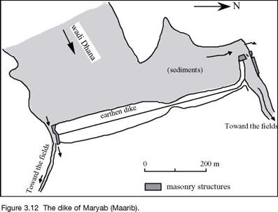
At first, partial diversions are employed to make use of water in the wadi, as is done throughout the region. Inscriptions from the 6th or 5th century BC mention the con­struction or rehabilitation of water intakes. As completed, these are massive installa­tions of cut stone, from which emanate two irrigation canals that branch out to deliver water to two vast irrigation zones on either side of the course of the wadi. At an unknown date (perhaps prior to, or perhaps after the 5th century BC), the bed of the wadi is blocked by a large earth dam, 15 m high and 650 m long, with rock protection on its upstream face. The reason for this dam, which is unique in the region, is proba­bly found in the continuously rising elevation of cultivated lands due to the deposition of sediments. The thickness of such deposits can reach 30 meters. One can imagine that the initial response to this increase in level is to move the intakes further upstream (there are remains of even older works downstream of the dam). But once the intakes had been moved all the way upstream to the narrow gorge from which the wadi Dhana emanates, the only solution became to raise the water level for the intakes by complete­ly blocking the gorge.

In its final form, the irrigation infrastructure of Maryab is truly impressive.[134] [135] It includes a vast reservoir that, during floods, extends 4 km upstream of the dam. The intake at the north edge of the dam includes two passages, 3 and 3.5 m wide and 9 m high, that can be blocked by sliding beams into grooves carved into the massive stone

blocks. These passages lead to a sort of stilling basin, whose outlet supplies a 14 m wide canal that is 1,100 m long. This principal canal ends at a stone distribution basin fitted with numerous channels leading toward secondary canals.

At the southern extremity of the dam, an 80-m long masonry revetment, 11m high, protects the flank of the dike and borders the intake channel, 4.5 m wide. Here again, grooves are provided for controlling the water flow. This intake structure provides access to another narrower canal, as on the north side, but it is only 4 m wide.

On each of the two banks of the wadi, there is a side weir that permits overflow of excess water back into the channel (Figure 3.12). The two irrigated zones, covering some 5,700 hectares to the north and 3,750 to the south, comprise the “two gardens of Sheba”, veritable oases that will later be celebrated by Arab writers.

The oasis of Maryab; the great dike on the wadi Dhana

It is quite likely that the capacity of the two outlets ends up being insufficient dur­ing large floods, given the continuous deposit of sediments in the reservoir. The dam is probably damaged, and perhaps fails, by overtopping on several occasions. According to inscriptions, there was a rupture that was repaired in the middle of the 4th century BC, and major reconstructions in 456, 462, 549, and 558 BC.52 The definitive failure of the dam, occurring in the 6th century BC soon after the last reconstruction, is mentioned in the Koran:

“There was surely a sign in their country, for the people of Sheba: two gardens, to the right and left (that is to say on each side of the wadi). (…).

But they sidestepped this. Therefore we send against them the flooding of the Dam, and we changed their two gardens into two gardens of bitter fruits, tamarix and jujube trees.”-”

The city of Maryab cannot survive this catastrophe, and is abandoned. [136]

The qanats in Egypt under the Achaemenid Empire

In Chapter 2 we described the invention of the qanat in Urartu and its development in Persia. After the conquest of Egypt by Cambyse, qanats are introduced in Egypt to irrigate the oases as well as the mountainous zones situated along communication routes (the wadi Hammamat, between Thebes and the ports of the Red Sea). Traces of three qanats constructed by order of Darius I (about 500 BC) have been found in the oasis of Kharga, some 300 km to the northwest of Asswan.[127] These qanats are as deep as 75 m, with a gallery several kilometers long and a rather flat slope compared to the usual prac­tice, only about 0.5 per thousand.

Irrigation in the land of the Queen of Sheba Irrigated oases at the threshold of the desert

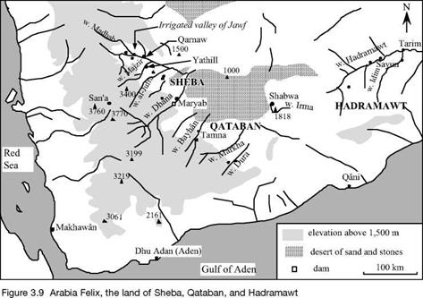
To the south of the Arabian peninsula, the mountains of Yemen rise to 3,000 m and capture the seasonal monsoon rains. The high valleys are therefore well watered – but the most prosperous regions are not found here. The shrubs from which incense and myrrh can be harvested are located, rather, on the edges of the arid interior desert, at about 1,200 m of altitude, in the lands of Qataban and Hadramawt. These aromatic resins become quite the fashion in all the countries of the East, in Greece, and eventual­ly in Rome, from the 8th century BC. The richness of this land, soon to be called Arabia Felix,[128] is built on incense and myrrh – their harvest, exchange, and associated control of the caravan routes that lead to the north of Arabia along the eastern edge of the great mountains.

However it is only through hard work that the kingdoms of Sheba, Qataban,

The qanats in Egypt under the Achaemenid Empire

Hadramawt, and Ma’in, whose capitals are Maryab (today Ma’arib), Tamna (Hajar Kulhan), Shabwa, Yathill (Baraqish), find prosperity. Nothing is possible without water, without crops. The land between the mountains and the desert is very arid; the only sources of water are the wadis. These are normally dry, but are subject to violent floods when heavy rains fall on the high mountains from which they issue, two or three times a year between March and August. People had learned how to make use of this water resource long before incense came into fashion – very likely from the IIIrd millennium BC along the wadis of Dura, Dhana and Markha; and from the IInd millennium BC in the basin of the wadi Hadramawt (along the wadi Irma upstream of Shabwa, in particular).[129]

The water engineering techniques remained about the same through the era of pros­perity of Arabia Felix. Deflector walls, weirs and small dikes, and occasionally true dams, constructed in the beds of the wadis, direct some of the silt-laden floodwaters toward a system of branching earthen canals. These canals are provided with outtakes – stones with grooves into which beams could be slid to control the water flow. Since the canals have a much gentler slope than the wadi, the currents are slower and therefore only the finest of the sediments are diverted to the crops with the water. The fields are quadrilateral in shape and surrounded by earthen levees, the whole comprising a vast irrigated zone. Gates permit controlled flooding of the fields to a depth of several tens of centimeters. Thus two resources are being used simultaneously: the water itself, making it possible to plant as soon as the field flooding is over; and the sediments, whose

The qanats in Egypt under the Achaemenid Empire

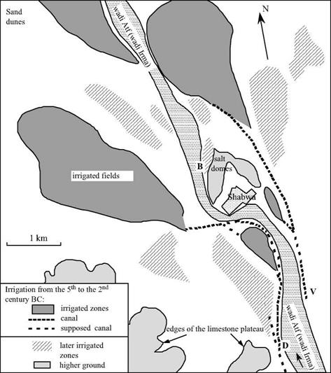
Figure 3.10. Reconstitution of the principal canals and irrigated zones around Shabwa, approximately between the 6th century (founding of the city) and the 2nd century BC – after Gentelle, 1992. The irrigated zones posterior to this period are also indicated. On the right bank, a large stone water gate (V) dates from the 2nd century BC; the deflector weirs (D and B) likely are from even later. On the two smallest ancient irrigated plots, just upstream of Shabwa, the thickness of the silt deposits reaches 15 m. The relatively steep slope of the wadi (5 m per km) makes it possible to cope with this downstream deposit, through modification of the locations of the intakes and canals. The desert is quite close, its first dunes appearing at the northwest extremity of this map.


deposition creates fertile layers of soil. Over the centuries, the thickness of topsoil increases, attaining some fifteen meters in certain locations (Figure 3.10), and even thir-


ty meters at Maryab. This accumulation of soil requires that the canal system be reworked periodically, the intakes being raised or moved further upstream so that the water can still reach the fields.

The qanats in Egypt under the Achaemenid Empire

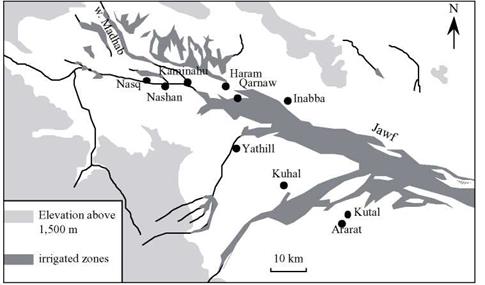
Figure 3.11. The irrigated valley of Jawf, and the city of the land of Sheba (Maryab is a little further to the south) – adapted from Robin (1991).

This mastery of complex hydraulic systems could not be achieved without a strong social organization. The kingdoms mentioned earlier are effectively organized and hier­archical. They are dominated by Sheba from the beginning of the 7th to the 1st century BC, under the hand of the great Sheban sovereign Karib’Il Watar, the “Karibilu king of Sheba” mentioned in texts of the Assyrian Sennacherib. The sudarabic writing is origi­nal, using an alphabet related to the Phoenician. Numerous inscriptions still exist, com­memorating for example the redistribution of irrigation water following the destruction by Karib’Il Watar of the city of Nashan, at the convergence of the wadis Madhab and Jawf (Figure 3.11):

“(Karib’Il Watar) took the rights of the king of Nashan and of Nashan to the waters of Madhab (…), took the water of dhu-Qafan at Sumhuyafa and at Nashan and grant­ed it to Yadhmurmalik, king of Haram, took from Sumhuyaga and at Nashan the canals dhat – Malikwaqih and granted them to Nabat’ali, king of Kaminahu, and at Kaminahu the waters of the canals dhat-Malikwaqih (that are) beyond the boundaries of Karib’Il, built the enclo­sure of Nasq and peopled it with Shebans.. ..”45

Another later text attests to the concession of irrigated land to a dignitary of the city of Haram (located several kilometers from Qarnaw):

“Wahab’il son of Ammidhara, of the clan of Thabaran (…), chief of the horse-mounted troops of Haram, honored Matabnatiyan, god of Thabaran, (…), when he dug, bore, and lined with stone his well, and that Yashhurmalik Nabat granted him a flooded public (?) land, of which he took possession, extending from the enclosure of Dhu-Arnab upstream to his property, and the concession that is upstream, between the canal of Dhat Batalan and the road of Ma’in, and he acquired and brought into cultivation a number of 300 (parcels).”[130]

Numerous texts also describe the construction of hydraulic works. The following extract, despite its gaps, describes the construction of a canal and dike, again in the region of Haram:

“(the person in question) bound and dug Yasim (?) with the upper canal of the plain of the city of Haram, next to (?) this canal and the tour, (…) and the land that is subject (?) to the king of Sheba (.) he granted his inscription and his dike.”[131] [132]

There are regulations to protect the waterways against thoughtless incursions. One of the earliest known is from the 5th century BC, after a certain Karib’Il Bayyin had built a runoff channel around the small city of Nasq (in Jawf, populated by Sheban colonists after the destruction of Nashan, as is referenced in one of the extracts cited above). His son is then led to issue a decree:

“Damar Alay Watar, son of Karib’Il, has decided and decreed, for Sheba and its colonists, the clearing of the water collector wall (deflector?) of the city of Nasq, that his father Karib’Il had opened according to the inscription of easement where his father delineated it in writing.

Neither watered nor arid land shall be developed therein, and no irrigated produce or crop

48

shall be harvested therefrom.”

Neither the regularity nor the amplitude of the beneficial floods is guaranteed, as is clear from the following text. Thus, if two clans have neglected the practice of a ritual hunt dedicated to the god Halfan, and there is a water shortage two times in a row, the clans must carve an inscription to do penance for their sin in the hopes that Halfan will again irrigate their lands:

“The clan Anir and the clan Athar have confessed and done penance to Halfan (the principal god of Haram after the 2nd century BC) because they did not render unto him the ceremoni­al (?) hunt in the month of dhu-Mawsab when they took refuge at Yathill during the war of Hadramawt, whereas they made the pilgrimage of dhu-Samawi at Yathill and put off the cer­emonial hunt until the month of dhu-Anthar. Therefore he (the god Halfan) did not grant them water for their irrigation network from the spring to autumn, because of an extremely low quantity of water, and they will be careful not to do the same thing again.”[133]

Thanks to these irrigation systems, artificial oases flourish along the wadis Dhana (we will come back to it later) and Markha, in Hadramawt (see also Shabwa on Figure 3.10). Although these regions have the oldest irrigation infrastructure, other systems are found on the wadi Bayhan in Qataban, where a 45-km continuous ribbon of land is irri­gated and cultivated. Arabia Felix has some thirty cities between the 7th and 1st cen­turies BC, in the grand valley of Jawf and near the wadis Dhana, Ragwan, Juba, Harib, Markha, and Hadramawt. Most of these fortified cities have surface areas of from six to ten hectares; but they have neither sewers nor water supply infrastructure.

In the 1st century BC, merchants of Alexandria discover how to make an annual maritime voyage toward India, using the monsoon. This is a negative development for the economy of Arabia Felix, which thus loses its monopoly on the supply of spices. This century thus marks the beginning of a slow economic recession. Upland tribes (the Himyarites) begin their progressive domination beginning in the 1st century AD.

A thousand years of traffic on the Necho canal

So what is the actual path of this ancient canal? We know it fairly well, since the remains observed in the twentieth century substantially agree with the descriptions of Greek and Roman travelers. The canal issues from the eastern branch of the Nile, follows the southern edges of the wadi Tumilat valley, passes by Tell er-Retaba and Tell el – Maskhouta (Tjekou), rejoins lake Timsah, then flows directly south toward the bitter lakes and the Gulf of Suez. Let us listen to a continuation of the account of Herodotus: “It takes four days to travel along it, and its width is such that two triremes could be rowed in it side by side. It is fed by the waters of the Nile, and begins a little above Bubastis (Tell Basta) by Pithon (Tell el-Maskhouta), an Arabian town. It ends in the Red Sea. The excava­tion was begun in the part of the Egyptian plain which is nearest to Arabia. The mountains where the stone quarries are and which are close to Memphis, are near this plain. The canal was dug along the foot of these mountains from west to east, passing through a gorge (the wadi Tumilat valley?). It turns to the south out of the hill country toward the Arabian Gulf.”

The outlet of the canal into the sea, at the end of the Gulf of Suez, is obviously an important and critical site. Apparently land transfer of goods, or boat portage (a com­mon practice in Antiquity), is necessary up until the era of Ptolemy II. In 280 BC he built the terminal facilities. Diodore of Sicily describes them thus:

“(Ptolemy II) conceived a barrier adroitly placed at the most favorable location. One opened

it when one wanted to pass and immediately closed it, for it was well 38

designed for this purpose.”

When Strabo visited the delta region, this installation was clearly in use. He certain­ly did not travel as far as the Red Sea, but his account confirms that the flow in the canal is from the Nile toward the lakes:

“There is another canal that flows in to the Red Sea and the Arabian Gulf near the city of Arsinoe (…). It flows through the lakes that are called bitter. Originally, these lakes were, without doubt, bitter, but when the aforementioned canal entered them, their waters, mixed with those of the river, changed nature and are today full of fish and inhabited by aquatic birds.”

Regarding the terminal facility of Ptolemy, Strabo’s account is somewhat vague: “the Ptolemite kings finished the excavation and closed the passage, in such a way that they could, at will, freely exit the canal into the sea outside and reenter into the canal.”[123] [124]

One can get lost among all the conjectures regarding this “barrier”. It was probably a single gate that could be opened when the tide equalized the water levels in the two water bodies, but surely was not a true lock[125]. One can only regret that Diodore and

Strabo did not leave us a more precise description of this “barrier”.

The canal will later be maintained and kept in operation by the Romans, who val­ued a direct pathway to the incense and myrrh of Arabia Felix. They named it Trajan s Canal after the work of this emperor, (who moved the point of entry toward Heliopolis, probably to improve the flow). The canal is also renovated and used by the Arabs, start­ing in 641 AD and up until its closure in 767 or 775 AD, to ship Egyptian wheat to Mecca and Medina. This closure was ordered by the Caliph Abu Jafr al-Mansur.[126] For twelve centuries, Necho’s project assures communication between the Red Sea and Indian Ocean with the Mediterranean Sea.

Few technological achievements can lay claim to such long success.

The great accomplishments of Egypt in the first millennium BC: from the last pharaohs to the Persians

Who dug the first “Suez Canal”?

Egypt had a long tradition of maritime commerce with countries on the shores of the Red Sea (in particular with the country of Punt, situated approximately east of Sudan and north of Eritrea). The port of Mersa Gawasis was founded in about 1900 BC under Amenemhat II (Middle Empire), somewhat below the 27th parallel (therefore a bit to the north of Thebes). Merchandise is carried by land to or from Thebes through arid val­leys, typified by the wadi Hammamat.

One can therefore readily appreciate the interest in a direct maritime link between the Nile and the Red Sea. Such a link was in fact realized though the valley of the wadi Tumilat with an east-west orientation. The remains of the canal were still visible in the 19th century, as described by Marice Linant de Bellefonds (1799-1883):

“More than forty years ago one could see, in the northern portions of today’s wadi Toumilat, the remains of an ancient canal that had rather small dimensions; it came from the west and flowed to the east along the desert and cultivated lands…. Near Tel-Retabee, this canal joined another much larger one, at a place called Ras el Wadi. this was the principal ancient canal..

It is there that the other canal from the northern portion joins the latter, which is much larger

30

and looks to be a very old and well built canal. u

All of the classic authors mention the existence of this very ancient and large-scale link. Certain of them (Aristotle, Strabo, Pliny) attribute the paternity of the canal to a pharaoh whom they call “Sesostris.”[115] [116] But archaeology clearly rules out the existence of such a communication link in the middle or new Empire. At best, one may consider the possibility that in the new Empire a small canal was constructed to transport stones from the Nile to the monuments constructed by Ramses II at the site known today as Tell

el Retaba. This is surely the small northern canal of the text cited.[117]

33

Modern studies[118] show that it is once again Herodotus who gives us the most pre­cise information. He situates the real beginning of the construction of the large canal during the reign of the Pharaoh Necho II, of the Saite Dynasty, who reigned in about 600 BC. This pharaoh, like most of his predecessors, pursued a policy of expansion toward the east, taking advantage of the fall of the Assyrian Empire. He builds a fleet of boats and embarks on an African expedition. Necho II founds the city of Tjekou, on the site of today’s Tell el Maskhouta, some fifteen kilometers to the west of the present Ismailia.[119] [120] Most of the canal was therefore built in that period (at least as far as Tjekou).

Two independent sources, that we will cite below, indicate the digging of the canal was not effectively ended until a century later, about 5009 BC, by order of the Persian sovereign Darius I.

Here is what Herodotus says:

“The son of Psammetichus was Necos, and he too became king of Egypt, and he was the first to attempt to dig a canal into the Red Sea; Darius the Persian was the second to dig it.”33

According to this author, some 120,000 workers were employed for the task by Necho. In 1866 Ferdinand de Lesseps, during his preliminary reconnaissance for con­struction of the Suez Canal, recognizes the traces of this ancient canal, well to the east of the vestiges found by Linant de Bellefonds.[121] At Kabret, 130 km from Suez on the isthmus of the same name, de Lesseps discovers a stela of pink granite engraved with the name of Darius, and with the following inscription in several languages:

“the king Darius declares: I am a Persian. From Persia, I took Egypt. I ordered this canal to be dug, from a river of the name of Nile, that flows in Egypt, to the sea that comes from Persia. Therefore, this canal was dug, as I had ordered, and boats go from Egypt, by this canal, toward Persia, as it pleases me.”[122]

The Persian’s strategic interest in this canal is obvious. But it is clear that Darius wrongly attributes the conquest of Egypt to himself, since this conquest was in fact accom­plished by his predecessor Cambyse. Therefore it is not surprising that he also exagger­ates his own role in the digging of the canal. Necho’s channel may have become clogged with silt or sand in the era of the sovereign Darius, who therefore would have re-excavat­ed it. It is also possible that the canal project undertaken by Necho was simply not com­pleted. In any case, three other stelas carrying the name of Darius will be discovered along the route of the canal, the most westerly being at Tell el-Mashkhuta (Figure 3.8).

The great accomplishments of Egypt in the first millennium BC: from the last pharaohs to the Persians

The search for Lake Moeris

Among all the Greek travelers, Herodotus is the only one to have visited this region (in 460 BC) prior to the new hydraulic works implemented by Ptolemy II in the 3rd centu­ry BC. Having admired the Labyrinth, the funeral monument of Amenemhat III, he then describes a lake of very large dimensions, oriented approximately north-south:

“Such was the labyrinth; but an even greater marvel is what is called the Lake of Moeris, beside which the labyrinth was built. The circuit of this lake is a distance of about four hun­dred and twenty miles (670 km!), which is equal to the whole seaboard of Egypt. The length of the lake is north and south, and its depth at its deepest is fifty fathoms (89 m). That it is handmade and dug, it itself is the best evidence. For in about the middle of the lake stand two pyramids that top the water (these are the colossi ofBiahmou), each one by fifty fathoms, and each is built as much again underwater; and on top of each there is a huge stone figure of a man sitting on a throne. The water that is in the lake is not fed with natural springs, for the country here is terribly waterless, but it enters the lake from the Nile by a channel; and for six months it flows into the lake, and then, another six, it flows again into the Nile.”[112]

One would hope that this account reflects the work of the pharaohs of the XIIth Dynasty, but Herodotus’ account is from more than a thousand years later. Herodotus is in fact describing the rather sad sight of the depression’s complete inundation, consistent with the geological descriptions cited earlier. The dimension that Herodotus indicates (a perimeter of 640 km), and the fact that the colossi of Biahmou are “in the middle of the lake” leave no doubt that this is the case.[113] The alternating current in the Joseph canal was probably, at this period, a simple natural phenomenon caused by season variations in the level of the Nile, unregulated by man.

And yet, as we have said, there logically must have been one or more temporary reservoirs to store and distribute the flood waters in the era of Amenemhat III, distinct from the Qaroun lake that occupied the lowest portion of the depression. These reser­voirs were situated above the irrigated lands, very likely near Shedet – Crocodilopolis and the mouth of the Joseph canal. Field studies conducted in 1988[114] made it possible to reconstitute the boundaries of a vast reservoir, located on the heights to the south of the depression as expected. The southern portion of the boundary approximately follows the contour +17 m, and to the north it is closed by a dam. This dam of Mala’a is 8,000 m long and four to five meters high. But the only remnants of its masonry construction that are visible today date from the Ptolemites (3rd century BC) – along with remnants of repairs from the Roman and Islamic eras. Older vestiges have not been found. The visible traces of the Illahoun dike (remains dating also from the 3rd century BC) suggest that it was 5 km long and four meters high. It is unlikely that we will ever know the details of engineering developments from the period of Amenemhat III with any certain­ty. Since the Ptolemite engineers gave the ancient name lake of Moeris to their reser­voir, it is possible that their work more or less replicated the preexisting system – but this is only speculation.

There remains another question: what has been the evolution of the “normal” level of lake Qaroun across the ages of its existence? As we have seen, the altitude of the monuments erected in the XIIth Dynasty argue for a lake whose surface is approximate­ly at elevation +10 m. It rises to +20 m when the Fayoun Depression is not isolated from the valley, and fluctuates with the floods. In the Ptolemite period, as we will see later on (Figure 5.8), the new developments will be around elevation 0 (even -10 m), an alti­tude that is surely suggestive of the lake level at that time. It is likely not until the time of the Romans that the lake level was lowered to its present level, 45 m below sea level, to increase the amount of tillable land.

Fayoun owes its history as one of the most productive regions of Egypt to the hydraulic works of the successors of Alexander the Great. Strabo visits the region in 25 BC (the labyrinth remains one of the most attractive curiosities to travelers), long after these new works have been implemented:

“It still remains that the lake of Moeris, by its dimensions and its depth, is capable of contain­ing, during the floods of the Nile, the excess water, without overflowing onto inhabited places and their crops; and at the moment when the river waters recede, it is capable of returning this excess water by the same canal, in each of its two outlets, while keeping within itself and the canal, a reserve of water to feed the irrigation canals. Whatever be the acts of nature, they have placed locks (ports or gates?) by means of which the engineers regulated the flow of water that enters and leaves.” (Strabo, Book XVII, 1-37)

Thus it is indeed the great reservoir of Mala’a that Strabo describes as the “lake of Moeris ”, rendering unwitting homage to the nearby remains of the old pharaoh.

The pharaoh and the lake: the great hydraulic works of the IInd millennium BC

In prehistory the Joseph canal, or Bahr Youssouf, supplied water to Fayoum through an ancient arm of the Nile. At that time Fayoum comprised an immense body of water and marshes, with a water surface elevation somewhat below that of the Nile. Little by lit­tle, sedimentation raises the elevation of the plain. In about 7500 BC, hydraulic con­

nection of the region to the Nile is not continuous but episodic, causing periods of rising and falling lake levels. Throughout the IIIrd millennium BC, the lake level appears to have remained low, at an elevation that is thought by some to be around -2 m,[106] the level of the Nile being around +20 m at this time. At this time the large lake was natu­ral, occupying roughly the area within the contour 0 on Figure 3.6. The lake supported fishing, and hunting along its shores.

About 2000 BC, possibly because of an exceptional flood, the water level in the Fayoun Depression abruptly rose to +22 m, and then fell again.[107] This surge of water inundated Kasr el Sagah (founded about 2400 – 2300 BC) where there was an embarka­tion embankment. After this episode, men started to have a hand in the evolution of the lake, at the height of the Middle Empire. About 1890 BC, Sesostris II begins the exten­sive work that is eventually finished 50 years later by his grandson Amenemhat III,[108] the sovereign whom the Greeks later called Moeris.

The pharaoh and the lake: the great hydraulic works of the IInd millennium BC

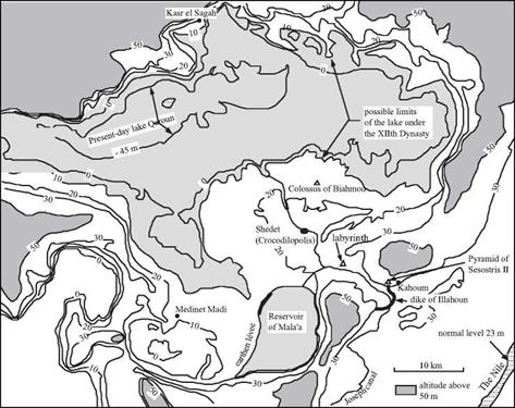
Figure 3.6 The Fayoum Depression and the “Moeris Lake”. We have shown on this map the 0,

10, 20, 30, and 50 m contours, from Ball (1939), as well as monuments and establishments of the XIIth Dynasty. Also shown are the hydraulic works (the Illahoun dike and the Mala’a reservoir) which have been dated in the 3rd century BC (Garbrecht and Jarritz, 1992). The normal level of the Nile is today at an elevation of 23 m; the flood level can attain 30 m.

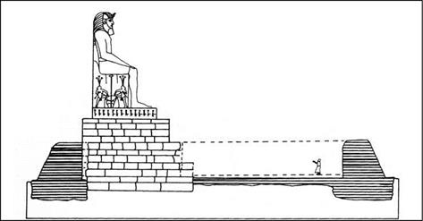
The work included widening the Joseph canal to 90 m, and building other irrigation and drainage canals. As a result, the now-cultivated region became an important eco­nomic center. The irrigation system undoubtedly used flood storage basins, as was the practice in Egypt. It is easy to suppose that the large artificial reservoir later recognized as Mala’a occupied the upper terraces to the south of the depression in one form or another, at an elevation sufficient to supply water to all of the region (there is no proof of this, however).[109] The capital of the Lake Province was then called Shedet (today Medinet el Fayoun), a city the Greeks will soon call Crocodilopolis since crocodiles are worshipped there. Amenemhat III had a tomb built so he could forever remain there, at Hawara. This is a pyramid associated with a vast temple called the labyrinthe, much admired by Greek and Roman tourists. This same king had a temple built near the pres­ent Medinet Madi, and another in the reconstructed colony of Kasr el Sagah. He also built two colossal statues at Biahmou, each twelve meters in height on a monumental pedestal, undoubtedly in his own image.

The pharaoh and the lake: the great hydraulic works of the IInd millennium BC

Figure 3.7 Amenemhat III looking over the Moeris lake – reconstitution of one of the colossi of Biahmou by the Egyptologist Sir Flanders Petrie (1899) (after Lane, 1985).

The Ptolemaic assertion that there were water control works at the entrance of Fayoun in this period (the Illahoun dike and its gates) has always been subject to some doubt. Yet one can see on Figure 3.6 that the monuments of the XIIth Dynasty are at an altitude of between +10 m and +20 m,[110] i. e. quite some distance below the flood level. Therefore it is easy to suppose that there must have been hydraulic works at Illahoun to isolate Fayoun from the rest of the valley and control the inflow of the Nile into the depression.

With the end of the XIIth Dynasty and of the middle Empire, in 1759 BC, came the troubles of the second intermediate period. During this period the maintenance of the Fayoun system was surely neglected. There is geological evidence of major inundations around 1700 BC, when the water level in the Fayoun Depression reached +22 m. Then again in 1500 BC it reached a record elevation of +24 m.[111] These floods were highly destructive, and the region never recovered its previous glory (at least not before the new developments of the 3rd century BC). Still, the region partially recovered in the period of the Ramses, when Fayoun hosted the great royal harem. A new series of troubles began in the 9th century BC, and with them surely came more uncontrolled incursions of the floods of the Nile into the Fayoun Depression. According to Butzer (1998), the water level in the Fayoun remains around +20 m from the 9th to the 5th century BC. It is easy to see from Figure 3.6 that the quasi-totality of the depression would be flooded at this level.

The “marvelous” lake of Moeris. Fifteen centuries of work to devel­op Fayoum

The Fayoum Depression, located 80 km southwest of Memphis (see Figure 3.1) in the “lake province” of the ancient Egyptians, was prized by the pharaohs and viewed as a marvel by Greco-Roman travelers. Strabo wrote:

“(This region) contains also this admirable lake that is called the Lake of Moeris and has the

dimensions and color of a sea.”[104] [105]

This region has a long history. It was first developed at the beginning of the IInd millennium BC by the pharaohs of the XIIth Dynasty. It was visited by Herodotus in 460 BC, and redeveloped by the Ptolemite successors of Alexander in the 3rd century BC. Strabo visits the region in 25 BC, at the dawn of the Roman domination during which Fayoum was one of the granaries. Today, the Qaroun lake sits in the depression, 70 m below the normal level of the Nile, with its rather barren shores. The observations of travelers, geologists, and archaeologists regarding the depression are often contradic­tory. This has lead to divergent interpretations of the developments in this region. But in forming such interpretations one must not forget that the history of the region spans more than fifteen centuries.