The great reservoirs of Ceylon
About 544 BC the island of Ceylon (Sri Lanka) falls under the domination of princely families of Indo-European origin, coming from Maghada. The Ceylonese civilization develops markedly after the conversion of the island to Buddhism. This conversion is attributed to a certain Mahendra who, according to tradition, is said to be the son or the brother of the great king Afoka. Irrigation is a significant factor in the island’s development. Rainfall is abundant, but concentrated during the monsoon period. Since the soil is relatively impervious, very little of the rain is stored as groundwater. The only solution is construction of dam-reservoirs.
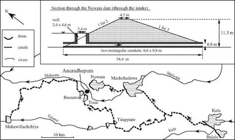
We can identify several reservoir-dam installations dating from 370 BC to 540 AD. They range in height from 5 to 20 m, and some are several kilometers long.[301] Eight of them are in the region of the capital Anuradhapura; three in the region of the great southern city, Magama, and four more near Polonnaruwa, which becomes the capital of the island after 781. All of these are earthen dams of trapezoidal section (Figure 7.3), fairly narrow at the top. The talus slope was rather steep for the first of these dams (370 BC), being 1:2.5 on both the upstream and downstream faces. Subsequent dams had somewhat flatter slopes, generally 1:3 on the downstream face (and in unusual cases, 1:5). These rather long dams are not rectilinear, but follow the terrain in such a way as to minimize their height and maximize the volume of stored water – which can be multiples of ten million cubic meters for the larger reservoirs. One dam near Polonnaruwa is an exception to this general configuration. It is relatively short, but is built to a height of 17 m at the time of its initial construction in around 300 BC, and then is raised to 34 m in 460 AD. Depending on the dam, floodwaters are spilled either over a natural rocky sill, or over a thick stone wall covered with a layer of large blocks. Often several dams are built on the same river, or on different tributaries of the same watershed. From the 5th century AD, canals that are 15 to 30 km long transfer water from one valley to another within the same overall watershed.
One of the reservoir-dam installations in the northwest portion of the island is gigantic, having an immense reservoir of 39 million cubic meters. The reservoir is contained by a semi-circular dike that is 9 km long. This project was first undertaken in the 12th century AD by the king Parakrama Bahu, but it remained unfinished, the necessary efforts exceeding the capacities of the population. Eventually Tamil invaders, coming from the south of the Indian subcontinent, replace the authoritarian dynasty that had developed such vast hydraulic resources for the island of Ceylon. The Tamils neither maintain nor further develop the hydraulic systems, which therefore progressively fall into decay and ruin.
|
Figure 7.3 Development of the basin of the river Malwatu near the ancient capital of Ceylon, Anuradhapura. The first man-made reservoirs are those of Bassawak and Tissa (about 300 BC), then Nuwara (80 BC), Balalu (40 BC), Mahawilachchiya (70 AD), then Kala and Tirappane (around 470 AD) and Machchaduwa (540 AD). The sketch shows the state of the development at the end of the 6th century AD, and the structural details of the Nuwara dam, 4.8 km long, creating a reservoir of 43 million cubic meters. After Schnitter (1994). |


Leave a reply